The Commercialization of Space Remote Sensing
Contents
The biggest advance in remote sensing from the 1990s into the next Millenium has been the significant privatization or commercialization of the field as it continues to grow through both aerial and space observing systems. The principal new feature of these systems is high spatial resolution - comparable to earlier “spy” satellites. The germane point: remote sensing has become a business, not just an endeavor by governments to demonstrate the value of going into space to learn about the Earth.
The Commercialization of Space Remote Sensing
Because of the great costs involved, most satellites that look at the Earth or make geophysical measurements have been conceived, designed, built, launched, and subsequently operated either by government agencies or have supported (underwritten) in part by government funds. Since the early 1960s, of the approximately 2400 satellites in orbit - with many active (now operating), most are/were either military in origin or flown as a general service by the U.S., France, Russia, India, Japan and other governments for scientific research and development or as monitoring systems that make environmental observations. Only about 100 of these satellites are/were developed by companies that have entered what can be called “Space business”. Most of those until recently have been Communications satellites. In that category are ComSat, IntelSat, PanAmSat, Inmarsat, and Eutelsat.
For much of this period, earth observations and resources satellites as well as most meteorological satellites - two groups relying on visual image gathering - have remained the province of governmental sponsorship and control. The shift from government programs for space platforms mounting remote sensors to programs devised and funded by private industry has been slow and only now, after 25 years since Landsat 1, has commercialization begun to take off. This contrasts with one of the first space programs developed by NASA aided by other federal agencies: namely, communications satellites, which with the incorporation of Comsat began in just a few years to assume a lead role in which development and funding from industry became the mainstay. Launch vehicles (i.e., rockets) also were built by commercial firms to put private satellites into space.
The success of the Landsats prompted other governments across the world to underwrite ventures into satellite remote sensing. Some of these branched into the private sector in time. The SPOT program developed by the French, with first launch in 1986, soon thereafter became the pervue of a commercial corporation. The Indian government began its IRS program in 1988. The European Space Agency (ESA) actuated its ERS-1 and -2 operational satellites beginning in 1990 as did the Japanese Space Agency (NASDA), with JERS-1 the same year. The Canadians entered the picture with their Radarsat in 1991. In all of these the governments developed and launched the satellites but either created or arranged with private corporations for the operation of the data gathering and distribution system. Perusal of some of the tables presented in this section indicates that governments are still key players in recent and impending launches of an ever-increasing variety of space platforms and sensor systems. But these tables also point to the expanding role of industry, as indicated by the planned launches of 4 or 5 privately funded satellites by the end of 1998. These satellites will provide for the first time the high resolution imagery which the industry believes is the key for economically successful earth sensing satellite ventures.
In the early days, the principal users of civilian remote sensing data (aside from the military who have always been involved in surveillance systems) in the U.S. were government agencies, state agencies, and academia. Gradually, industry came to recognize the basic value of the synoptic coverage afforded by space systems and started to purchase data in abundance.
To handle dissemination to all kinds of users, the Dept. of the Interior through its U.S. Geological Survey established the EROS Data Center in Sioux Falls, S.D. Its primary sales were a mix of Landsat data and aerial photography. NOAA continued to supply meteorological remote sensing output that rapidly began to effect forecasting and presentation of weather changes appearing in newspapers and on radio and TV.
A number of companies offering value-added services, mainly to industry, emerged starting in the 1970s. One familiar to this writer is the Earthsat Corporation in Rockville, MD, which could provide a wide range of capabilities including a full analysis of a given application problem. Others concentrated on providing software for image processing and analysis to be performed at the customer’s facility. ERDAS in Atlanta, GA. was one of the first in this field. Many other software programs have been developed since the 1970s, some by commercial firms and others by universities (e.g., IDRISI, used in this Tutorial; developed in the Geography Department at Clark University). As GIS grew into a major means of handling geospatial data and solving problems related to siting, land use, environmental monitoring, etc. a few companies, such as ESRI (Environmental Systems Research Institute) and Arc/Info sprang up to offer services and since then many more have joined in providing powerful programs that convolve GIS operations with image processing tools.
Some indication of the breadth of services now available from commercial organizations can be garnered from at the lists and ads in the Green Book: Who’s Who in the GeoTechnologies, published each year by EOM, Aurora, CO (http://www.eomonline.com).
The first push to privatize remote sensing is traceable to some key historical dates in the Landsat program. (This is treated in some detail in the Landsat Chronology put together by Ed Sheffner at the Ames Research Center [NASA], at: http://geo.arc..nasa.gov/sge/landsat/lpchron.html.) In 1979, NASA relinquished operation of its Landsats (Landsat-3 had been launched by then) to NOAA. At the start of the Reagan administration, the drive for commercialization was accelerated. During 1984, the Dept. of Commerce set into motion procedures for privatizing remote sensing in those areas under conditions that did not conflict with military interests. Out of this, an agreement was reached in 1985 for the newly incorporated Eosat in Landover, MD, formed by Hughes and RCA, to operate the Landsat program for 10 years while EROS continued in its role as the National Archive for all land images. However, in 1992 a government decision was made to return the development and launching of Landsat-7 to the Dept. of Defense in cooperation with NASA; DoD opted out of the program by 1996 and Landsat-7 was dovetailed into the EOS/MPTE program. By 1996, however, Landsat-7 had reverted to NASA to operate, with its data to be distributed by an EOSDIS facility built at the EROS Data Center to handle the distribution of the multi-terrabytes of data that will ensue from the MPTE program. It is noteworthy that Landsat-7 will be the first satellite ever to be programmed to gather and archive complete global land scene sets several times a year. The commercial entities’ policies are generally to acquire only scenes ordered by customers.
To assure that possibilities for commercialization of remote sensing satellites could prosper and continue on a parallel course with this and other government programs, an important workshop entitled The New Millenium Program was held at JPL in 1996 to foster coordination of government and private industry in those aspects of remote sensing that rely on expensive spacecraft to gather data.
The inception of commercial remote sensing probably began with the Eosat (now SpaceImaging) Corp.’s development in the 1980s as a business enterprise. Another early player in providing satellite remote sensing services was the Earthsat Corp., for years in Bethesda and now in Rockville, MD.
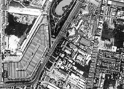
The big breakthrough in making remote sensing products both high desirable and readily available for general and commercial use was the result of the Russian program in the early 1990’s to sell high resolution data on the open market. Prior to that, military restrictions had placed a lower limit on allowable resolution so as to maintain the class of remote sensors that were known as “spy satellites”. The Russians, in need of foreign capital, released many of the photographs taken from space at resolutions of a few meters. In 1998, the Russian space program began to digitize their KR-1000 camera images, then placed these for sale to the entire world. This became known as the SPIN-2 program. Here is an example of a 2-meter image of central Bangkok, in Thailand:
(As a parenthetical aside, the writer [NMS] played a small but important role in this process by which the United States government decided to lift the ban on high resolution sensors that had been imposed because of militay considerations. Around 1987, the Soviet space program - strapped for hard cash - began selling in the open world market selected photos obtained by their cosmonauts and later by sensors on unmanned military satellites. A NASA official visiting Moscow was given one such product - a false color (but with no green band) photo that covered part of the Oregon northwest coast extending past Portland, OR. The Russians claimed at the time that this now-commercial product had better than 2 meter resolution. Concerned NASA Headquarter people wanted that claim to be tested/verified. I was given the photo and told to “solve the problem”. But no travel money to check the site itself. So I contacted a colleague at Oregon State University, Dr. Charles Rosenfeld pGeography Dept.] who taught a remote sensing course. He came up with a neat solution: he took his class to the airport outside Astoria, OR. On the blacktop runway, a series of white lines 6 feet apart had been painted perpendicular to the runway length as a marker guide for landing.. These were just visible with a magnifying glass on the Russian photo. This proved the veracity of their 2 meter claim.)
Soon after the Russian products appeared on the open market, encouraged by the anticipation that the United States would shortly waver its resolution restrictions various private corporations began to consider the possibilities in developing and operating high resolution satellites. These they would build but launch still required government-operated facilities - at first the U.S.(Vandenberg AFB in Calif.; Cape Canaveral in Florida), the French (in French Guiana along the northeast coast of S. America), and the Russians (in the northwestern Siberia and the southern steppes of central Asia). It was envisioned at this time that such satellites could compete with the aerial photography industry (although aerial photos can routinely provide pictures that were less than 0.3 meters in resolution). Thus, a combination of govenment-furnished space imagery and that supplied by private corporations - all with a range of resolutions and sensor systems - together moved earth observations into a new range of opportunities that have wide commercial implications.
Besides the U.S. Federal government, Canada, the Europeans, the Russians, the Indians, and the Japanese all have active remote sensing programs based on satellite observations; their products are available to anyone on a commercial basis. In the U.S., three companies are now launching their own satellites, lately on commercial rockets: Space Imaging, Inc, Digital Globe (formerly EarthWatch), Inc., and Orbital Imaging Corp.. All are supplying or will produce high resolution, multispectral products, as well as images taken with wide-angle viewing instruments that provide broad area coverage. We have seen several examples of these images in Sections of this Tutorial, including at the outset page 2 of the Overview. We now supplement these images with several examples that have been downloaded from the above Internet sites.
First, we feature SpaceImaging’s (headquartered in Thornton, Colorado) IKONOS-2; here is the satellite where it was built by Lockheed-Martin Missiles and Space Systems of Colorado:
This example shows a 1 meter image of Launch Pad 40, used mainly by the military at NASA’s Cape Canaveral:
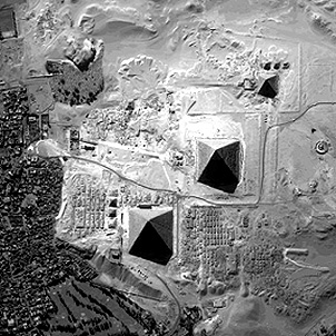
Here is a SpaceImaging high resolution panchromatic scene that shows the pyramids outside of Cairo, Egypt.
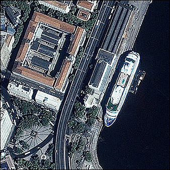
Two more, from this company. At the top is another 1 meter color image showing a cruise ship at berth in the harbor of Rio de Janeiro:
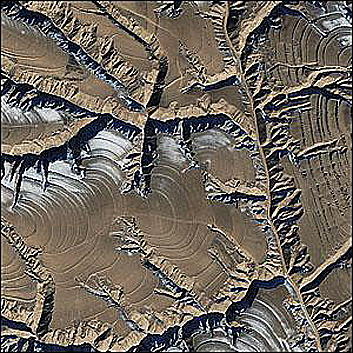
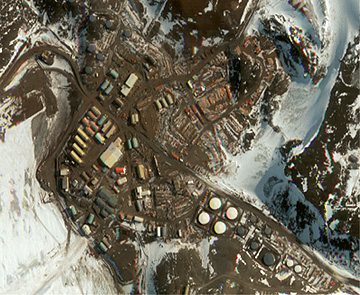
The other image, at 4 meters, shows a dissected plateau near Kelan in the Shanxi Province of China:
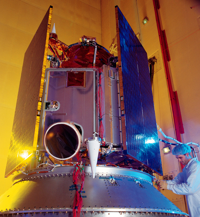
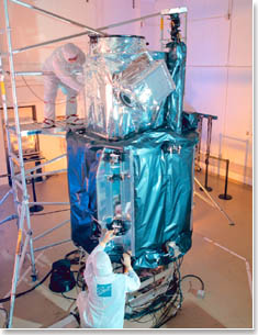
Quickbird-2 is the flagship of Digital Globe, a company located in Longmont, Colorado. Here is this spacecraft shown in its fabrications room at the builder, Ball Bros., also in Colorado:
The spacecraft orbits at 450 km. Its multiband sensors provide two levels of high resolution: 1) at 2.8 m, with red, green, blue and near IR; and 2) 0.7 m, with a panchromatic (wide wavelength) band and red and green bands. The next pair of images show part of Sunnyvale, California with the Moffett Field airbase next to which NASA’s Ames Research Center is located. The top image is at 2.8 m; the bottom a subset at 0.7 m.

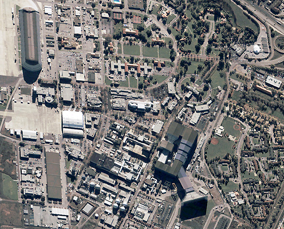
The lower image illustrates one problem that can distort and image. Note that some buildings appear to be non-rectangular and one tall building seems to be leaning. For low altitude aerial photography this occurs as described in Section 10 but in this case the spacecraft sensor telescope was not pointed vertically downward, so that all buildings tend to be misshapen.
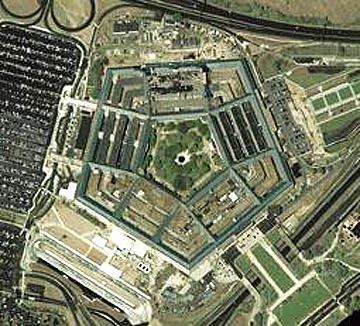
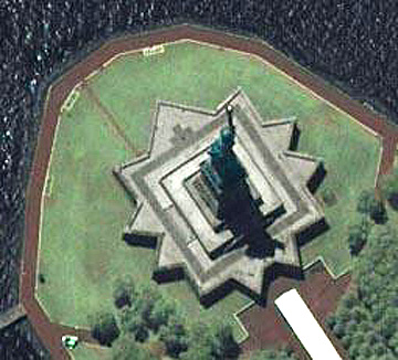
Here are three more Quickbird images, each looking at a noteworthy ground feature. The first pictures the largest community in the Antarctic, the McMurdo Sound Base managed by the United States. Below that is a view of the Pentagon (a year after it was damaged by a terrorist air assault) on the Virginia side of the Potomac River outside Washington, D.C. The bottom is a view of the Statue of Liberty in the New York Harbor at the mouth of the Hudson River, enlarged from the full Quickbird image.
Both SpaceImaging and DigitalGlobe really “came into their own” during the Iraqi war of 2003, since each provided exceptional images of all of Iraq both before and during the battles, as we have seen in the Overview. This provided exceptional publicity for the capabilities of their product. Another company, EarthViewer, Inc., which had previously sold maps and other information based on images from the two above companies, became a supplier to many of the TV networks covering the military campaigns in Iraq.
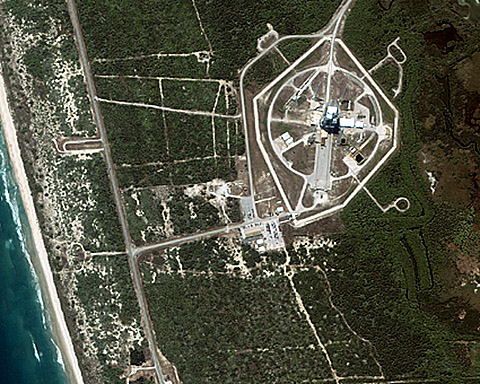
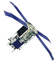
There is also a market for synoptic imagery, i.e, at the other extreme, in which large tracts of land or sea, at subcontinental scales, are depicted in color but at low resolutions. OrbImage (its full name is Orbital Imaging Corp.), headquartered in Dulles, VA, is presently filling this need. This company claims to have been the first to launch a purely commercially-developed remote sensing satellite in April of 1995. Its OrbView-1, shown below, was designed to monitor lightning worldwide, and needed only a panchromatic sensor at low resolution:
OrbView-2, launched in August, 1997, operates from an altitude of 765 km, and produces images with 1 km resolution that extend over a swath width of up to 2800 km; revisit time is 1 day. Its sensor has 8 channels ranging from 0.4 to 2.8 µm. Here is the “bird” before launch:
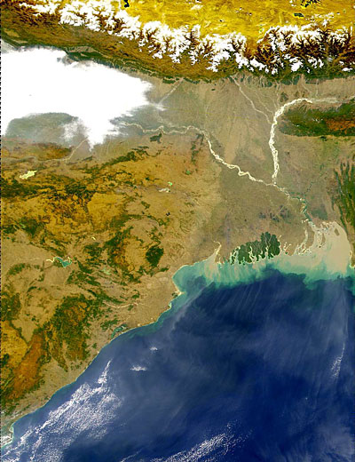
Two images exemplify the products currently being sold by OrbImage. The first shows Mexico; the second the Himalayas and northern India.

Reacting to the popularity of high resolution commercial imagery, OrbImage will launch OrbView-3 in the Spring of 2003 to a planned altitude of 470 km. Its 4-band (0.45 to 0.90 µm range) will provide images at 1 and 4 meter resolution, having dimensions of 8 km widths. OrbImage has also entered into partnership with MacDonald-Detwiler of Vancouver, BC to operate RadarSat-2 as a commercial venture providing radar imagery.
The future looks bright for commercial remote sensing (see Section 21 for additional information. As more users purchase these products, the prices of individual scenes have dropped to under $2000. The ability to get the data as individual bands, so as to allow some image processing like that described in Section 1 and Appendix B, makes these scenes ever more attractive compared to the more conventional aerial photography that met the needs of wide areas of coverage at high resolutions. In time, more companies, from different nations, will emerge on their own (without government subsidies). The sensor systems will tend towards wider spectral range coverage, including thermal. In the foreseeable future, hyperspectral remote sensing - the “creme de la creme” will become commonplace both from space and from aerial platforms.
One can argue that SPOT, RESURS, and ImageSat, International (Israel) are also viable private remote sensing corporations but these have had some assistance from their governments in the early stages. They thus aren’t quite as “pure” as the three American companies.
If you wish to learn more about the history and prospect for space commercialization of remote sensing, a tour of entries in your Search Engine will bring up 1000s of Web sites. Most are of limited value. Some tie commercialization with Space Law. The U.S. Congress has passed several enabling Acts. The Department of Commerce has part of the responsibility for satellite commercialization programs. Within NASA, the Stennis Space Center in Mississippi is managing many of the diverse space commercialization ventures. Some insight into how commercialization fits into satellite remote sensing can be gained from this Brief History of Operational Remote Sensing site. A review of difficulties as well as potentialities for commercial remote sensing is presented in this Rand Corp site (in .pdf format).