The Systems (Multisource) Approach to Remote Sensing
As may already be evident from earlier pages in this section, remote sensing data is of such nature and volume as to require it to be compatible with processing and outputing by computers. They are the easiest, fastest, and most efficient way to produce images, extract data sets, and assist in decision making. One special function is to assist in manipulating other kinds of data about the spatial or locational aspects of areas in the world that are the subjects of interpretation and decision making. Today, the approach to analyzing a problem or determining a plan dealing with some aspect(s) of monitoring or managing these areas for specific uses or development is embodied in the concept of a Geographic Information System (GIS). This page previews this tool but Section 15 will be devoted to understanding its capabilities and applications.
The Systems (Multisource) Approach to Remote Sensing
Since the early days of monitoring the Earth by orbiting spacecraft, the development of computer-aided techniques for reliably identifying many categories of surface features within a remotely sensed scene, either by photointerpretation of enhanced images or by classification ranks in itself as an outstanding achievement. Numerous practical uses of such self-contained information are being made without strong dependence on other sources of complementary or supporting data. Thus, automated data processing assists in recognizing and mapping, as an example, major crop types, estimating their yields, and spotting early warning indicators of potential disease or loss of vigor. However, many applications, particularly those involving control of dynamic growth or change systems, or decision making in management of natural resources, or exploration for nonrenewable energy or mineral deposits, require a wide variety of input data of various kinds (from multisources) not intrinsic to acquisition by spaceborne sensors such as those on Landsat, SPOT, and others of similar purpose.
Some data are essentially fixed or time-independent - slope aspect, rock types, drainage patterns, archaeological sites, etc. - in the normal span of human events. Other data come from measurements or inventories conducted by people on the ground or in the air - weather information, population censuses, traffic flow patterns, soil erodability, etc. However, many vital data are transient or ephemeral - crop growth, flood water extent, insect infestation, limits of snow cover, etc. - and must be collected in a timely sense. Pertinent remote sensing data play a key role in this last instance, and in fact satellite monitoring is often the only practical and cost-effective way to acquire data frequently over large regions.
A given scene imaged at different times of the year can show great variety. Changing Sun angles, atmospheric variations, seasonal differences in vegetation cover, presence of snow, and other variables will produce often pronounced contrasts in the spectral responses that determine “how an image looks”. This is evident in this montage of 6 Landsat MSS images of an area in the desert of Utah.

One should always keep in mind that remote sensing is an integral part of a larger Information Management System. In fact, in many applications, the user community employs remote sensing inputs as a key component of a continuing cycle of decision making. Consider this diagram:
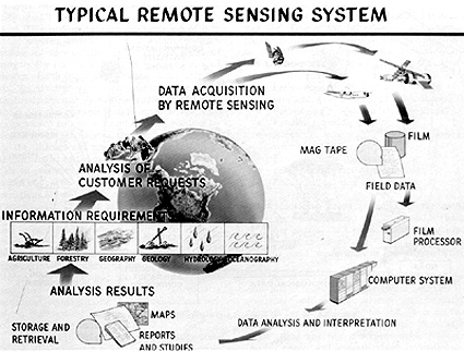
This chart shows a simple closed-loop cyclic process, unencumbered by the various feedback loops that no doubt exist. The starting point, and end point as well, is the set of panels labeled Information Requirements. This focuses on the ultimate driver of any information management system: the user and his/her recurring needs. Various disciplines concerned with Earth observations and resources are represented (one not shown is Meteorology). The terrestrial globe in the background reminds us that the system should be worldwide in scope. Information requirements logically lead to user/customer demands. The best remote sensing system approach is the one most responsive to these demands.
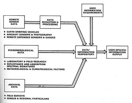
There has by now been full realization that the best current and future uses of most Earth-observing data from satellites (or astronauts) stem from correlating and interleaving this type of data with various other types that together are essential inputs to decision making and applications models. This is embodied in the “Multi” concept, described in Section 13 (page 13-4a ff), but summarized here by these terms: Multistage; Multilevel; Multisensor; Multispectral; Multitemporal; Multisource. Remote sensing data constitute an integral element of a more general Earth Survey Information System, as exemplified here:
The bulk of the data in such systems have in common a geographical significance, that is, they are tied to definite locations on the Earth. In this sense, they are similar to or actually make up what has become a powerful tool in decision making and management: the Geographic Information System (GIS; also known as geobased or geocoded systems). Because vast amounts of spatial or geographically referenced data must be gathered, stored, analyzed in terms of their interrelations, and rapidly retrieved when required for day to day decisions, a GIS that accepts these data must itself be automated (computerized) to be efficiently utilized.
The importance of GIS as a unifying means of handling geospatial data, including often mandatory inputs from remote sensing, warrants an extended explanation of how its works and what is does. This is the subject of Section 15. In Section 1 you will learn how computers with appropriate software are an essential part in processing, manipulating, and integrating data such as is the output of Landsat and other systems. It is safe to say that today, without computers, remote sensing from space would be next to impossible.