History of Remote Sensing: In the Beginning
The chronological development or history of the use of remote sensing from platforms that fly or orbit above the Earth�s surface is introduced on this page. Brief mention is given to the history of aerial photography. Examples of image products photographed from sounding rockets, from one of the first satellite-mounted remote sensors, and taken by astronauts are presented. Links are provided to three Tables, each outlining some aspect of the history of remote sensing.
History of Remote Sensing: In the Beginning
Remote sensing as a technology started with the first photographs in the early nineteenth century. Many significant events led to the launch of the Landsat satellites, which are the main focus of this tutorial. To learn about the milestones in remote sensing prior to the first Landsat, you can view a timeline of remote sensing in one of three areas - Photographic Methods, Non-Photographic Sensor Systems, Space Imaging Systems (taken from a table that appeared in the writer’s [NMS] NASA Reference Publication 1078 [now out of print] on The Landsat Tutorial Workbook). That review ends with events in 1979. You can also find more on the general history of U.S. and foreign space programs in Appendix A and at this online Web site: review-3.
We present major highlights subsequent to 1979 both within this Introduction and throughout the Tutorial. Some of these highlights include short summaries of major space-based programs such as launching several other satellite/sensor systems similar to Landsat; inserting radar systems into space; proliferating of weather satellites; launching a series of specialized satellites to monitor the environment using, among other, thermal and passive microwave sensors; developing sophisticated hyperspectral sensors; and deploying a variety of sensors to gather imagery and other data on the planets and astronomical bodies.
The photographic camera has served as a prime remote sensor for more than 150 years. It captures an image of targets exterior to it by concentrating electromagnetic (EM) radiation (normally, visible light) through a lens onto a recording medium. The Daguerrotype plate was the first of this kind. A key advance in photography occurred in 1871 when Dr. Henry Maddox, a Brit, announced development of a photographic negative made by enclosing silver halide suspended in an emulsion mounted on a glass plate (later supplanted by flexible film that is advanced to allow many exposures). Silver halide film remains the prime recording medium today. The film displays the target objects in their relative positions by variations in their brightness of gray levels (black and white) or color tones (using dyes, as discussed in Section 10).
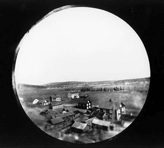
Although the first, rather primitive photographs were taken as “stills” on the ground, the idea photographing the Earth’s surface from above, yielding the so-called aerial photo, emerged in the 1860s with pictures from balloons. The first success - now lost - is a photo of a French Valley made by Felix Tournachon. One of the oldest such photos, of Boston, appears on the first page of the Overview. The first free flight photo mission was carried out by Monsieur Triboulet in 1879. Meanwhile, an alternate approach, mounting cameras on kites, became popular in the last two decades of the 19th Century. E. Archibald of England began this method in 1882. Here is a well-preserved photo (1889) from a kite, snapped by a remote mechanism operated by A Balut, covering Labrugauere, France:
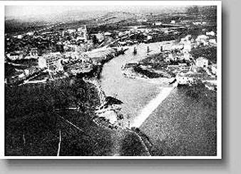
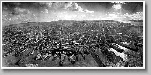
G.R. Lawrence took several famous kite photos of the devastation in San Francisco, California right after the infamous 1906 earthquake that, together with fire, destroyed most of the city. Here is the best example:
It appears that Wilbur Wright - the co-developer of the first aeroplane to leave the ground in free flight - himself was the first to take pictures from an airplane, in France (LeMans) in 1908 and Italy (Centocelli) in 1909.
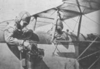
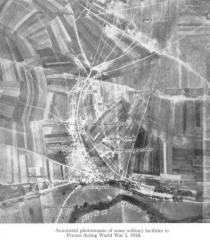
By the first World War, cameras mounted on airplanes, or more commonly held by aviators, provided aerial views of fairly large surface areas that were invaluable for military reconnaissance. This is docmented in these two photos:
From then until the early 1960s, the aerial photograph remained the single standard tool for depicting the surface from a vertical or oblique perspective. More on aerial photography is reviewed on page 10-1.
Historically, the first photos taken from a small rocket, from a height of about 100 meters, were imaged from a rocket designed by Alfred Nobel (of Prize fame) and launched in 1897 over a Swedish landscape:
A camera succeeded in photographing the landscape at a height of 600 meters (2000 ft) reached by Alfred Maul’s rocket during a 1904 launch:
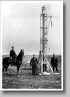
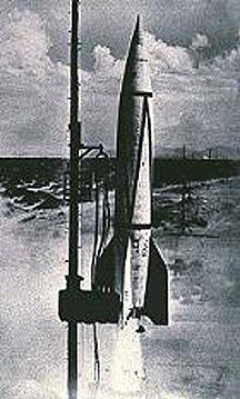
Remote sensing above the atmosphere originated at the dawn of the space age (both Russian and American programs). At first, by 1946, some V-2 rockets, acquired from Germany after World War II, were launched by the U.S. Army from White Sands Proving Grounds, New Mexico, to high altitudes (70 to 100 miles). The first V-2 launch in the U.S. took place in April 17 of 1946. Launch 13 in the V-2 series (which the writer witnessed from a distance while stationed at Fort Bliss, El Paso, TX to the south), on October 24, 1946, contained a motion picture camera in its nose cone, which acquired a series of views of the Earth’s surface as it proceeded to a 134 km (83 miles) altitude. The writer later was assigned as a Post newpaper reporter privileged in Spring 1947 to attend a V-2 launch at White Sands and to interview Werner von Braun, the father of the German V-2 program and a prime mover of the Apollo program; little did I know then that I would be heavily involved in America’s space program in my career years. V-2 pictures are included in an October 1950 article “Seeing the Earth from Space” in the National Geographic. We show here a photo of one of the White Sands launches of the V-2 - a precursor to the Saturn Rocket which propelled astronauts to the Moon.
Here is a picture from a later V-2 launch that shows the quality of detail in a scene in nearby New Mexico just north of the White Sands launching site:
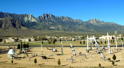
Smaller sounding rockets, such as the Wac Corporal, and the Viking and Aerobee series, were developed and launched by the military in the late ’40s and ’50s. These rockets, while not attaining orbit, contained automated still or movie cameras that took pictures as the vehicle ascended. In these early days there were many variants of sounding rockets, along with those being groomed for eventual insertion of objects into orbit. An outdoor display of these at the White Sands Museum is impressive:
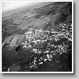
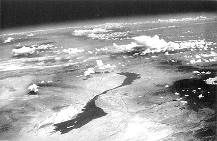
Here is an example of a typical oblique picture made during a Viking Flight in 1950, looking across Arizona and the Gulf of California to the curving Earth horizon (this photo is shown again in Section 12).

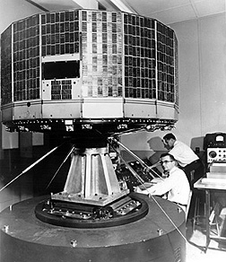
The first non-photo sensors were television cameras mounted on unmanned spacecraft and were devoted mainly to looking at clouds. The first U.S. meteorological satellite, TIROS-1, launched by an Atlas rocket into orbit on April 1, 1960, looked similar to this later TIROS vehicle.
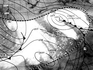
TIROS, for Television Infrared Observation Satellite, used vidicon cameras to scan wide areas at a time. The image below is one of the first (May 9, 1960) returned by TIROS-1 (10 satellites in this series were flown, followed by the TOS and ITOS spacecraft, along with Nimbus, NOAA, GOES and others [see Section 14]. Superimposed on the cloud patterns is a generalized weather map for the region.
Then, in the 1960s as man entered space, cosmonauts and astronauts in space capsules took photos out the window. In time, the space photographers had specific targets and a schedule, although they also have some freedom to snap pictures at targets of opportunity.
|
|


(Note: these images, and many others in the Tutorial, have a thin blue border; this means that you can click inside it and it will automatically enlarge to fill most of your screen. To close, try pressing escape, then close, using the X button in the upper right, or on some browsers, just try X first)
During the ’60s, the first sophisticated imaging sensors were incorporated in orbiting satellites. At first, these sensors were basic TV cameras that imaged crude, low resolution (little detail) black and white pictures of clouds and Earth’s surface, where clear. Resolution is the size of the smallest contrasting object pairs that can be sharply distinguished. Below, we show three examples from the Nimbus satellite’s sensors to give an idea of how good the early photos were.
**| Nimbus satellite image of parts of eastern India and Bangladesh, the main chain of the Himalayas, and the Tibetan Plateau to the north. |** Eastern India, Bangladesh, Himalayas |
|Nimbus satellite image of parts of eastern India and Bangladesh, the main chain of the Himalayas, and the Tibetan Plateau to the north. | Saudi Arabia |
 **
Eastern North America**
**
Eastern North America**
Early on, other types of sensors were developed that ” took images using the EM spectrum beyond the visible, into the near and thermal infrared regions . The field of view (FOV) was broad, usually 100s of kilometers on a side. Such synoptic areas of regional coverage were of great value to the meteorological community, so that many of these early satellites were metsats, dedicated to gathering information on clouds, air temperatures, wind patterns, etc.