The Middle East and Africa
Contents
Most of the northern third of Africa and the adjacent Middle East has landscapes that are the product of past and current arid to semi-arid conditions. The central third of Africa in many places is much more heavily vegetated, including tropical rainforests. The southern third of that continent again reverts to semi-arid conditions in which savannah vegetation is particularly common.
The Middle East and Africa
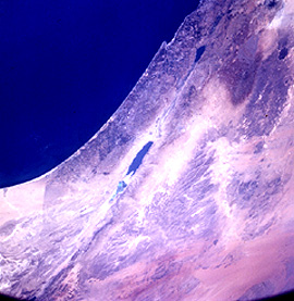
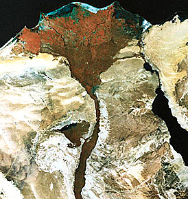
The first image is a mosaic showing the “hot spot” of the Middle East, Israel and neighboring countries, a land of seemingly never ending strife and hostility but also with Jerusalem as the site of ancient holy places associated with three great religions. The Sea of Galilee and the Dead Sea (south) both lie astride the great Dead Sea fault, a strike-slip fracture akin to the San Andreas fault; here too is the boundary of two tectonic plates. Lebanon (with Beirut), part of Syria (with Damascus and the Golan Heights), Jordan, and a sliver of the Sinai Peninsula all appear in this image.
and Jordan; the Dead Sea fault is conspicuous.|
It is informative to compare this mosaic with an oblique photo looking west as taken by astronaut Shannon Lucid from the space station MIR. While the latter presents a different perspective, it does not bring out the scene richness that the computer-processed Landsat mosaic offers. Note on the left the boundary between Israel and Egypt’s Sinai; land use practice through irrigated farming by the Israelis accounts for this. More on human photography from space in Section 12.
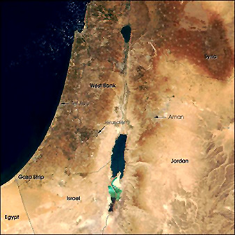
A closer look at this Mideast center of history and current trouble spot is offered in this Terra MODIS view (below), with some of the geographic features in Israel, the West Bank (Palestine) and neighboring countries identified by annotation. The green area at the bottom of the Dead Sea is a manmade evaporation basin in which salt is extracted from the saline waters piped in from this body of water which is largely below sea level.
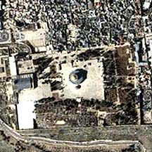
The Holy City of Jerusalem appears as a darker “blotch” in the Terra image. An ASTER image shows a close-up of Jerusalem (this image indicates the the areal extent of Jerusalem is not that large):

This is an aerial oblique view of the inner part of greater Jerusalem:
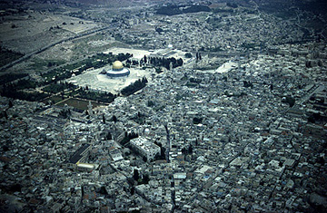
The golden domed building is the Dome of the Rock, a holy Moslem shrine that lies within the Old City (walled). It is visible as a yellow dot just left of center in the ASTER image.The sacred ground of the Old City has been subdivided into four sectors: Armenian; Christian; Jewish; Moslem. Some of East (Moslem) and West (mainly Jewish) Jerusalem is in this scene but modern Jerusalem extends well beyond.
The Dome of the Rock dominates this high resolution IKONOS image of the Old City:
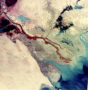
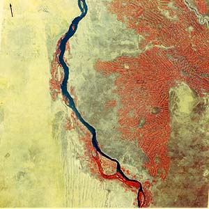
The next image is another Landsat scene of an area to the east of Israel. The mouth of the fabled Tigris and Euphrates Rivers empties through a delta into the Persian Gulf in southeastern Iraq. Those rivers meet into a single channel, the al Arab, in the swamplands in the upper left of the image. Crops along the river include wheat, millet, sorghum, cotton, rice, and dates. The Rivers Karun (top center) and Jarrahi (right center) are both in western Iran. The lower left corner is a barren desert, with sand dunes, which includes part of Kuwait, over which the Gulf War in 1991 was fought between a coalition of nations and the Iraqui invaders (see page 13-4c). Several black plumes of smoke emanate from the burning of gases released from oil fields. Kuwait lies atop one of the richest concentrations of oil and gas in the world.
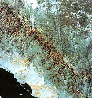
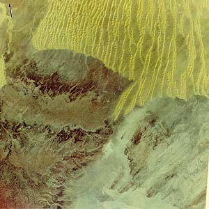
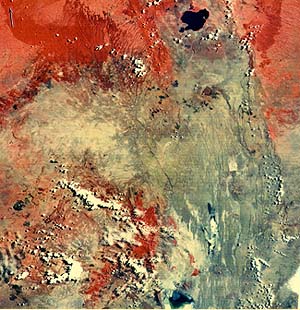
Much of the Arabian Peninsula - actually a huge, wide land mass bounded by the Red Sea and Persian Gulf and thus not strictly a peninsula in geographic terms - is covered by barren desert and vast sand seas. But, as seen in this mosiac its western side is composed of the Arabian Shield, a great mass of crystalline rocks (mostly metamorphic) that were once part of eastern Africa until separated by plate tectonic rifting in the Tertiary Period. The highest part in this scene is a dissected scarp that runs from along the west edge. The scarp in places is almost 1.6 km (1 mile) high, and erosion in this area leads to mountain-like prominences.. The plateau to its northeast includes dark volcanic rocks (younger basalts). In the coastal plains against the Red Sea is a mix of natural vegetation and localized farmlands. (See page 17-3 for a Landsat mosaic that shows a much larger part of the Arabian Shield.)
One of the most striking space views of Africa is the Nile Delta built as the great Nile River splits into the Rosetta Nile (left) and the Domietta Nile (right) while emptying into the southeastern Mediterranean Sea. The roughly triangular appearance struck ancient mappers as looking like the Greek letter D, as viewed from the north, hence the term “delta” has been applied to similar river mouth depositional landforms worldwide. The delta, with its system of canals spreading from the main stream pair, is so well irrigated that it is given almost totally to farming of, principally, cotton along with corn and other foodstuffs. Flooding used to supply water replenishment but this has largely ceased since the building of the Aswan Dam well to the south. The largest city in Africa, Cairo, well over 6 million, is the bluish patch near the bottom apex of the delta. Most of Egypt is like the light colored areas to the west and east, sand-covered land unsuited to any production of edibles. Coastal sand dunes have blocked off lagoons, with salt marshes.
Let us put the Nile Delta more in context with its surroundings. Here is a Landsat mosaic covering much of Egypt that gives a better idea of the desert sands and bedrock beyond the Nile.:
The previous two images do not have the resolution needed to pick out the Suez Canal, built under the direction of the famed Henri de Lessops in the 19th Century. Here it is as it reaches the Mediterranean.

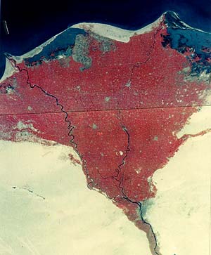
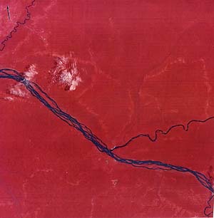
As the Nile runs towards its source in central Africa, it passes through the Republic of Sudan and splits near Khartoum into the White Nile, seen here, and the Blue Nile to the east, off the image. The clay-surfaced land, with occasional dunes (bottom), can be tilled to support crops, if properly watered. Water drawn from the Blue Nile, derived from the Sennar Dam as part of the Gezira Scheme, provides abundant irrigation for very distinctive, elongated farms whose main crop is cotton, the prime export from the Sudan. The soils is sufficiently depleted of some nutrients to require crop rotation (usually to millet) during alternate years.
Many people, influenced by movies, visualize the African desert as never-ending sand dunes. This next scene, in south-central Algeria, is in fact a more typical expression of the Sahara Desert. In the lower left third is the Tademait Plateau, underlain by sedimentary rocks, and crossed by dendritic intermittent streams whose channels were cut during a wetter epoch in the Pleistocene. The land in the lower right is the Tidikelt, a barren gravel-surfaced plains. The upper part of the image is a segment of the Grand Erg Orientale, whose most prominent feature is the series of longitudinal dunes first established when the wind blew more from west to east than today. This whole region is almost uninhabited.
Africa conjures up an image to many as a vast dense jungle. However, most of the continent is ecologically either a savannah (brush and grasslands) or a desert similar to the type in the image just above. But, in the “Congo”, much of that region being in today�s Zaire, a true jungle - much like that in the Amazon - of continuous rain forest made up of teak, ebony, copal, palm, and cedar trees remains one of the pristine timber regions of the world, although deforestation is now underway. Here, this status is disclosed by the solid expanse of red (= NearIR) vegetation; usually the region is largely cloud-covered but this clear March 1973 scene is unusual. The large river crossing the scene is the Congo (renamed the Zaire) River; the large tributary is the Aruwimi. The Congo is 4370 km (2718 miles) in length, making it one of the longest on Earth; it is navigable far upstream.
This next scene covers part of northern Kenya in East Africa. The capital, Nairobi, lies at the right margin about one-third down from the top (it is a bluish area midst the red). The dominant feature running north-south through the right half of the image is the African Rift Valley, shown here in dark bluish-gray representing basaltic rocks. Notable are the many scarps caused by normal faulting as the rift develops and pulls apart. (See page 2-9 for another example of this rift terrain.) Small volcanoes dot the Valley. The lake at the bottom is Lake Natron, whose level varies seasonally, and as it dries leaves sodium carbonate deposits. The lake at the top of the Valley is Lake Naivasha. Relief in the region exceeds 1000 meters (several thousand feet), so that higher elevations remain forested whereas lower areas are near-desert. Rain around Nairobi up to 100 cm (40 inches) gives that area enough moisture to support crop farming, including coffee planation.
The African continent is mountainous as well. You saw the highest peak in Africa, Mount Kilimanjaro, a huge volcano, in the Game subsection. The Atlas and Anti-Atlas Mountains of northwestern Africa, seen on page 2-6, are a collision-fold belt similar to the Appalachians. In this scene, near the coast in southeastern South Africa, is a fold belt known as the Cape Ranges, a collection of anticlines and synclines running about east-west, and made up of Paleozoic rocks. In places, their elevation exceeds 1500 m (5000 ft). The dark reds associated these mountains imply forests that include evergreens. They block winds coming from the Indian Ocean (lower right) so that precipitation is “wrung out” over them (up 130 cm or 50 inches annually), leaving the interior (left) in a rain shadow that fosters a semi-arid desert flora. Along the top of the scene is the Great Escarpment, a steep cliff nearly 1.5 km (1 mile) high on top of which is a vast peneplain referred to as the Post-Gonwana Surface, dating from the Cretaceous Period. Elevations above the escarpment reach to 2400 m (8000 ft). The region is harsh for living, with low populations.
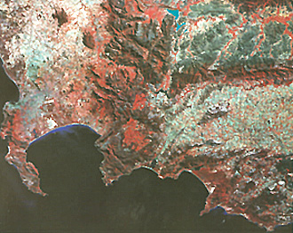
A continuation of the Cape Ranges carries one to CapeTown (blue area in center left) and the southernmost tip of Africa, as seen in this Landsat view:
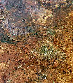
Finally, we show part of a MISR image that features the largest city in South Africa, Johannesburg, which lies in the heart of the Witwatersand - which contains the main gold-producing fields (numerous underground mines) on the continent: