LANDSAT TOURS THE WORLD
This Section is a change of pace, in which, rather than having to concentrate on heady ideas, we will simply take a pictorial tour across the U.S. and then around the world. We will look at Landsat and other remote sensing images, plus for the U.S trip some ground scenes, in order to “enjoy” a view of our planet�s land surfaces as though we were ourselves in the Shuttle or other space vehicle. The first page introduces several concepts dealing with the physiographic (geographic/geologic) provinces of North America.
LANDSAT TOURS THE WORLD
FLIGHT ACROSS THE U.S.: BOSTON TO SAN FRANCISCO
General Background
Enough of the heavy stuff for a while! Let’s take a breather, have some fun, and just look at some stunning scenes that depict typical landscapes and urban centers of the world.
The first part of this Section will concentrate on selected regions of the United States from the East to the West Coast. The second consists on representative views of other countries of the World, organized and displayed by continents beginning with the rest of North America, Central America, South America, Europe, the Middle East and Africa, and Asia.
We start by going on a simulated air vacation trip from one coast of North America to the other, and pretend we can look out over large expanses of the ground. In so doing, we will gain a sense of the variety of landscapes that make this one of the most diverse and interesting continents on the globe. We will accomplish this journey by perusing nine Landsat Thematic Mapper (TM) full scenes each typifying some specific region within the 48 conterminous states. Most of these scenes have been processed for maximum resolution and color balance by the Earth Satellite Corporation (a commercial group in Rockville, MD specializing in remote sensing services).
Many people, especially those who live near the East or West Coast of the United States, have flown on commercial aircraft across this country. Those who looked frequently out a window were certainly impressed by the ever-changing landscape. Each region has its own distinct character, expressed by combinations of topography, vegetative cover, and land use/cultural patterns. These characters are largely controlled by the underlying geology, climate, population densities, and particular modes of infrastructure development for supporting human activities.
Some of you have been introduced to these ideas and relationships, if you have taken a course in Physical Geography. One element or theme in that course is the importance of physiography, a term which connotes “description of the landscape” at regional scales that describes the types and influence of landforms, soils, climate, vegetation, and hydrologic actions on the natural scenery. It describes each region’s distinguishing physical character. Each realm is a discrete physiographic province, which, once lived in, seems unique, so that we always sense a distinctiveness in the surroundings when visiting a particular province. We show a map of the physiographic provinces in the 48 United States below:
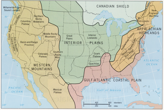
From H.J. de Blij and Peter O. Muller, Physical Geography of the Global Environment, Figure 52-1, 1st Ed. © 1993. Reproduced by permission of John Wiley & Sons, Inc., New York.
6-1: Locate (approximately) your birthplace and where you now live on this physiographic map. `ANSWER <Sect6_zanswers.html#6-1>`__
Five of the six mega-provinces in North America (excluding the Arctic Coastal Plains) extend into the U.S. Three national regions are subdivided by two or more provinces, as named. The Canadian Shield is part of the ancient craton or core of the continent and is marked by a dominance of Precambrian * igneous and metamorphic rocks, which give rise to low hills and subdued mountain ranges. Being in the north, the colder, generally humid climate favors dense boreal forests with evergreen and birch trees. The dominant mega-province in eastern North America is the Appalachian Highlands, consisting of several provinces, which contain rocks ranging in age from about 570 to 245 million years (m.y.) They have been involved in several major episodes of mountain building, culminating in the Appalachian Revolution about 250 m.y. ago. The oldest rocks in the east, many of which are metamorphosed and invaded by igneous intrusions, comprise the Piedmont province, consisting of rolling hills and ridges. The structural bending of Paleozoic sedimentary rocks into folds often offset by faults produces a distinctive topography of dissected ridges that generally are now less than 1,220 m (4,000 ft) in elevation. This area encompasses the New Appalachians, also called the Valley and Ridge province. The surface has been worn down, after uplifts over the past 10 m.y, to form valleys with rolling terrain. To the west of the province is a broad area of uplifted but unfolded sedimentary rocks making up the Appalachian Plateau province. Over much of this province, erosion has carved out mountainous terrain comparable in relief to the adjacent Valley and Ridge. Being in a humid, often warm climate the Appalachians are still heavily forested with deciduous trees except where cleared by humans for development.
The Interior Plains are underlain mostly by sedimentary rocks as old as 600 m.y. and young as 10-20 m.y. (in the western parts). These rocks are almost everywhere flat to subhorizontal, so that erosion has not carved out prominent mountain landscapes. The terrain is flattened further in the northern half by deposits from continental glaciers that covered the region during the last three million years. The Interior Lowlands seldom reach elevations above 460 m (1500 ft). They now support forests that remain after farmers cleared much of the land. These deciduous treescapes diminish to the west and south as grasslands take over. The Great Plains section consists of deposits of sediment brought eastward from the Rocky Mountains to the west. The deposits are piled up such that the elevations increase westward to 1525+ m (about 5,000 ft). Most of this land is either natural-grass rangeland used for grazing or farmland, with forests now being small and scattered.
In the southern U.S., but extending northward to New Jersey, is the mega-province of the Gulf-Atlantic Coastal Plain, a flat lowlands of nearly horizontal rocks, laid down in the last 60 m.y. as marine waters repeatedly invaded the North American continent during variations in sea level. This region is predominantly farmland, although some parts remain forested.
The Western Mountains are a number of diverse rock/structural units of differing ages and histories of orogeny (mountain-building). As we move westward, we notice the last major events are progressively younger. Because of differences in structural states, we conveniently break the eastern segment known as the Rocky Mountains, which can reach heights up to 4,420 m (14,500 ft), into three sections. The Colorado Plateau is an elevated (typically around 1,200 m [4,000 ft]) uplift of largely horizontal rocks, which have been cut into spectacular landscapes mostly covered with sparse desert vegetation. The Basin and Range province consists of rugged, often barren rock bodies uplifted along faults into elongated mountains separated by valleys with gentle sloping floors created by erosional fill from the higher ranges. Vegetation is mainly desert types that are scanty because of the rocky soils that dominate the surface. The Columbia Plateau is a region capped by volcanic flows (mostly basalts) extruded from fissures over the last 40 m.y. In places, the flat land is cut by deep canyons, but is also broken by older rocks sticking upward as pre-existing mountains that were not engulfed by the volcanic flows (which can be 1,200 m [4,000 ft] in thickness). The landscape in much of California and the western parts of Oregon and Washington is also mostly mountainous. The high Sierra Nevada is a great tilted fault block rising as high as 4,420 m (14,500 ft) and supporting fir and pine trees. It connects to the Cascades which are marked by numerous stratovolcanoes, more or less active in the last 20 m.y. Along the Pacific coastline are the Coast Ranges, still being actively warped by plate tectonic-driven compression. In California, between these mountain belts, is the Central Valley (subdivided into the Sacramento [north] and San Joaquin [south] valleys), a structural basin now receiving infill from the highlands. Its warm temperate climate allows extensive farming.
To provide you with a visual overview of the entire country, we display a mosaic of Nimbus Advanced Very-High Resolution Radiometer (AVHRR) false color images (see page 14-2 for a description of this sensor and its satellite platform).
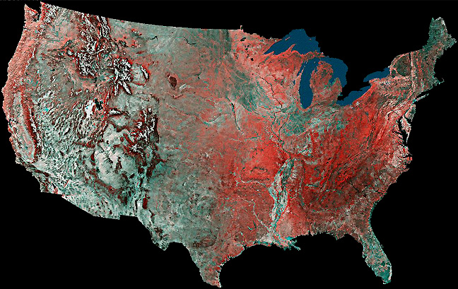
Alternatively, we could have reproduced one of several Landsat mosaics, such as the color versions produced by General Electric Corporation (for the National Geographic Society to celebrate the 1976 Bicentennial) or the first ever (in black and white) put together by the Soil Conservation Service. Because resolution is not a critical factor at the small scales we needed to portray the U.S. from coast to coast,we used the AVHRR mosaic. It required fewer individual images and we had fewer problems finding individual images that are cloud-free.
` <>`__6-2: This will probably prove more difficult, but again locate your birthplace and your current residence, if it is different, on this color mosaic. `ANSWER <Sect6_zanswers.html#6-2>`__
You may wish to get a better look at the space image appearance of your hometown or town where you now reside that affored by the U.S. mosaic. An AVHRR image and landform map of each state is accessible on a Web site produced by Applied Physics Laboratory of Johns Hopkins University in Maryland. To show you what to expect, here are the AVHRR and DEM topography (landforms) image you would get for the state of Wyoming.

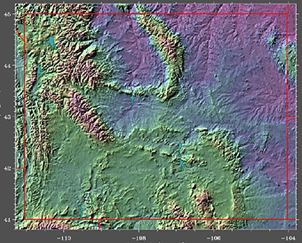
If you are interested in the geography of the features shown, particularly the mountain ranges, consult an altas.
* In several previous sections, here in Section 6, and later in the Tutorial, we use geologic time units routinely, such as the Precambrian. If you are unfamiliar with this chronology, and the Era, Period, and Epoch terms associated with it, you can examine a simplified time scale by clicking here.