The Four Corners Area: Colorado, New Mexico, Arizona and Utah
Contents
West of the main Rocky Mountain Belt, from northern Utah to northern Arizona, the colorful and varied landscape is controlled by the so-called Colorado Plateau physiographic province. It takes its name from the Colorado River rather than the state. Most rock units are subhorizontal sedimentary rocks but here and there are folds and uplifts that have punctured the plateau. Two Landsat images, accompanied by several ground photos, give the “flavor” of this flamboyantly scenic region.
The Four Corners Area: Colorado, New Mexico, Arizona and Utah
But it helps to examine the Plateau in the context of surrounding provinces. We saw much of the western United States in a HCMM image on the previous page. Now look at this even larger coverage found in a MODIS image:
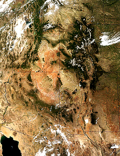
The central area with reds and browns make up the Colorado Plateau. Most of the Southern Rocky Mountains appears to the east. Part of the next province we will visit - the Basin and Range is displayed in much of Utah and Southern Arizona. The top of the image shows much of southern Wyoming which is commonly assigned to the Central Rocky Mountains.
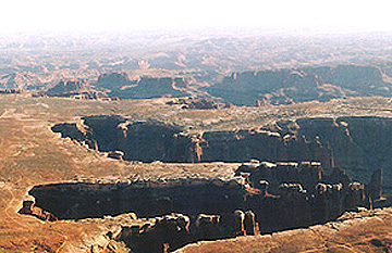
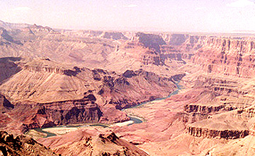
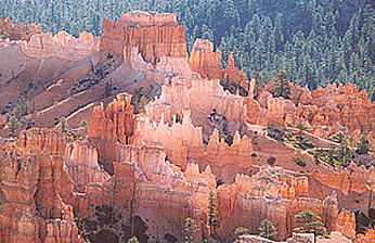
Many people consider this the most scenic of all provinces in the U.S. because of its marvelous landforms and its colorful rocks. Many of its mainly Upper Paleozoic and Mesozoic rock units are bright reds, oranges, and yellows, whereas others are light to dark gray to brown. To the southwest of this scene, the Grand Canyon; the most famous feature in the Plateau; exposes typical, multi-colored units. Bryce, Zion, and Canyonlands National Parks also display spectacular colored rocks. Here are three examples; check the caption for location.
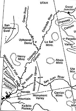
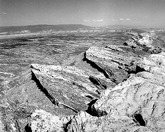
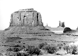
In Section 2, page 2-3, you have already examined in some detail one small area in the Plateau, the Waterpocket Fold. To help you visualize the landscape of this vast region, we show two ground scenes of characteristic features, first, the San Rafael Swell (see map), a broad dome, and second, the buttes that are so conspicuous in
Monument Valley, almost a trademark for that part of the country and site of many western (“cowboy”) movies, is a landscape dominated by buttes (prominences composed of flat rock stacks that are the remnants of stripping away of most of the higher layers from an earlier plateau cover).
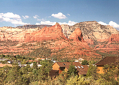
The writer’s (NMS) favorite spot in all of the western U.S. is along the Mogollon Rim (a popular locale for Zane Grey western novels) which makes up the southern edge of the Plateau. Seen below is Sedona, Arizona (about 40 miles south of Flagstaff), a huge tourist attraction and often used as a backdrop in TV commercials:
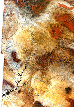
To conclude, we will concentrate now on just one Landsat image that includes parts of the lower right of the mosaic. The scene shown here includes the Four Corners - the only place in the U.S. in which that many
area.|
states touch each other at one point. Unfortunately, we can’t discretely identify the point, but it lies about 30% up and 15% in from the lower right corner of the image).
This false color image, taken in January, approximates some of these colors. At this time of year the sparse vegetative cover of sage, mesquite, and grasses does not produce a typical red signature, so that the surface tones are entirely those of rock and soil.
The Plateau rocks are almost everywhere still in the subhorizontal positions, in which they were deposited as sediments. Because they erode along steep faces or scarps, where cap rock is hard, the layers stack like steps to form plateaus, mesas, and buttes. The Gothic Mesas, just to the right of image center, are typical. Monument Valley begins near the lower left corner. The Plateau has participated in the general deformation of the West chiefly by uplifting without folding. However, Combs Ridge, a prominent monocline (like the Waterpocket Fold) is evident about 15-20% in from the left edge of the image. Near the bottom right corner are the snow-capped Carrizo Mountains, partially volcanic in origin, which rises at Pastora Peak to 2,870 meters (9,414 ft). These highlands blend into the Chuska Mountains to the south, just out of view..
This barren region has a very low population. Part of the scene includes the Navajo Indian Reservation. The small towns of Mexican Hat and Bluff in Utah lie along the San Juan River. At center left, this river has entrenched (deeply downcut) its meanders to produce steep canyon walls that make up the picturesque Goosenecks, shown in this photo.
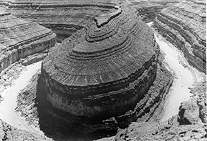
Just to the west of the image, the San Juan River joins the Colorado River, upstream from the artificial Lake Powell, formed by the Glen Canyon Dam. Finally, there is a “streakiness” in much of the lower part of the image. Prevailing winds, re-enforced by joint (fractures) control of landscape erosion, cause this effect.
` <>`__6-10: What causes “goosenecks”? `ANSWER <Sect6_zanswers.html#6-10>`__