The Great Plains
Contents
The vast central area of the U.S., into Canada, is a landscape of low, flat to rolling terrain in the Interior Plains that gradually rises westward up to 5000+ feet in the unit known as the Great Plains. Most of these plains are now converted land use-wise to farming. A typical Great Plains view of such country is shown by a Landsat image of Kansas. But, in various areas, especially in western North and South Dakota and eastern Montana, erosion has produce gullies and small canyons. A scene including part of the Black Hills is illustrative of this.
The Great Plains
As our journey continues to the west, the terrain slowly rises in elevation and local hilly surfaces, often with low scarps, begin to appear. In this next scene, also acquired in October, 1972 we are now
over the Great Plains of southwestern Kansas. During fall and winter, the ground has a grayish-brown look that intensifies even further to the west in Colorado. This is also evident in parts of this scene, wherever farm crops have not blotted out their underlying soils (i.e., currently fallow), or the natural surfaces are not converted to agriculture. An example occurs in the lower left corner where the Cimarron River has developed gullied badlands (dendritic drainage) in soft sediments. Note that many farms are square and are often just one mile on a side. These squares correspond to the section divisions in the Township-Range system of land mapping that was adopted in the 19th century in the United States. Near the upper right corner are clusters of circular pivot-irrigation fields, similar to those we showed on page 3-3. These fields lie along the Arkansas River just to the west of the largest town in this part of the state, Garden City.
As a generalization, the Great Plains scene appears similar to the Interior Lowlands scene, both of whch, are dominated by farmland. On the ground, the Kansas landscape has a more western look because of the semi-desert vegetation, including grasses and sage-like shrubs. There is more red in the eastern (right) half of the image than to the west, becauseof differences in crop type and stage. That is, wheat is more common in the western part of the image, and according to the harvesting schedule, the higher and somewhat cooler western lands had been culled earlier in the Fall.
There are few large cities in the Great Plains. Exceptions are Dallas-Fort Worth, which we examined in Section 4, and Kansas City, MO and Omaha, Nebraska which lie near the boundary between the eastern Great Plains and the Interior Lowlands. Here is a color photograph of Omaha, with Council Bluffs, Iowa across the Missourin River, taken by astronauts onboard the International Space Station:

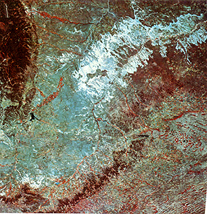
Where the western Great Plains extends into Canada, a visually striking difference marks the exact border between that country and the U.S., clearly evident in the scene below. The lower half lies within the farmlands (mostly wheat) of eastern Montana (note the elongate shapes of many farms). But across the border in Alberta, Canadian settlers chose to retain the natural vegetation (grasslands) and devote this land use to grazing of cattle (some farms are seen in the upper right). On the U.S. side, the plains surround two older outliers of igneous rocks, the Bearpaw Mountains (lower right) and the Sweet Grass Hills (center left), both forested.
It is surprising to some, especially after flying over the Interior and Great Plains, that the region from a broader perspective is not flat but often displays rolling terrain and distinct valleys. This is dramatically revealed in this next portrayal - a Heat Capacity Mapping Mission (HCMM; see page 9-8) Nightime Thermal Infrared view of nearly all of northern Kansas, most of Nebraska, and the southwest corner of Iowa. The Missouri (top) and Platte (center) Rivers control the major drainage. The sense of relief is brought about by the tendency of cooler air (darker) to sink into lower terrain at night, producing an effect somewhat like a shaded relief map.

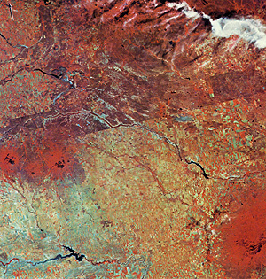
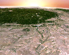
The Great Plains, which grades eastward into the Interior Plains, has a variety of landscapes, areas of which have few farms such as seen above. A typical example of a more diverse scene appears below. Most of the image is in western South Dakota. On the upper left is a portion of the Black Hills, which rise several thousand feet above the rolling terrain whose elevation exceeds 4000 ft (1100 meters). These mountains are so named because from a distance the preponderance of dark evergreens give the Hills a somber appearance. The Black Hills, home of Mount Rushmore and the Homestake Mines in Deadwood, S.D., are a broad domal uplift exposing igneous and metamorphic rocks over most of the interior. Geologists consider the Black Hills to be an offshoot of the Rocky Mountains, which we will encounter on the next page.
Almost due east is the famous Badlands (bluish-white), an extensively gullied area cut by erosion into soft, easily eroded Tertiary sediments. The medium-blue-gray areas are weakly dissected plains with sparse vegetation. This High Plains Tablelands is bounded on its southeast by the forested Pine Ridge escarpment. To the south is a farming region where wheat is the main crop, along with oats, corn, and fodder crop. At the lower right corner is the northwest end of the Sand Hills of Nebraska whose dune fields are discernible.
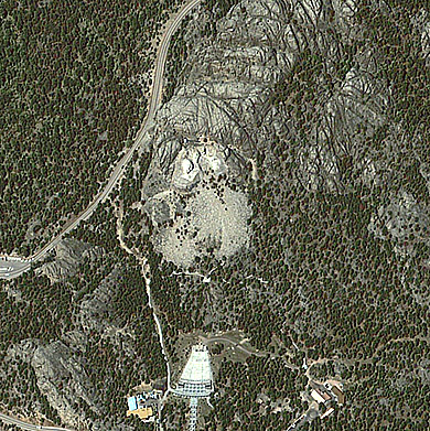
Here is a perspective view looking west at the eastern side of the Black Hills, made from Landsat and DEM data (note: the dissected high plains in the foreground contain the route taken by the writer [NMS] every day in the summer of 1950 when he worked for the Topographic Branch of the U.S. Geological Survey).
However, nowadays, in the mood of patriotism brought on by 9/11 and Iraq, the Black Hills have taken on a center stage position as we look back to our roots. On the side of a granite mountain south of Rapid City is the famed rock sculptures of the faces of George Washington, Thomas Jefferson, Abraham Lincoln, and Teddy Roosevelt - the Mount Rushmore Memorial - a National Monument. The writer (NMS) feels a personal kinship to this wondrous accomplishment by Gutzon Borglum and his son, Lincoln. I rented a room in 1950 from a Mrs Vincent. One Sunday she asked me to join some guests for breakfast. I was introduced to Lincoln Borglum and his family. Seems the bed I used was also used by Gutzon whenever he was in town as a respite from the construction site. The occasion this Sunday was the dedication of floodlights to illuminate the faces; the guest speaker was the columnist/radio commentator Drew Pearson whom I also met that night when I attended the dedication with the family. I’ve always treated this occasion as an honor and a lifetime highlight.
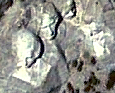
Thus, I was pleasantly surprised while cruising the Internet for new material to find a Quickbird image (2.4 meters multispectral combined with a 0.6 m panchromatic image) of Mt. Rushmore and the parklands around it. The DigitalGlobe people kindly made a copy available to me, shown below. I enlarged the area showing the faces of (as I remember) Washington and Jefferson. Most of my heroes are on this cliff (made famous in the movie North by Northwest but I wish that someone would add the faces of Ben Franklin (America’s most extraordinary and versatile Founding Father) and Harry Truman (my fellow Missourian who set the stage for the eventual check of Communism). Anyway, here are the images.
Compare this last image with a ground photo taken through a telescopic lens:
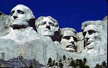
Incidentally, some have questioned the inclusion of Teddy Roosevelt in this quartet. Read his life: perhaps he’s not among the greatest (but high up), but few would dispute he is the most interesting as a “free spirit” personality.
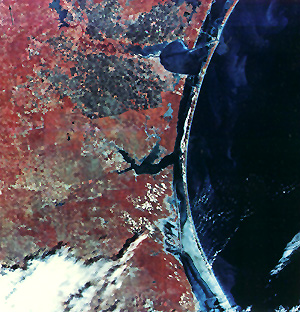
The next scene is not in the Great Plains but is topographically and ecologically similar to parts of the southern Great Plains in Texas. The region here lies in the Texas Coastal Plains, built up, as is nearly all the Coastal Plains province running from the southern U.S. to New Jersey, of Miocene to Pleistocene sedimenary rocks deposited when sea level was higher during marine invasion onto the continent. Corpus Christi is found along the side side of the Bay by that name (near top center). Almost the entire Texas coastline is one continuous string of barrier islands, with lagoons and the Intracoastal Waterway to its landward. Best known of these is Padre Island (top) which runs nearly the entire length of this scene. A vast amount of the land south of Corpus Christi was once a huge cattle grazing endeavor, the famed King Ranch, which still exists but has shrunk by sale of some of its holdings.