Australia and New Zealand
Contents
Australia is one of two “island continents” - so big that it is misleading to think of it as an island per se. Most inhabitants live along or near the coasts where nearly all its large cities are situated. Vegetation sufficient to stand out in the landscape is confined mainly to the southeastern corner and tropical areas in the northern sectors near the equator. Semi-arid and desert conditions prevail in most of the interior. High mountains are scarce; plains dominate. To the east lie the two islands of New Zealand. North Island has active volcanoes. South Island has a great mountain range, the Alps.
Australia and New Zealand
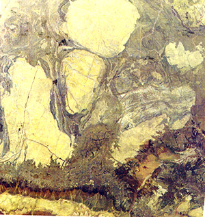
Most of Australia is semi-desert. Mountains are infrequent and relatively low. One region of low ranges and dissected crystalline and sedimentary rocks we will see again in a mosaic on page 17-3. But here we will look more closely at one of the images making up that mosaic. This is the so-called Pilbara District of northwest Australia, near the coast. In this image is perhaps the best single exposure on a denuded surface with little vegetation of the geologic phenomenon know as “batholiths”. These are intrusive igneous rock masses - often 100s of kilometers in dimension - that came as melt into the crust but did not reach the surface (until eventually revealed by downward erosion). Between these giant bodies are metamorphosed rocks containing basalts that are now called “greenstones”. This is probably the classic example of an Archaen Greenstone Complex, and especially of batholiths, anywhere on Earth.
Much of the Australian Interior is dry, harsh, inhospitable, and sparsely developed. This next scene lies in the Sturt Desert where New South Wales, South Australia, and Queensland meet. Numerous sand dunes aligned with long dimension running N-S blanket the landscape. Normally rainfall is less than 12 inches (30 cm) a year. But in this scene there had been a heavy period of rain a bit earlier such that water has collected (temporarily) in the low areas between dunes.

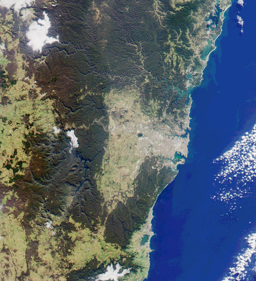
The dissected plateau country in southeast Australia receives much more rainfall so that the region is heavily forested with eucalyptus, gum, mahogany, and ironwood, as well as tree ferns, palms, and other tropical vegetation near the coast.The Blue Mountains and the Hunter Range make up part of the scene below. The largest city (more than 4 million) in Australia, Sydney, is developed between Botany Bay (south) and Port Jackson Bay (north) and extends inland at least 20 km (12 miles). This is how it appears in an Terra MISR image taken just before the Olympics 2000 began in September. The city itself is just right of center.
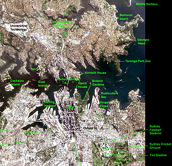
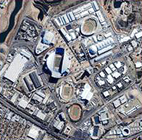
Zooming in closer on Sydney, look at this annotated EO-1 image of part of that great city:
When visiting Sydney in 1974, the writer (NMS) had a chance to tour its most famous landmark, the fabulous Opera House (while a performance rehearsal was taking place).

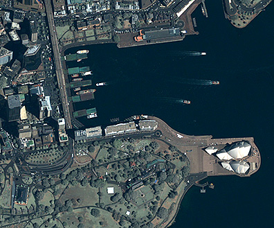
This marvelous structure, completed in 1972, shows up as a dominating feature in this online Quickbird image of the harbor and downtown buildings of Sydney. We have chosen this form of access as an option for you to see an enlarged version that shows the details of the scene rather than reproduce a smaller version on this page. However, we also extracted the Opera House area from that scene to display here:
The 2000 Olympic Village in Sydney (outside the edge of the EO-1 image) is sharply singled out by an IKONOS-2 image:
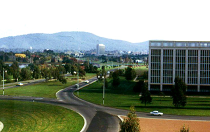
The writer during that visit was asked to lecture at the Australian National University in the new capital of Sydney. (At that time I was supposed to speak on the Moon rocks I had studied in 1969-70, but when I noted two world experts on the subject, Drs. Anthony. Ringwood and Ross Taylor, I lost my nerve and switched the topic to “shocked rocks” about which they knew little. In 1974 this newly built capital complex had wide open spaces and a still small population. Everything was built around a central lake. Here is a photo I took:
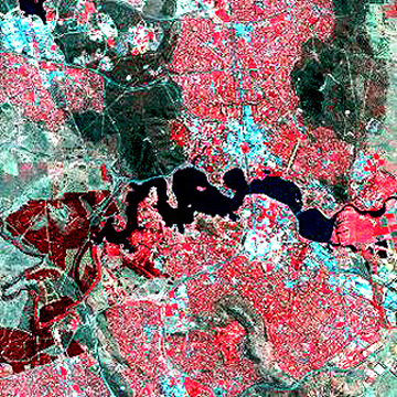
By the time (mid ’90s) this Landsat TM subscene shows considerable population growth and spread, as the city itself also by then had many planted trees in full growth.
We look last at southwest Australia, at an area about 725 km (450 miles) east of Perth and 160 km (100 miles) inland from the south coast. It is underlain by ancient Archean crystalline and sedimentary rocks that have been worn down to lowlands (plains).Natural vegetation is known locally as mallee scrub, a mixture of saltbush and bluebush. Most of the upper right has been undeveloped but over the years, much of the remaining area has been cleared by burning. Calcium-rich soils there, plus a rainfall of 25-38 cm (10-15 inches) per year, have favored development of numerous interlocking large farms. Wheat is the principal crop. Here in October (Australia�s spring), the fields show only the first stages of growth. Between the farmlands and the pristine terrain to the northeast is one of Australia�s electrified “rabbit-proof” fences designed to keep that marauding pest away from the croplands. Salt lakes appear in the virgin lands.

One of the most beautiful and scenic countries in the world is New Zealand, a pair of islands some 1600 km (1000 miles) southeast of Sydney. These landmasses form near a major plate boundary between the Pacific and Indo-Australian plates. North Island is notable for its several active volcanoes and a major geyser-hot steam field. But to those who have toured N.Z., South Island is ranked as even more striking because of its spectacular mountains and lush plains. The snow-capped Southern Alps, a chain of complexly folded and metamorphosed rocks elevated by plate collision to current heights above 3000 meters (10000 ft). Their western side is bounded by the great Alpine fault, analogous to the San Andreas of California (and many visitors compare the landscapes of N.Z. to parts of that state). The entire South Island has been embraced in a Day-IR HCMM image (see page 9-8), shown next, in which many of the black patches are snow. Note the effect on the regional topography by the Alpine Fault.
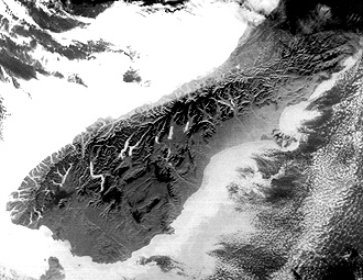
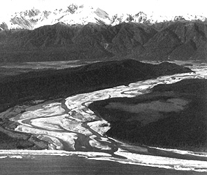
The Alps have been extensively glaciated, producing the rugged peaks and valleys walls that resemble Yosemite in California. As evident in the scene below, the eastern Alps give way to the Canterbury Plains, across which flow (top to bottom) Waiau, Waimakariri, and Raikaia Rivers. The Banks Peninsula to the east is built up, in part, of several now extenct volcanoes. The city of Christchurch (blackish area) lies at its northwest end. Land use is mainly sheep and cattle husbandry, and wheat, oats, and fodder farming on the Plains.
Alps of South Island in New Zealand.|
The kinship in appearance of the New Zealand Alps to those in Europe is evident in this Landsat 7 ETM+ image that shows Mt. Cook, at 3754 m (12316 ft) the highest point in this mountain chain, and almost twice as high as the highest mountain in nearby Australia the ranges on the two islands were once connected before New Zealand split off).

The ground photo below was taken from the coast north of Christchurch looking at the terraces in the Canterbury Plains cut by the Karangama River with the high Alps in the background.
Movie-goers, and especially fans of the Lord of the Rings trilogy, should recognize this scenery. The entire Ring was filmed mostly in South Island of New Zealand, but with some scenes in North Island.
As one moves out into the great Pacific Basin beyond Australia and New Zealand, many island groups are found scattered about, mainly in low latitudes. Many islands are volcanic (Hawaiian Islands the lead example). Some of those have fringes of coral around them. In this latter category, the third largest island is New Caledonia. This photo, taken by an astronaut aboard the ISS, shows a part of the island with its peninsula that contains the largest city, Noumea.

With these last scenes, we conclude our odyssey around the fascinating landscapes and urban centers on our planet Earth.