Europe II
Contents
Europe II
Now, as we head north, let’s take a glance at the head of the Adriatic where the canal city of Venice is located. First, to set it in context to the mainland, examine this ASTER image.

Then, we move a bit closer to look at Venice and the Mainland (Maestri) as seen by IRS-1:

Then, this is how the astronauts on the International Space Station saw the islands that include Venice proper, with north to the right.:
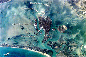
Here is a closer look at Venice as imaged by ESA’s PROBA; the Rialto and the Grand Canal stand out:

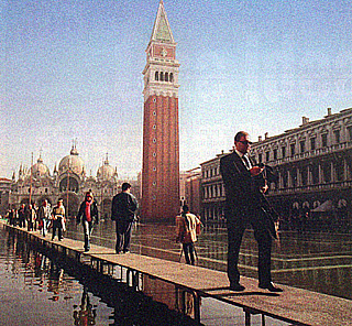
Venice, a city founded in the 5th Century AD, is now under serious threat of being gradually inundated by the Adriatic. Rise in sea level and a slow sinking as ground water is withdrawn from the islands are causing a rise in water level by an average 3 mm. a year. In recent years this has led to flooding of the Piazza San Marco by as much as 60 times a year, as shown in this photo;
Various solutions to save the main island are being tried: pumping water back into aquifers; sealing off ground floors; putting floodgates to prevent water from the Adriatic entering the lagoon during high water and storms; replanting stabilizing eel grass on mudflats; deepening the lagoon. But if global warming brings about the threatened major rise in sea level, Venice proper may become a city in the sea rather than by the sea. Plan your visit soon.
We have already explored the tip of the Balkans in the detailed consideration of Athens in the Answers to the Quiz in this Section. Now we will look to the north of Greece at a Terra MISR image of the southern part of Yugoslavia:
|Terra MISR image of parts of Serbia and Montenegro, along the Adriatic coast; the lake-like blue area just in from the coast is the Bay of Kotor. |
Several of the major cities in this southeastern part of Europe are now shown. The first two are Zagreb, the capital of Croatia, and Belgrade, the capital of the now shrunken Yugoslavia which had included Croatia, Bosnia, Serbia, Slovenia, and Montenegro in its larger post-World War II status.

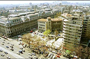
To the east is Romania (initially a province of Imperial Rome, which accounts for the latin influence in the Romanian language). Its capital is Bucharest, shown here in a Landsat image:
Although damaged during the Second World War, much of the city escaped serious damage. It has grown now into a modern city:
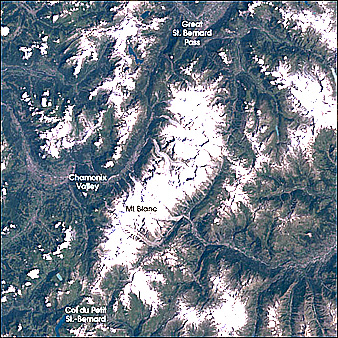
We next want to look at the most majestic mountain scenery in Europe - the Alps, first with a quicklook at the highest mountain in the Alps, in France, then at all of Switzerland and finally, in some detail, Austria. In the Landsat 7 ETM+ scene below is much of the French Alps (one of the images (Item B) in the Quiz of Section 6 showing the Rhone Valley includes this region as well). In this image is the famed Mt. Blanc (4807 m; 15707 ft) first climbed in the 1870s.
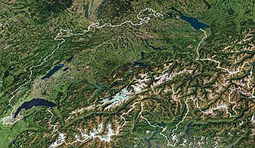
The next scene in a space imagery mosaic of all of Switzerland, which upon seeing surprised this writer (NMS) by the proportion (upper half) of that country consisting of lowlands and low mountains, something he did not fully appreciate during his several trips to that country (with my penchant for alpine vistas, I headed south with alacrity):
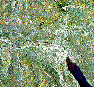
The largest city in Switzerland is Zurich, located at the north end of Lake Zurich, not far from the German border. Here is an ESA SAR image of the city and low hills around it. The black lines at the top are runways at its airport; these appear dark here because they act as a specular mirror when radar waves strike them, thus giving a minimum of backscatter.
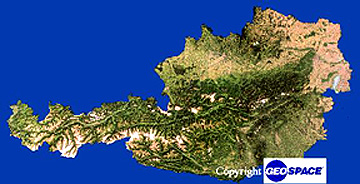
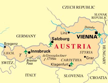
A similar-type mosaic presents all of Austria, with mountains everywhere except to the north and east of Vienna (Plains of Hungary). Below it is a map of Austria showing the principal citis.
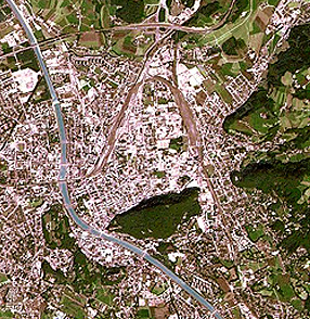
First we visit Salzburg in central Austria. Here is a high resolution space view of this charming small city set in a valley drained by the Salz River.
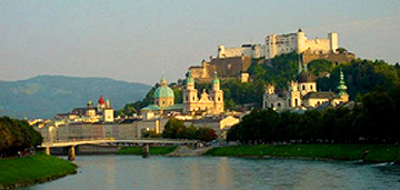
Here is a photo of the city of Salzburg, famed for its music festivals honoring Wolfgang Amadeus Mozart, born there in 1756 (he actually hated the town, partly because of its provincialism but mainly because of his servitude to the unappreciative Archbishop Collaredo). It was there in 1960 where I heard Mozart’s “Marriage of Figaro” in the Festspielhaus, given by the finest cast I’ve encountered in the many opera performances I’ve attended.

This photo shows the castle on a promentory and the Cathedral below. Many should remember it from the wedding of Maria and the Baron von Trapp in the “Sound of Music”.
Then on to Vienna, for several centuries the music capital of the world that attracted such classical notables as Joseph Hadyn, Wolfgang Mozart, Ludwig von Beethoven, Franz Schubert, Johannes Brahms, Johann Strauss, Gustav Mahler, and Arnold Schoenberg. Here first is a Landsat overview:

The city itself (blue area) lies along the Danube River at the tip of the Austrian Alps - location of the famed Vienna Woods. This next image is an IKONOS detail of the central city, lying within the broad streets which tie together as the Ringstrasse:

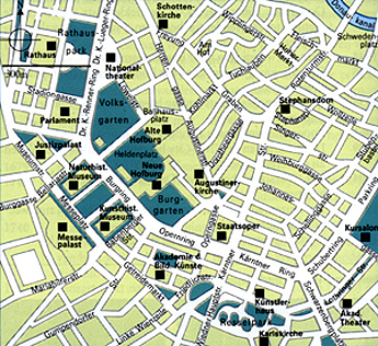
Below is a map of this part of the city:
Here is a panorama of Vienna seen looking west from the Danube River, with the Vienna Woods hills in the background:
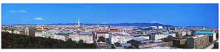
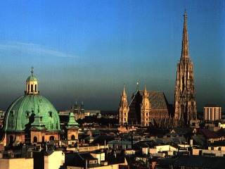
In that view is a high steeple. This is St. Stephens Cathedral, at 405 feet the highest point in the city. The next scene shows that Cathedral with the AugustinaKirche in the left foreground:
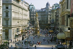
A walk through the buildings of Old Wien gives a flavor for the medieval part of this city.
Finally, one of Vienna’s most famous building’s - the Opera House on the Ringstrasse. The building we see below is an almost exact copy of the 19th century original edifice that was destroyed by bombing in the Second World War and then rebuilt as a duplicate. It was here in 1986 that I spent $100 U.S. for a ticket to hear Bizet’s Carmen - the biggest splurge in my musical life.

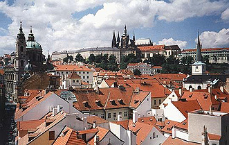
Several hundred miles northeast of Vienna is the picturesque city of Prague, now the capital of the Czech Republic. When the writer (NMS) visited it in 1968 it was part of Czechoslovakia, but the eastern half has separated into Slovakia. Here is a SPOT view of this city:

Add to this a Quickbird-2 image of part of Prague at 4 meter resolution:

A feel for the scenery of this lovely city is offered by this ground photo of the Prague Castle and the St. Vitus Church:

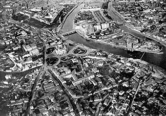
My wife and I were visiting Prague as I participated in the International Geological Congress held in this city. This was the time of the “Prague Spring” when Alexander Dubcek was leading his country into a rapprochement with their Soviet masters. Tensions were high. On the night of August 22, 1968, being a light sleeper I was awakened by a loud noise sounding like a low flying jet aircraft. This was repeated thrice in the next 5 minutes. I woke my wife saying “Wake up, we’re being invaded.” I was right. Troops from the Soviet Union, Hungary, and Poland had been ordered to occupy Czechoslovokia, their East European Bloc member state, to put an end to the Czechs’ bid for some freedom. We stayed up the rest of the night listening to Radio Prague as it tried to warn the people. The next morning we were greeted with this scene from our Hotel Europa window:
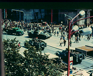
The Congress ended abruptly and I never really toured this enchanting medieval city (but my wife did). After two more hair-raising nights (one with hundreds of automatic weapons fired at some resisters in a building across the street), we were finally evacuated to Nurnberg on a train that carried 1400+ internationals (its capacity was 640 passengers). The normally 5 hour trip took almost 12 hours.
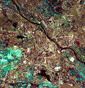
Among troops of the Warsaw Pact that invaded Czechoslovakia were soldiers of the Polish Army. Warsaw, the capital of Poland, was devastated by the German occupation Army and then the Soviets during all of World War II. It has since been largely restored. Here is an ERS SAR view of modern Warsaw.
A sense of how modern most of Warsaw now appears is given in this wide-view (panoramic) camera photo (scroll right to see its full extent):

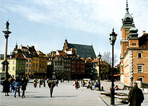
But the Poles were careful in rebuilding their city to maintain and restore the Old Town. This photo shows the Plac Zamkowy (a castle on a square).
To the northeast lie the Balkan States of Lithuania, Latvia, and Estonia, now independent countries after the demise of the Soviet Union. As typical of their cities here is Riga, capital of Latvia.
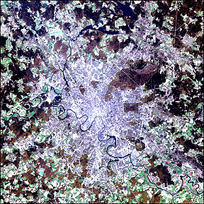
We now swing eastward to Moscow, the capital of Russia (where the decision to invade Czechoslovakia was finalized), revealed in this snow-covered (late February, 1974) scene because it is a “heat island” even in winter, so that the streets are mainly cleared. The many dark patches spread across the countryside are copses of evergreen forests, mixed with deciduous trees. Between them are open fields cleared for agriculture that includes rye and oats for food, flax for fabric, and feed for dairy cattle. This alternating interspersion of woods and farmlands must have proved daunting both to Napoleon in 1812 and Hitler in 1941 in their ill-fated winter attacks on Moscow. The large “river” north of Moscow is actually the 130 km (80 mile) long Moscow Canal, a manmade channel designed to connect the Volga headwaters with the Moskva River.
Let’s zoom in on the city and its environs as imaged in Spring by Landsat-7s ETM+:
The center of Moscow is the Kremlin Triangle, which includes Red Square, scene of massive military parades each October during the Soviet Era. Here is a view of that area.

And next is part of the city along the River Moskva.
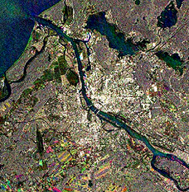
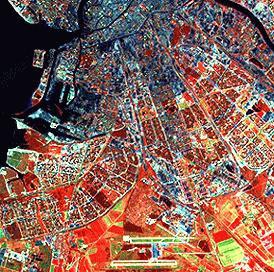
To wind up this extensive excursion across Europe, we will look closer at the image found on the top of the Geography Quiz page in this Section. There, we saw St. Petersburg (to most older readers, once known as Leningrad) in its regional context. Now, we examine it close up as imaged by the Indian IRS-1 satellite:
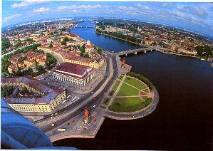
The tie between St. Petersburg and the Neva River is shown in this aerial photo.
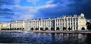
The most famed building in St. Petersburg is the Hermitage, once the Winter Palace of the Czars, and now one of the great fine arts museums in the world.
Europe, the center for western civilization for 2500 years, is well worth our time spent on this page. But, on to the next page which covers parts of the world which in central Africa and Mesopotamia is truly the “cradle of occidental civilization.