Life on Mars?
Contents
In the past five years renewed interest in Mars exploration, in antipation (or hope) that it will become the next big planetary goal for NASA and the worldwide space community has shed much new light on the Red Planet. The possibilities of significant amounts of water in the martian past, and some still extant even now, excite planetologists because H:sub:`2`O is a necessity for life. Some evidence of microscopic life forms in meteorites known to come from Mars is claimed but this still engenders strong debate. Further exploration of Mars has become almost a crusade for the NASA milieu and other martian devotees. This is underway with the successful Mars Global Surveyor and Mars Pathfinder programs, reviewed here. In early 2002, another spacecraft, Mars Odyssey, began taking data that provides maps showing thermal state and composition of selected elements, including hydrogen, on the martian surface. These recent satellites and landers have also greatly improved surface geological and topographic mapping and crustal thickness estimates. The page includes a look at future plans for visiting Mars. This page also briefly treats the two tiny martian moons.
Life on Mars?
The importance of those landforms with fluvial signs looked at on the previous page is that they suggest a probability that water did (does?) exist in sufficient volume and concentration on Mars as an essential ingredient for the inception of organic molecules. Carbon, the other vital constituent, was certainly present as indicated by today’s atmosphere. Whether these elements came from the interior or from meteoritic matter, during the accretion phase or later, is still uncertain.
The absence of any viable organics in samples analyzed at the Viking sites does not disprove the possibility of biogenic forms in modern Mars. The sampling may not have encountered organics at these two isolated sites but they dwell elsewhere. Both sites were in younger terrains, so the nonoccurrence could mean that any earlier life or unorganized organic matter had perished by then. However, one of the Viking investigators, Dr. Gilbert Levin, has always contended that there is indirect evidence of organic matter extractable from the measurements made onsite and transmitted to Earth.
Before (or after) reading through this subsection, you may wish to look over these four Web sites:(1) (2), (3), and (4).
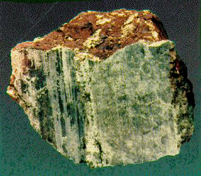
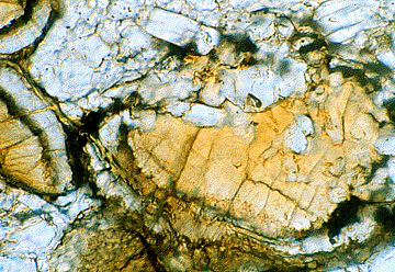
For the time being, an alternative approach would be to find meteorites on Earth that can contain strong proof that they came from Mars, being ejected through impacts into Earth-crossing orbits until a few pass onto the Earth. Such meteorites almost certainly now have been found. These form a group known as the SNG meteorites (consisting of the Shergottite, Nakhlite, and Chassignite types). They compositionally are similar to dunites, lherzolites, clinopyroxenites, and basalts. Some show several shock features noted in basic igneous minerals, indicating that these were close to the impact points on Mars; others without shock effects represent samples derived further from these points. At least 12 such meteorites had been found prior to the 1980s. This is a thin section that shows the characteristic minerals in a Chassignite:

Several lines of evidence support the martian origin postulate: One is the similarity of composition between the SGN group and inferred rock types at the two landing sites on Mars described below. Examine this plot, which shows several SGN meteorites (in orange letters) falling within a compositional field notably different from the two common terrestrial basic igneous rocks:

Other evidence includes isotope compositions that do not fit terrestrial or main belt meteorite rock types. A very strong proof is the almost identical composition of gases found in a Shergotty meteorite with gases sampled on Mars, as shown in this plot:

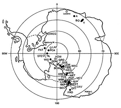
As mentioned elsewhere in this Tutorial, the number of meteorites being found annually went up very significantly when by the late 1970s Dr. William Cassidy of the University of Pittsburgh and successors determined that these “stones from heaven” could remain for long periods of time on the ice surface of the Antarctic. Many such rocks have since been collected. Included in these are some 35 SGN types, found at the locations shown in this map.
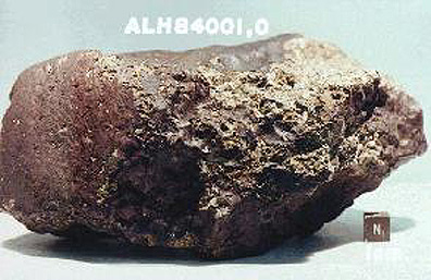
The sensation in the scientific world during 1996 was the claim that a meteorite from Mars, found in the Antarctic, contained evidence of life. It is known as the Allan Hills meteorite (ALH84001), which is characterized by containing orthopyroxene, has several features interpreted as consistent with organic structures found in some ancient terrestrial rocks. So far, only this Orthopyroxenite contains strong (but not conclusive) signs of organisms but several others contain tantallizing objects of possible biogenic origin. Below is this Allan Hills meteorite (one other has also been collected there) first as it appears before being sawed into (the black coating is glass [probably impact-derived]) and the second shows the rock after being halved, exposing its inner materials.
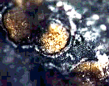
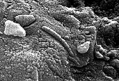
This fragmental rock contains dark materials, thought to be old martian crust, that date from 4.5 billion years ago. Golden-orange carbonate globules, dated at about 3.6 b.y., are considered evidence of a primitive ocean or in another interpretation weathering of surficial rock through reaction with the CO2 in the atmosphere. Here is an electron micrscope image of two Mg-Fe carbonate balls found in this meteorite:
A thin section of ALH84001 also shows the orange carbonates and orthopyroxes (clear):
Fossil-like bodies consisting of the iron oxide magnetite and iron sulphides are present, as seen at high magnification under the electron microscope.
Even more lifelike in appearance is the elongated chain of tapering magnetite crystals seen below, an arrangement known to be produced on Earth solely by certain bacteria. Some scientists hail this as convincing proof of martian life, formed very early in its history.

Associated with the globules are small amounts of polycyclic aromatic hydrocarbons (PAHs) that, while not necessarily biogenic, are interpreted by some as indigenous to Mars rather than contamination after Earth-arrival.
A second Antarctic meteorite, EETA79001, contains carbonate (suggesting martian sediments) and organic matter. This is anomalous in that both it and ALH84001 are volcanic rocks.
Needless to say, many skeptics have argued that this evidence is not persuasive; some similar features found in Earth rocks were inorganic. A recent report now claims that these tiny forms are indeed primitive bacteria but very similar to types still thriving on Earth; the implication is that this is just terrestrial contamination.
However, the possibility that they are genuine remains: if we certify life on Mars, the Earth would no longer retain its unique status as the living center of the Universe; although it is a huge leap from microscopic primitive organisms to the intelligence that then understands them. Suffice to comment that some scientists are touting these meteorite “life forms” as a pressing reason to formulate and accelerate a major space effort to return to Mars for more detailed exploration.
19-45: What would be the best proof of life on Mars? `ANSWER <Sect19_answers.html#19-45>`__
Resumption of Martian Exploration
After a 20-year hiatus in Mars exploration, the quest for onsite information about our red neighbor has resumed. Several of these are described at JPL’s Missions sites (Current comes up, check also Past and Future). First up was a launch in 1993, of the Mars Observer, a billion-dollar spacecraft, which, regrettably, failed enroute. The Mars Global Surveyor MGS) followed on November 7,1996, with its operation directed by JPL. The spacecraft arrived for orbital insertion on September 12, 1997. In December of 1996 the Pathfinder mission was underway, to land a roving vehicle capable of viewing the local terrain and making sophisticated measurements. An orbiting spacecraft, whose task is mainly climatic measurements launched in mid-December of 1998.
From an initial orbital altitude of 400 km (249 mi), the Global Surveyor used the aerobraking technique, which involved progressive slowing through air friction (drag) with the thin atmosphere, until, after six months, the spacecraft lowered to 110 km (68 mi). >From there, using thrusters to maintain this altitude, a mapping mission began in late-March of 1998 to last a minimum of 687 Earth days. A second lowering was executed in 1999.
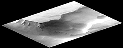
The Global Surveyor has a wide- and narrow-angle camera system (MOC or Mars Orbiting Camera), the Mars Orbiter Laser Altimeter, a Thermal Emission Spectrometer to measure atmospheric heat and surface composition, a Magnetometer/Electron Reflectometer, and two other instruments. Among the first surface images, taken from the higher altitude in early October of 1997, are these two examples of the many views from the mission. The top image (175 km; 108 miles) is of a section of Labyrinthus Noctus, a maze of interlocking grabens. The bottom image is 12 by 12 km; it shows a canyon wall in an unidentified area of Mars.
This next image is not a computer-generated perspective of the right image above, but was taken from MGS when its MOC was tilted 25° towards the horizon so that the view of the canyon walls is an actual scene with a 12 meter resolution, even though the target view is 1600 km (1000 miles) away.
The Mars Orbiter Camera (MOC) can take pictures with resolutions of 3 m (9.8 ft). This resolution will improve slightly over time, as the orbital height lessens, because of the aerobraking effect. A very large number of these images can now be viewed online at the Malin Space Sciences System site - this is certainly worth visiting now that they are putting up a new image each day. Several of the images shown below are credited to NASA/JPL/Malin Space Sciences Systems (referenced by MSSS).
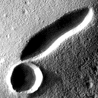
The next view (MSSS), taken after the orbit lowered to the altitude chosen for the first major scientific measurements, shows details of the terrain surrounding an elongated volcanic caldera, 2 km in length in the Tempe-Marcotis Fossae region. Almost touching it is a round crater that may be impact in origin. The surface surrounding these two features is marked by small dunelike features probably built up by wind action
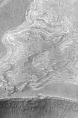
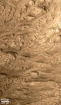
Layering of the bedrock of Mars (presumably either lake sediments or dust beds or volcanic flows) has been imaged at several martian locations. Here is an MOC view (MSSS) at 7 meters resolution of the wall of Candor Chasma in Valles Marineris that shows distinct layers.

` <>`__19-46: What can you say about the layering seen along the left facing cliff in the right center of the image? `ANSWER <Sect19_answers.html#19-46>`__
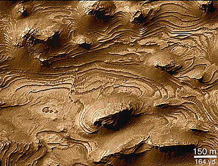
Many Mars investigators, including Dr. Michael Malin, assert views such as above as unequivocal evidence for layering. Examine this view (MSSS)of another part of Candor Chasma:
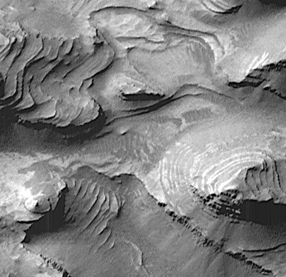
Note that the so-called layers are arranged stepwise in terrace or benchlike patterns in part of the image. Such offset “layering”, if this it be, is sometimes found associated with mesas in the horizontal rocks of the Colorado Plateau. In the butte-like prominence at the center right of the image, the layers are well exposed along the steep sides. Two more MOC examples further support the presumption that this layering is sedimentary in nature; the precise mode of deposition is still being debated, with the two favored choices being either lake beds or volcanic ash deposits from cyclic eruptions. The first image occurs in the Juventae Chasma region; the second in West Terra Arabia.

Units that are almost certainly layers have been exposed at the West Terra Arabia Crater as seen in these MOC images. Here the layers appear inclined or dipping; but in an image from the crater center they look more horizontal, as expected if an impact crater hits on a sequence of non-inclined beds, with the dips then caused by the cratering action (on Earth craters [e.g., Meteor Crater in Arizona] in horizontal bedrock will show strongly inclined and even overturned layers outward towards the rim). The left image is near the rim top. The right image is further down the crater walls and contains black deposits which could be shock-melted rock or black basalt sand brought in by the wind.
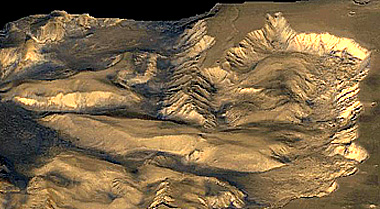
Eroded terrain, with horizontal beds, very similar to the WTA crater has been imaged by MOC in the floor of West Candor Chasma, as seen here:
The West Candor Chasma is a subsidiary canyon tied to Valles Marineris. This Viking image shows the rugged nature of the interior terrain:
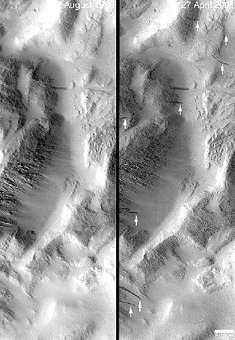
The MOC onboard the Mars Global Surveyor has been returning some provocative high resolution images that, after much interpretive debating, many geoscientists now believe offers supporting evidence of either water escape in the recent past or even indications of water still emerging. This MOC view below (5 m resolution) indicates channels coming from material in or below the edge of the southern ice cap. The stream outflow, if that is a valid identification, in each rill ends up with a small fan of deposits at its terminus - again, a feature consistent with fluid transport.
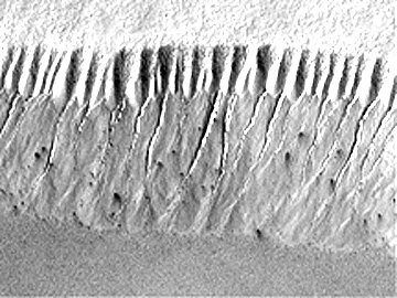
This Mars Global Surveyor image shows something unusual - what appears on the right to be a wedge of frozen ice cascading downslope. This has been interpreted to indicate that water moves at shallow subsurface depths and here extrudes at a canyon wall where is freezes (much like the ice sheets seen in roadcuts during winter). If so, this further supports the argument that the rills or gullies also seen in this image are water-generated.

The next three images (NASA JPL and Malin Space Science Systems [MSSS]) demonstrate how planetary geologists go about interpreting and reasoning to conclusions using imagery returned from martian satellites and probes. The argument to be devised uses Martian Global Surveyor data to examine the region illustrated in this topographic map:

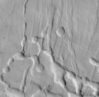
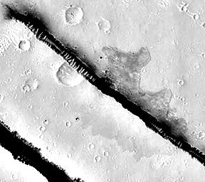
The Cerberus Fossa (channel) includes this 100 m wide, 10 m deep straight feature that, by comparison to similar areas on Mars, is almost certainly a tectonic graben, bounded by faults on either side expressed as steep walls. Emanating from the upper wall is what appears to be lava flows spread over both the flat land beyond the fault and into the graben floor.
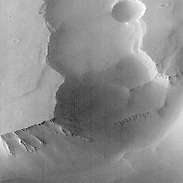
The Athabasca Valles extends southwest of the Fossa. It resembles a stream-cut valley similar to some on Earth. Within it is strong evidence of stream flow in the form of the streamlined, tear-drop shaped flatlands within it (see above on this page), such as shown here:
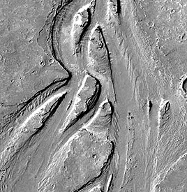
Water is presumed to have excaped from the Cerberus Fossa during, or at different times from, periods of volcanic activity. The amount of water needed to develop the valley is estimated to be about that found in Lake Erie today. Based on crater counts and other data, geologists believe that the principal valley-forming events may be as recent as 10 million years ago.
` <>`__19-48: What causes the numerous indentations found in several of the dark layers? `ANSWER <Sect19_answers.html#19-48>`__
The Ma’adim Vallis (white arrow) is a 2.1 km (6900 ft) deep cut into the Southern Highlands that runs from a topographically lower area to the Gusev crater. H. Irwin III, G. Franz of the National Air and Space Museum (NASM) and others have published evidence that the low area was once filled with water in several lakes whose extent, if on Earth, would extend across Texas and New Mexico. They have reconstructed these lakes (not now existing) by coloring the topographic lows blue against a Mars image of the region:
|Part of the Southern Highlands of Mars in which blue has been superimposed on topographically low terrain; a deep valley has been cut by overflow. |
In their model, at some stage in Mars’ past, the water from the central lake burst from its confines and rushed through the already forming valley, thus deepening it rapidly (analogous to the Scablands of the State of Washington; see above).
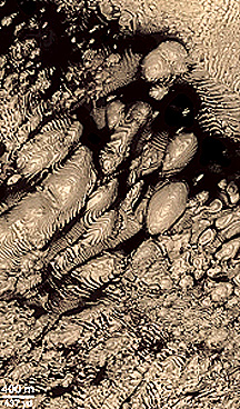
A new line of evidence for water and/or ice on Mars has come from MGS images of what is considered to be analogs to phreatomagmatic “rootless” volcanoes on Earth (especially in Iceland). Consider this image (MSSS) of a swarm of cones in the Cerberus Plains near the martian equator:
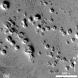
The origin of these miniature cones (typically, about 50 meters at their base) requires water to have been released at earlier times that becomes trapped near the surface (perhaps at depths of 3-5 meters). At the cold martian temperatures, this water is preserved as ice. Then, later eruption(s) of volcanic flows heat the water to steam, causing a pressure buildup that ejects material locally to build up the cones. The implication of the presence of these cones on what may be a young surface is that ice entrapment may occur within suitable martian terrains and could thus be available as a source of water during human exploration of this planet.
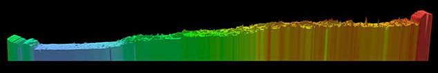
The Laser Altimeter (MOLA) on the Mars Global Surveyor yields maps and profiles that show martian relief. The southern hemisphere is, on average, 10 km (6 miles) higher than the younger northern hemisphere. This is brought home by this block diagram that shows variations in topography alone the 0° latitude running from the North Pole (left) to the South Pole:
The next figure is a flat projection map of the entire martian subpolar surface produced from a large number of orbital lines with data taken at every 60 km (37 miles) yielding 27 million data points. Vertical resolution is 13 m (42 feet). Highest elevations are shown in white, with progressively lower elevations in brown, red, yellow, green, and blue (lowest).
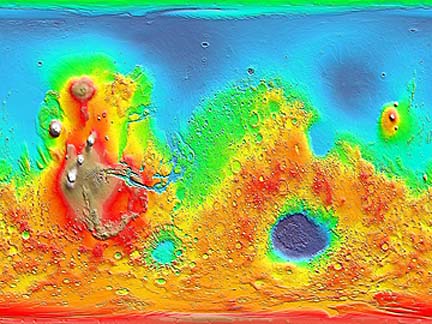
The maximum relief on Mars ranges to 30 km (19 miles), determined by Valles Marineris as the high point and the Hellas Basin the low point, about 1.5 times greater than that on Earth. The three white round areas are the Tharsis volcanoes and the offset white one is to the left. The brown rounded area above these is Alba Patera. Valles Marineris is obvious. The blue-green circular feature below is Argyre Planitia. The large elliptical blue region in the red southern hemisphere is a huge topographic depression about 2100 kilometers (1300 miles) is the Hellas Basin, so far is the biggest impact crater known in the Solar System.
MOLA on MGS.|
` <>`__19-47: Compare the relief (difference in elevation) between Alba Patera and Olympus Mons. `ANSWER <Sect19_answers.html#19-47>`__
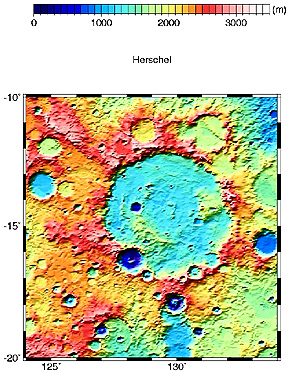
Still another example of a MOLA-based topographic map is that centered on the Herschel crater east of Hesperia Planum:
The topographic map of Mars, combined with gravity and other data, allow calculation of the general thickness of the martian crust, as shown in this global map:
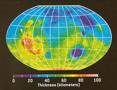
Thicknesses of the crust at major locations are estimated as shown in this Table:
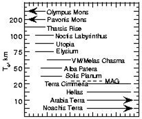
Note the fairly strong correlation between topography and thickness, emphasized here by using the same scheme of reds/orange for higher elevation/greater thickness and blues for lowest elevations/minimal thickness in the two relevant maps.
Another exciting and informative scene taken by the Global Surveyor combines a color view of the North Pole Ice Cap with topographic data obtained from a series of Laser Altimeter passes to produce this three-dimensional view:
The size and amount of ice (which the spectrometer confirmed was largely water ice) was less than anticipated from pre-Surveyor observations. The cap is roughly 1,200 km (746 mi) across (crudely circular) and as much as 3 km (1.9 mi) thick. With an average thickness of 1 km (0.62 miles), the volume of ice is about 1.2 million cubic kilometers (288,000 cubic miles), roughly half that of the Greenland Ice Cap on Earth. The cap’s general surface is quite smooth, but the ice cap is cut by large, deep (up to 1 km; 3,280 ft) steep-walled canyons and troughs, which may have come from cracks enlarged by wind and possibly meltwater. The amount of water located at the North Pole, and lesser quantities now at the South Pole, does not seem sufficient to have once made an ocean over parts of Mars. It instead may be the remnants of any seawater that could have existed in the Mars past. Any relationship of this surviving water to the river-like channels on Mars is still speculative. Water may be widespread even now but would be subsurface. Detecting that water is one of the objectives of future Mars missions.
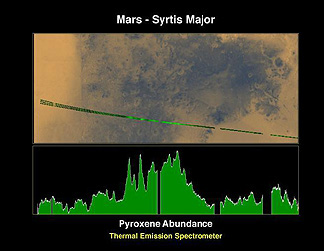
` <>`__19-49: Account for the area that shows the highest pyroxene content; why? `ANSWER <Sect19_answers.html#19-49>`__
MGS sheds new light on the famous “face” on Mars first noted in a Viking image and seized upon by zealots favoring a lost civilization on the Red Planet as an artifact carved (like the Sphinx) into bedrock. The left view is the Viking image; the center (MGS) view shows the feature to have several mini-mountain peaks partly responsible for the fortuitous shadowing that highlights the face; the right view is a negative of the center view that recreates the shadowing.
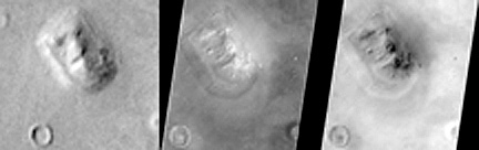
A more recent image of the “face”, taken by Mars Odyssey (see below) reveals an even more uncanny likeness to a face:

In this image, the rock promentory that looks like a nose even has a “nostril”. Surrounding the “face” is a blanket of material that resembles hair. Judge for yourself what this feature might really be.
An April 1999 report by Mars Global Surveyor investigators has created a flurry of excitement about an aspect of the martian crust which may be a counterpart to the mobile segments of terrestrial crust that are involved in the concept of Plate Tectonics - a cornerstone in our understanding of the operation of the Earth’s outer layers embodied in the idea of “continental drift”. The Mars Global Surveyor magnetometer has picked out a series of magnetic stripes on Mars that systematically reverse their polarities. Thus:
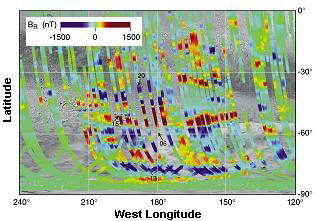
These martian strips are found mainly in the older terrains of the Southern Hemisphere. They trend at high angles to the polar axis. The implication is that this crust was formed by outpourings of lava from analogs to the terrestrial oceanic ridges that push the plates towards subduction zones (no such features have yet been recognized on Mars nor are there changes of mountains that result above these zones). This also suggests a much stronger magnetic field during early martian times; this would indicate a (partially) molten core. The full meaning of this new discovery is yet to be assessed.
Launched on December 4, 1996, JPL’s Pathfinder landed on July 4, 1997, in the Ares Valle near the earlier Viking 1 site . This shorter transit time (seven months) resulted from a better alignment of Mars and Earth in their orbits The primary scientific purpose of Pathfinder was to release the small Sojourner Rover, guided from Earth through the lander’s communication system. The Rover moved independently (after departing the lander down a ramp) up to 20 m away on its six, flexible, rocker wheels, to take pictures and bring its spectrometer against rock surfaces for analysis.
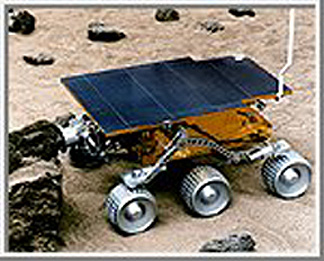
This microrover, which weighed 11.5 kg (25.4 lbs), measured the following: length = 630 mm (24.8 in), width = 480 mm (18.9 in), and height = 280 mm (11.0 in). Using power from a solar panel, Sojourner moved at a maximum speed of 40 mm/min (0.13 ft/min) during the martian day. Its front and back wheels moved independently to control its steering. The microrover used a stereo camera, mounted at its front, which imaged objects in its path. Each excursion was intermittent, because operators on Earth determined direction changes to reach target rocks and avoid obstacles. This took extended time periods because of the long distances radio and video signals traveled back and forth. When it encountered small rocks, the wheels raised up to glide over the obstruction.
The stereo camera system on the Pathfinder took images of the surface around the lander, obtaining black and white views and colored ones with color filters. Sojourner’s camera also collected images (mainly rock close-ups). Next, we show a panoramic montage of most of the surrounding site, in which we identify (using friendly names that speak a personal touch) some of the rocks that it visited.

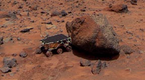
Many of the rocks are grayish on fresher surfaces. These surfaces appear weathered and pitted, and often are, at least partly, dust-covered. A typical large rock is Yogi (shown below), which appears to have a reddish dust blanket on one side and a sharp boundary with fresher rock (right side).
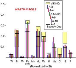
The primary instrument on the microrover is the alpha-proton-x-ray spectrometer (APXS). This instrument uses high speed alpha particles to bombard soil or rock surfaces. These particles generate a back scattering of alpha particles, alpha-proton particles, and x-rays, whose energies as determined at the detectors are indicative of a wide number of elements. It thus detects, quantitatively, elements such as those in rocks, i.e., Si, Al, Ca, Fe, Mg, K, Na, Ti, Mn, Cl, S, P, O, and C. It can report these elements in their elemental form or as oxides. The diagram below is a histogram of many of these elements from Barnacle Bill, Scooby Doo, Yogi, and some soil sites. Barnacle Bill’s composition is close to that determined earlier at the Viking site but the other rocks and soils are different.
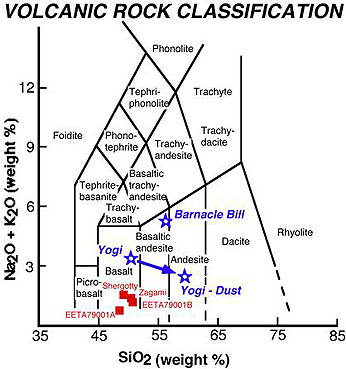
The next graph (top), is a plot of values of elemental ratios of Fe/Si and Ca/Si from the Pathfinder site, compared with certain Earth rocks. The Mars rocks are definitely not basalt. They plot close to but not within the compositional field of the terrestrial volcanic rocks known as Andesites. When we recalculate the elemental composition of the Pathfinder rocks into what petrologists term normative rock compositions, we see that the mineralogy is similar to andesites (bottom diagram).


But the presence of normative quartz (leftover silica, after we assign all other SiO2 to the other minerals), technically makes this rock type a dacite. Andesites and dacites are the common volcanic rocks emitted from continental volcanoes, such as those along the Ring of Fire (e.g., the Pacific Coast Cascades). The presence of these rock types at this martian site, if typical of other sites, suggests that the Red Planet had melted and differentiated, so that at least part of its crust is andesitic. Paul Lowman (author of Section 12 of this Tutorial) had postulated more than a decade ago that an andesitic primordial crust probably developed early in Earth history and may be the norm for other inner planets.
` <>`__19-50: Which rock should be darker: Barnacle Bill or Yogi? `ANSWER <Sect19_answers.html#19-50>`__
Most of the rocks plot in the basaltic and andesitic fields of a diagram which shows the classification of basic to silicic igneous (volcanic) rocks found on Earth in terms of NasO + K2O versus Sio2:
Interpretation of MGS and Pathfinder data, supplemented by that acquired later by Mars Odyssey (see below), has led to this general map of the surface rocks and sediment cover on Mars. Basalts are shown in green and yellow; andesites in blue, and regions where dust cover is so thick that data on underlying bedrock could not be recorded appear in medium tan:
Landers have gathered compositional data at three widely-separated martian sites (Pathfinder; the other two are the Vikings). In general, the sites are similar in their chemical makeup. This may simply mean that the martian crust is homogeneous, but even more likely is the explanation that martian wind circulation has scattered and homogenized compositional differences across the planet. The distribution of rocks and boulders at the Pathfinder site further supports earlier ideas that at one time in the Mars’ past there was considerable water cover and resultant flow currents, causing a pattern sometimes observed on Earth as flood-related.
The last Pathfinder image we show below is a classic sunset picture, taken through the thin, dusty, martian atmosphere that produced a fan-shaped glow around the distant Sun.

A series of spacecraft will be sent to Mars in the first decade of the 21st Century. The first, the Mars Climate Orbiter, was launched on December 11, 1998. but failed to reach its planned orbit. This was followed on January 3, 1999 by the Mars Polar Lander which apparently did not achieve a proper setdown, as no signal was ever received. There will be a series of Mars Surveyors launched in the next five years culminating in Surveyor 2005 which will gather samples for a return to Earth. All of this is connected with the (tentative) U.S. decision to eventually send astronauts to Mars, after it has been thoroughly explored with these probes.
One successful probe is Mars Odyssey, launched on April 7, 2001. Access its Home Page at JPL’s site. Because of the important discoveries it has been making, here is an artist’s rendition of the spacecraft in orbit around the Red Planet.
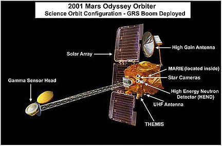
Odyssey was inserted into orbit on October 20, 2001 and has now aerobraked to descend to about 300 km from the planet. One of its sensors, THEMIS, a thermal infrared emission spectrometer, is surveying the gross mineralogy of MARS. GRS, includes a gamma ray spectrometer that will obtain compositional data covering 20 elements, in particular evidence of hydrogen that is tied with oxygen as water. There are actually three instruments in the GRS: the Gamma Ray subsystem, the Neutron Spectrometer, and the High Energy Neutron Detector (built by the Russians). In its fully operational mode, the GRS is located at the end of the boom (see spacecraft picture above) which was deployed in June, 2002, Here is one of the first results: a visible image and an associated thermal map, made from THEMIS data:
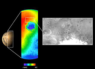
Bands 5, 7, and 8 on THEMIS were used to produce this color composite of Ganges Chasma in Valles Marineris. The scene is about 150 km (100 miles) on a side. Blues are correlated with basalts; the purples indicate a high olivine content.

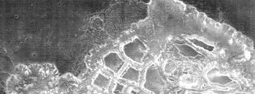
This next image from THEMIS shows a nighttime view of chaotic terrain on Mars. Note its similarity to nighttime thermal images shown in Section 9.
Referring to the GRS instruments, the principle behind production of neutrons from cosmic rays is illustrated here:
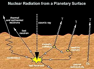
Incoming high energy cosmic radiation interacts with atoms in surface materials, generating fast neutrons which either directly escape beyond the surface to a detector or interact while leaving to be slowed to epithermal and thermal neutrons having lesser energies. The energy spectral distribution is a function of the elements involved. Note that gamma rays are also produced.
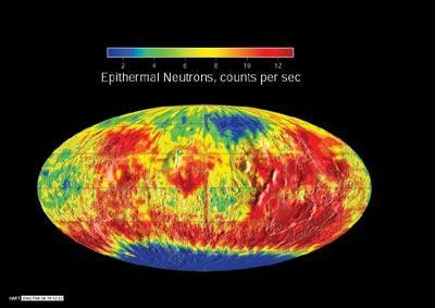
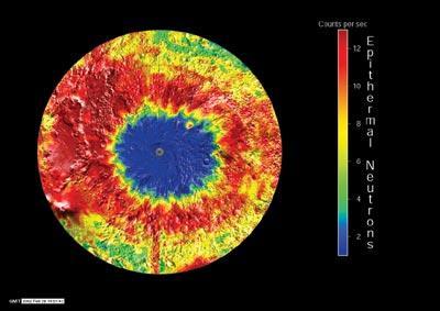
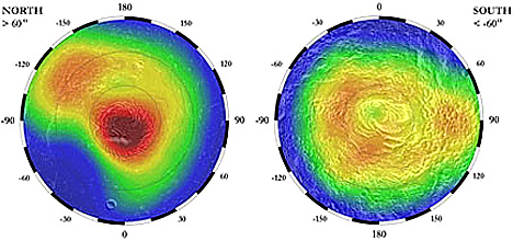
A preliminary map (top) of the global distribution of epithermal neutrons and a closer look at the South Polar region (center) appear below. A thermal neutron global map is displayed at the bottom. Blue indicates conditions explainable by high hydrogen content; hydrogen moderates (absorbs) neutrons better than the heavier elements. While several explanations could account for this, the most probable is hydrogen bound with oxygen as water. More observations will be needed to confirm this, but most Mars scientists favor the model described in the next paragraph.
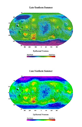
Maps made by the Neutron Spectrometer, released in December 2002, indicate even more potential water (higher hydrogen content in purple) than earlier announced. This pair of global martian maps shows the hydrogen distribution first when the south polar cap was largely free of CO2 and later when the CO2 had sublimated of the north polar cap and to some extent resolidified at the south cap.
A 2003 map based on neutron data from Mars Odyssey emphasizes the wide variation in water ice at the northern pole beteen martian summer and winter. This is displayed best when first the CO2 has sublimed off the cap leaving a dominance of the hydrogen-rich (low neutron count) substance whose identity is almost certainly water:
![Water variation (in terms of low hydrogen content [blue] at the northern martial polar region; as determined by Mars Odyssey.](../_images/marsfrost.jpg)
The Russians have produced a map of high energy fast neutron results which also show similar distributions of water:
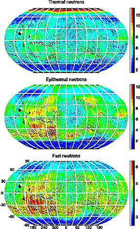
For close comparison, this diagram shows the general distribution of all three types of neutrons:
A recent map of regions with variable water content has now been published (below). Calculations indicate there is enough water present in rocks and soil near the surface so, if melted, the entire planet would be covered by water up to 10 cm (4 inches) in thickness.

As of June 20, 2003 no maps or data of the multi-element survey beyond hydrogen by the GRS have been released.
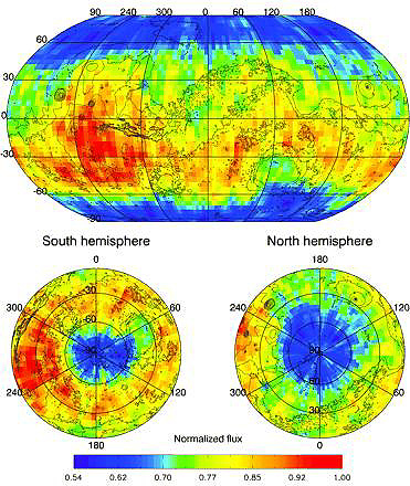
But improved water maps (based on hydrogen absorption of neutrons) continue to be released to the scientific community. The two maps below were displayed at an International Mars Conference at JPL in early August of 2003:

Both MOLA and MGS data are used in making these maps. Hydrogen data come from the neutron spectrometer on Odyssey. In the blue areas, the amount of water ice is between 2 and 10% (assuming that all hydrogen is present in water; hydrous minerals may contain both water and OH). Water increases to around 50% (yellows and oranges) to 70% (dark red to black) mainly around the poles; estimates approach 90% near the North Pole). But water highs are found in Arabia Terra and other areas at lower latitudes.
Thus, the current conclusion from these neutron data sets is that there is much more water at and just under the martian surface than had been anticipated from all previous hints from earlier missions. In the polar and high latitude parts of Mars, it appears that water ice is quite abundant in the top meter or so of the debris that seems to cover most of the planet. The layer may be similar to permafrost in terrestrial rock and soil materials in Alaska, Siberia, and other high latitude land cover. Some of this martian layer can be considered as an ice bed, with subordinate amounts of rock fragments. This may grade into a predominance of fragments cemented by subordinate water.
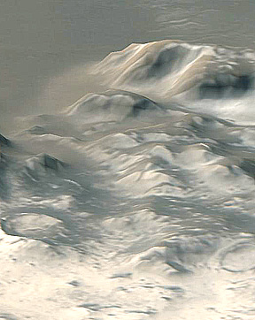
As indicated above, some ice seems to extend into the low latitudes of Mars. There may be both a permanent subsurface layer and transient coatings. This perspective view of the Charitum Montes area (near Argyre Planitium), made by combining red and blue band MOC images with MOLA altimeter elevation data, shows a coating of (water?) frost on the hilly surface.
During each martian year a fraction of the water ice evaporates and is transported in the thin atmosphere to other locations. The transportation mechanism may be condensation of sublimed water and CO2 as coatings on dust stirred up by the strong martian winds. Estimates of the amount of water thus bound to the surface environment have ranged from the total present in Lake Superior to much higher.
MOC images may be monitoring transient “fogs” in the circulating atmosphere that are made up of water vapor and perhaps ice crystals. Look at this image:
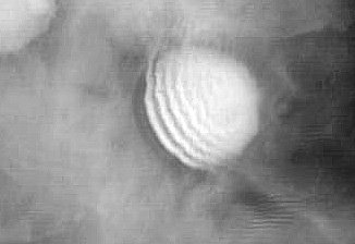
The uniform gray is thought to be the “fog”. As it passes across a crater (66°S), the topography causes a disturbance that produces ripples in the water-bearing thin atmosphere.
Future Missions to Mars
This discovery needs verification and more specific new data. Needless to say, the likelihood of abundant water has galvanized that segment of the scientific community that promotes an ultimate manned mission to Mars. Presence of extractable water not only supplies drinking needs but processes exist to break down the water into hydrogen and oxygen gases which can be made part of a fuel system to power vehicles returning to Earth. Oxygen thus released could be used for breathing in any base established on Mars for continuing manned exploration. A number of missions to continue exploration have either been approved or are being carefully planned and considered. Among these are ESA’s Mars Express and two NASA Mars Explorer Rovers (MER) both targeted to start for Mars in 2003 when Mars will be in an orbital position that brings it as close as 35 million miles from Earth..
The Mars Express was successfully sent towards Mars on June 2, 2003, with arrival in December of that year. Among its 9 instruments is MARSIS, a radar capable of penetrating many meters into the Mars surficial deposits. It will also try to place a lander, named “Beagle 2. This view is an “exploded” diagram of the main components of this spacecraft:

The two MERs are both designed to search for water. Each MER looks like this:

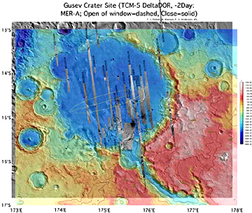
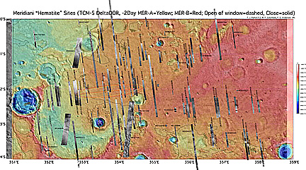
MER-1, nicknamed “Spirit” was launched towards Mars on June 10, 2003. MER-2, called “Opportunity”, was launched on July 7, 2003. Both will arrive in early winter (January) of 2004. As data are returned, we will describe the functions of key instruments, and results, at that time. For now, here is a plot of the landing sits for Express and the two MERS set on a backdrop of the Nars surface in a global projection:
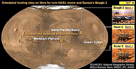
Spirit is headed for Guzev crater, which may contain frozen water inside. Opportunity will go to Meridiani Planum and land among rocks rich in hematite (iron oxide) which can be associated with water-rich conditions. Here are the landing sites:
The Japanese Space Agency sent a Mars probe, called Nozoma, in July, 1998. Because it failed to get enough “kick” to its thrust towards Mars it had to receive the needed boost by repeated orbits. It is now on its way with a scheduled arrival in December 2003, but it is experiencing operational problems and may not succeed in its mission. If it does, and the others also work right, Mars will receive four “Christmas presents” as 2004 approaches.
Proposed follow-ups “down the road” are the Mars Reconnaissance Orbiter (launch in 2005; designed to improve water inventory), at least two NASA Mars Scouts (2007 and 2011), the joint French/NASA Netlander ((2007), NASA’s Smart Lander (2009), and two NASA Smart Landers (second decade. Not all of these have received final approval. This next list includes possible candidates for the Scout program of small but well-equipped spacecraft:
Artemis: Three small landers and microrovers on the Martian surface, with two directed to the polar regions, to explore the surface and shallow subsurface for water, organic materials and climate;
Mars Environmental Observer: An orbiter to investigate the role of water, dust, ice and other materials within the Martian atmosphere to understand parts of the hydrologic cycle;
Mars Scout Radar: Orbiter mission that radar maps the surface geomorphology and very shallow subsurface – down to about 10 to 16 feet (three to five meters) deep – to detect buried water channels and other features;
Naiades: A suite of tiny landers that explore for subsurface liquid water using a novel low-frequency sounding method; and
CryoScout: Designed to use heated water jets to descend through Martian polar ice caps. Device could potentially probe to depths of tens to hundreds of meters, or yards, while measuring composition and searching for organic compounds.
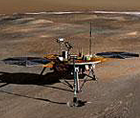
In August 2003, NASA announced the funding of a versatile lander, named Phoenix, which will concentrate on detection of organic material - in response to the continuing rancorous disputes that life should exist in the upper layers of martian materials, especially where water is proved to be abundant. The Lunar and Planetary Laboratory at the University of Arizona will manage this (Scout) program. The target date for launch is 2007 with touchdown in 2008. The landing site will be in the north polar region. With a robot arm surficial samples will be examined by TEGA (the Thermal Evolved Gas Analyzer). Other instruments will include a mass spectrometer and a wet chemical lab for soil analysis. Here is an artist’s view of Phoenix on Mars’ surface:
NASA’s home page on Solar System Missions has a section on Mars missions that describes most of the above.
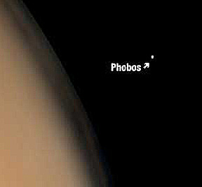
Martian Satellites

Small craters dot its surface but one large one, named Stickney, came close to disrupting it. This cratering is consistent with the likelihood of collisions with smaller objects during a period of residence in the asteroid belt. The grooves may relate to this crater.
Phobos, large as it seems in this image, is very tiny when compared to Mars as a whole. This image shows a small part of the red planet with Phobos at its actual relative size. This clearly supports the argument that the two satellites are just captured asteroids.
Deimos has fewer craters and a smoother surface:

Mars, the outermost of the terrestrial planets, remains an exciting and diverse place to visit (perhaps by humans) in the foreseeable future. NASA, and much of the scientific world, continues to promote the idea of a Mars Manned mission, sometime after the year 2010, and after more unmanned probes visit the planet. The International Space Station, now under construction, and scheduled for completion in 2002, would be a favorable launch pad for Man’s great adventure to the Red Planet.
` <>`__19-51: Assuming enough fuel to get home, besides food what essential products would you need to bring with you if you go to Mars to explore for a week or so? `ANSWER <Sect19_answers.html#19-51>`__
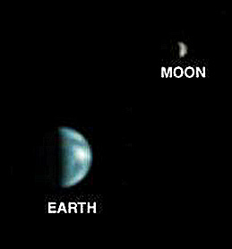
We close our visit to Mars with a remarkable image made by pointing the MGS MOC back at the Earth. In this view, our planet shows variations in color that correspond to its “big blue ball” sobriquet given by astronauts seeing Earth from the Moon.
A worthy goal for the future of space exploration is to have the astronauts themselves see this vista from the surface of Mars.