Martian Landscapes: Linear Features, Volcanoes, Impact Craters, Channels; Exotic Terrains; Mars Stratigraphy
Three prime features of the martian landscape are volcanism and volcanoes, linear structures indicating some tectonism (but not plate tectonic movements of crust), and impact craters. It appears that the bulk of the martian rock materials are volcanic, probably of low silica (basaltic) nature. The martian crust in its broad or first order state can be subdivided into old, heavily cratered terrain in the southern hemisphere and younger, less cratered terrain, with abundant volcanic features in the northern one. The martian surface displays both conventional (i.e., similar to Earth�s) and exotic terrains and erosional/depositional processes. One of great importance is sinuous channels that are much like river beds on Earth. This holds big implications: that Mars once had, and may still have, some water, probably for the latter part of its history in subsurface storage. Mars may also have had in the past enough water to develop large lakes or ocean-sized bodies. Like the Moon, Mars has large-scale erosional and depositional units which give it a general stratigraphy that allows geologic maps of its surface to be drawn.
Martian Landscapes: Linear Features, Volcanoes, Impact Craters, Channels; Exotic Terrains; Mars Stratigraphy
A reminder: As has been alluded to before in this subsection, Mars seems to consist of two dominant terrains - the northern half is mostly a volcanic plains with numerous volcanic phenomena, but is only moderately cratered; the southern part of Mars also consists of igneous (probably volcanic) rock crust but that is much more heavily cratered and has not seen major surface reworking or lava paving. Tectonic features - almost entirely faulting (probably tensional) are found over the entire planet.
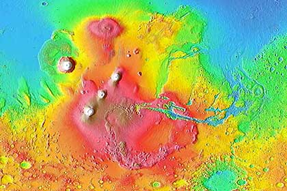
Many of the scenes depicted below occur in and east of the Tharsis region of Mars. To establish these in their physiographic context, here is a MOLA derived topographic map that includes some of the landforms we will visit:
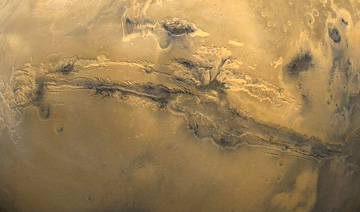
We start with the greatest trench in the ground ever discovered in the solar system. Look at this Viking color mosaic, extracted from the near hemisphere view we showed earlier, here centered on the most conspicuous feature on Mars: the Valles Marineris which extends nearly 4,000 km (2,486 mi) (close to the width of the 48 contiguous United States) and attains depths between 2 and 7 km (1.25-4.35 mi).
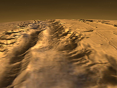
This is what you would see if flying over the Valles (canyon). The image is made by combining a Viking view with MOLA data; there is no vertical exaggeration.
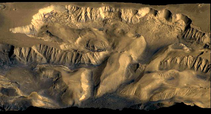
The canyon is actually a series of structural troughs, produced by faulting, radial to the Tharsis bulge to the northwest, which rises some 11 km (6.8 mi) above the surrounding plains, on which are the three dark-shield volcanoes , named on the preceding page. These volcanoes reach about 10 km (6.2 mi) above the bulge. A look inside the canyon wall, along a segment called South Candor Chasma, conveys the sense of steep slopes, perhaps furrowed by water erosion, and basal landslide deposits.
A close-up of a slide in Valles Marineris gives details of the massive debris pile-up, as material pulled away from the steep canyon wall.
Along some edges of Valles Marineris are what appear at first to be tributary valleys. But they don’t enter at levels equivalent to the floor base. They seem to criss-cross in a pattern that suggests tectonic control. One proposed explanation has them as due to subsurface water sapping.
` <>`__19-39: What general explanation can be given for the formation of Valles Marineris? `ANSWER <Sect19_answers.html#19-39>`__
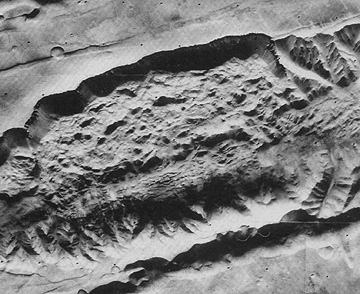
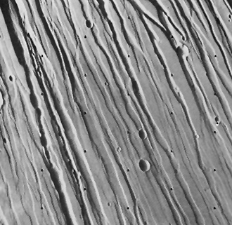
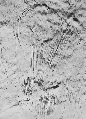
Other tensional grabens are found in various parts of Mars, especially in the newer terrains. These can occur in intersecting networks, such as below which portrays Noctis Labyrinthus in the northern Tharsis region. This tecto-morphological feature is also called fractured terrain.
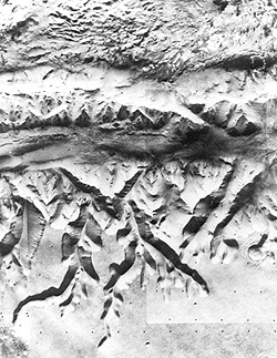
Sets of subparallel fractures cuts across the terrain on the flank of the Tharsis region (Tharsis is a huge upbulge of martian crust more than 4000 km across and 10 km higher than surrounding lowlands at its top; Olympus Mons and the Tharsis volcanoes attest to it volcanic nature). In overall pattern, the sets are radial to the Tharsis apex. Here is one such set which cuts across older craters (but several younger craters superpose on the fractures).
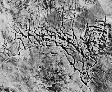
As is often true for volcanic terrains (such as the East African Rift), sets of close-spaced parallel grabens (fault-bounded downdrop blocks of crust) related to tension induced by loss of support after lava withdrawal have been found also on Mars:
At the other extreme, short fractures may appear as isolated gashes, as seen here. These may be incipient or early stage breaks in a surface undergoing only moderate tensional stress.
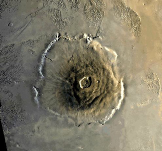
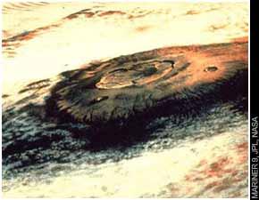
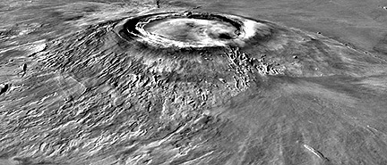
Next, we switch our review to volcanism on Mars. We show (top), from Mariner 9, and later from Viking (center), the huge structure known as Olympus Mons in the Tharsis region, which is a broad shield volcano (now dormant), many times the area and volume of the big island of Hawaii, which consists of basaltic outflows from several major vents. Olympus has a median diameter of 625 km (388 mi) and a height of 25 km (16 mi). Its elliptical central caldera, shown in a zeroed-in view (center), is 80 km (50 mi) in major axis. Olympus Mons is the largest volcanic structure known on any of the planets. A cliff 6 km (3.7 miles) high surrounds it, and stands out in the perspective view (bottom), derived by combining an image with topographic data obtained from laser altimeter data. Scientists still debate the origin of this cliff, but some of them cite it as evidence of an escarpment resulting from wave erosion by an ancient (now vanished) ocean that may have covered at least part of Mars. Note the distinctive grooved terrain (volcanic origin?) beyond the volcano’s edge.
applied to Mariner data.|
` <>`__19-40: This steep cliff around Olympus Mons is peculiar and not characteristic of terrestrial shield volcanoes. Speculate on a possible origin. `ANSWER <Sect19_answers.html#19-40>`__
Once above the fringing escarpment, the slope of Olympus Mons is gentle - 1 to 3 °. However, this incline allows lava flows to move downslope, as shown in this example from Mars Orbiter:/p>
There are three volcanoes lined up in the Tharses Montes area east of Olympus Mons; from south to north they are Arsia Mons, Pavonis Mons, and Ascraeus Mons. Each is a large shield volcano with a well developed central caldera. Typical is Arsia Mons, about 300 km (200 miles) wide at its base:

A side view made by combining a Viking image with MOLA elevation data gives this impression of Arsia Mons:
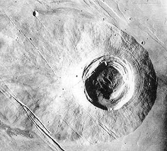
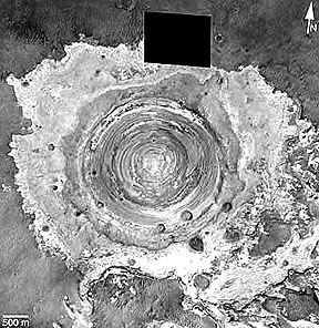
One of the best formed volcanoes in Bilbis Patera, which lies between Olympus Mons and the Tharsis group. As seen here by Viking Orbiter 1, the base of the volcano is about 100 km (62 miles) in diameter. The caldera is large compared to the total size, like some volcanoes in the Galapagos Islands off the Ecuador coast.
The largest volcanic structure on Mars is the great bulge in the northern Tharsis region known as Alba Patera, only a few kilometers high but 1600 km (1000 miles) in longest dimension. As such, it rates as the largest shield volcano in the Solar System.It is broken by a series of concentric fractures and a set of elongate, subparallel fracture grabens, as seen in this Mariner mosaic.
At Alba Patera’s top are an older summit caldera (left) and a smaller, more recent one. Note the lava flows descending its gentle slopes.
Alba Patera’s flanks show numerous overlapping flows, indicating multiple periods of lavas extruded from tube outlets both at the caldera and along the slopes. In this Viking Orbiter image, the flows are flat-topped but steep-sided; volcanic ridges appear in the lower left.
Extensive impact cratering was observed by Mariner 4, which sent back the first ever images (21 all told) taken of another planet’s surface (one seen in the top photo below) by a space probe that approached to within 9800 km (6086 miles). As imaged the next year by Mariner 6, the Sinus Sabeus region of the southern highlands (bottom) preserves typical impact craters in the ancient terrain that apparently has not been extensively resurfaced by lavas. Note that none of the larger craters in this view have central peaks.
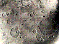
Mariner 9 and the Vikings confirmed that a large fraction of the (older) martian surface mainly in the southern hemisphere remains heavily cratered. This is evident in this sketch drawing from Mutch et al., The Geology of Mars, 1976 in which all craters larger than 15 km are positioned.
cratered uplands.|
A recent study made by a colleague of the writer (NMS), Dr. Herbert Frey of NASA Goddard - assisted by his teen age daughter Erin - has led to a map of the distribution of large surface-visible plus now buried impact structures that nevertheless show circular surface manifestations. The latter have been located using the MOLA laser altimetry data.
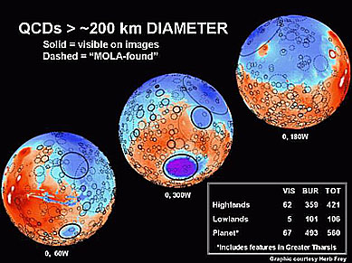
One can argue that this landscape has many similarities to the still cratered Earth in its early stages before extensive water had collected into major oceans. Likewise, buried impact structures can be discerned on the lunar surface. These have since been covered by lunar ejecta. This may mean that the martian surface is also covered by ejecta deposits that spread over older craters.
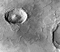
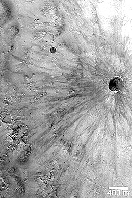
Some of the martian impact structures retain well-preserved ejecta blankets that display prominent lobes, such as seen here around the crater Yuty. The ejecta was probably fluidized by vaporization of carbon dioxide-rich ice lying just beneath the surface.
One type of impact crater is different from those on the Moon, Mercury and Venus in that the edge of the ejecta blanket has a steep scarp, evident in the Viking image below, or even a peripheral rise called a rampart. This type is called a pedestal crater.
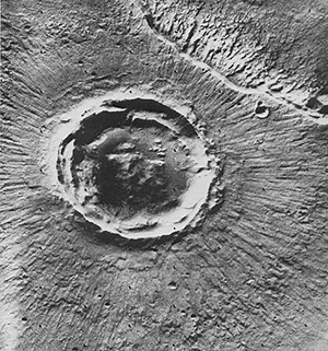
This next crater is small, young, and shows most of the same features as do terrestrial craters. Located in Terra Meridiani, this crater is 2.6 kms wide (1.6 miles; rim to rim), has at least 1 nested slump zone in its interior and a distinct exterior ejecta blanket, and has exposed what appears to be internal layering of the martian surface units. The image was made by the Mars Global Surveyor.
This central layering also appears in the 2.3 km (1.5 mile) wide Schiaparelli crater, seen below. The layering appears horizontal:

These observations of sedimentary-like crater interior floors and walls (layering is also discussed on the next page) seem rather mysterious to the writer (NMS). On Earth, craters that still retain their original rims (almost?) never show the bedrock below the final crater excavation wall. Yet this is common in martian craters with initial walls intact. Martian planetologists have suggested removal by erosion (they mean almost certainly wind erosion). The writer speculates on an alternate cause: the lower martian gravity allow nearly complete escape during crater formation of the bulk of the ejecta; the floor remains exposed because in the smaller craters slumping has not destroyed the walls.
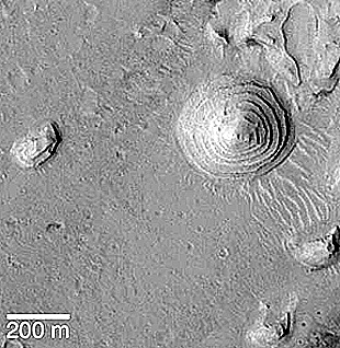
An interesting “inversion” of landforms displaying layering occurs in this small mound analogous to a circular “butte” on Earth. It shows layers that form ledges that decrease in diameter going up to the feature’s peak. The mound is in a crater floor and may be a residual remnant of layered crater fill (wind deposits; lake beds?).
Still another large impact crater, Poona, has a remarkable uniform set of rays, equispaced over the full 360° around the rim:
This small crater (below) shows a distinct pattern of dark rays. Because martian winds are continually altering the surface, both removing and covering up debris, the crater (and those above with lighter-toned rays) can be young - age estimates have ranged between a few thousand and a few million years.
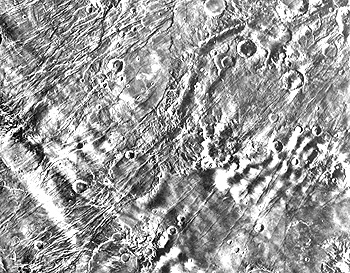
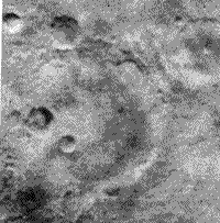
This next Viking scene, in the southern Highlands, seems to have both impact and volcanic craters. Some without ejecta beyond their rims, especially the elliptical one, are calderas. Several others have aspects more characteristic of degraded impact structures. This was an active region, with channels (either volcanic or stream) and other types of terrain.
Highlands of Mars; Viking Orbiter.|
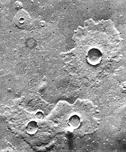
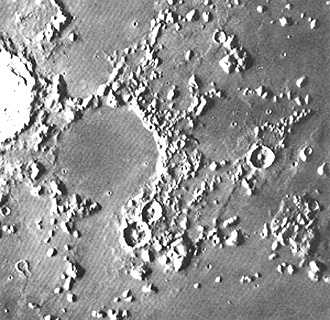
Now look at these three craters (Ulysses Patera):
Viking Orbiter.|
` <>`__19-41: What type(s) of craters are present in this Viking scene (the largest structure is about 80 km [50 miles] across at its base)? `ANSWER <Sect19_answers.html#19-41>`__
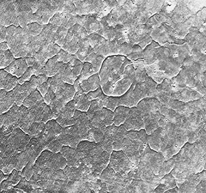
Because of several factors, some martian craters appear as faint rings rather than topographic features raised above the surface. These have been called “ghost” or “stealth” craters. They represent some combination of burial by crater ejecta, wind erosion, dust cover, and ice cover. Here is an example of this last type:

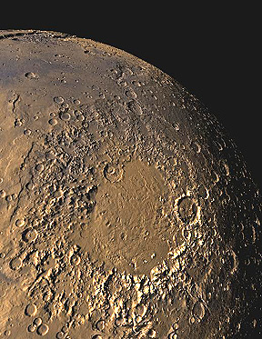
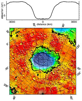
As with the Moon, Mars has a few craters so large that they can be called impact basins. The second largest (600 km; 390 miles diameter) is the Argyre Basin, seen in this Viking view:
The landscape just beyond its rim looks remarkably like parts of southern Utah, except for the pinkish-orange rather than blue sky:
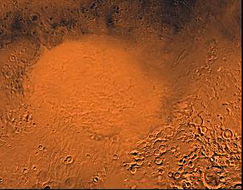
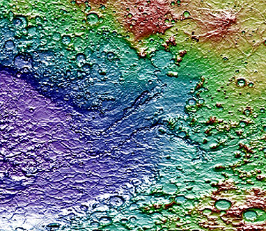
The largest impact basin on Mars, and seemingly the largest in the Solar System, is the Hellas Basin in the southern Highlands. Its diameter is about 2100 km (1300 miles), its depth is almost 9 km (6 miles) and its rim exceeds 1.5 km (1 mile). As seen by Viking in a wide-angle oblique view, the huge size of Hellas dwarfs the rim and interior elevation differences. In this view the Basin appears to have no significant landforms within it.
To emphasize the size of this structure: If all material excavated from it were to be spread evenly over the 48 continental United States, a layer of debris some 3.5 km (2 miles) thick would accrue. Below is an enlargement of the map covering this structure.
The floor of Hellas actually shows diverse landforms, some of which appear volcanic in origin (this assumes the basin filled with melt soon after the impact event).
Among features believed volcanic in nature are linear ridges similar to the wrinkle ridges found in lunar maria. Here is a topographic map made from MGS MOLA measurements that includes (in the purple) these ridges and shows the diversity of other landforms.
Mars investigators have speculated that during the early eons of martian time, when the atmosphere was possibly more abundant (thicker, with greater surface pressure), water released by impacts and other processes could be distributed as rainfall. Some think that shallow lakes filled Hellas, Argyre and other large craters for a time.
So, once again we see a planetary body with a great variety of landforms, many caused or affected by impact processes. Some of these are unusual (exotic) including those which may reveal water erosion.
Channels and Exotic Terrains
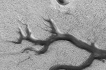
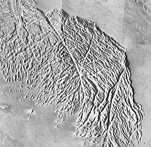
Some of the big surprises were infrequent but distinctive sinuous channels, whose morphology is much more similar to river channels that lava channels. One interpretation holds this morphology as evidence of sufficient water in the past, in lakes, groundwater or possibly oceans, to have initiated some sort of hydrologic cycle involving rain storms and runoff. Most water has since evaporated into space, although small quantities may remain frozen as underground ice. Nevertheless, significant water activity has recurred as evidenced by the types of dendritic channeling shown in these Viking Orbiter image mosaics:
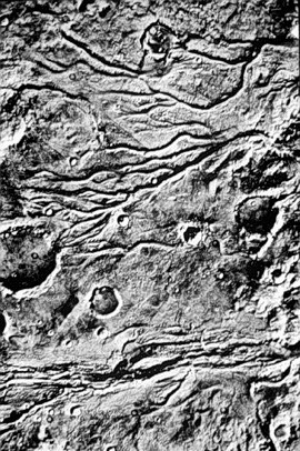
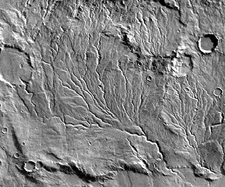
The region depicted in the top image covers the Juvenae Chasma and Vedra Vallis. These are runoff channels, a type confined to the ancient landscapes. Stream flow is the favored origin, largely by comparing them with terrestrial counterparts, but multiple lava flows are a possibility. Some channels seem to originate at craters, which could imply that subterranean sources released either water or lava, following impact offloading. The drainage pattern in the bottom image resembles terrestrial patterns found in soft sediments or wind deposits.
` <>`__19-42: What is the argument that the type of channels shown above is not volcanic sinuous rilles or collapsed lava tubes? `ANSWER <Sect19_answers.html#19-42>`__
The resemblance to fluvial channels on Earth is further evident in the next (MOC) image. Located within the large Newton craters, the dark (windblown sand-filled?), flat-bottomed channels look like some headwater types found on Earth:
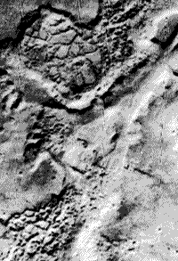
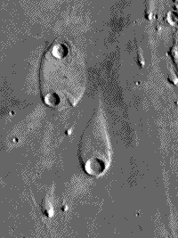
A distinctive type of drainage called outflow channelling are typically broad and deep, creating canyon-like depressions. This type of landform may have been associated with catastrophic scouring during abrupt flooding. A similar example on Earth is the Channeled Scablands of central Washington State in the U.S. that developed in just a few weeks from rapid emptying of a huge dammed lake after a natural breakup. Outflow features commonly occur next to chaotic terrain (top image, below; note the large outflow channel in the middle), in which surface units break into jumbled blocks and huge slabs, left behind after subsurface waters escape, leading to loss of support (a process called sapping). We consider a teardrop-shaped landform in Elysium Planitia (bottom image) a prime example of shaping by streamlining (analogous to aerodynamic sculpturing), in which water flowing from bottom to top has eroded plains material around the rim of a large crater and has terraced and perhaps redeposited debris towards the pointed end.
|
|
` <>`__19-43: Present an argument as to why the teardrop landform was caused by water rather than wind. `ANSWER <Sect19_answers.html#19-43>`__
A recent paper has presented an alternative to water as the prime liquid medium responsible for the above channels and streamlike patterns. In this view, CO2 (carbon dioxide) is proposed to exist in liquid form and in flowing upon expulsion at the surface brings about the erosional features described as fluvial. A variant of this suggests that liquid water at the times in the past when Mars was warmer may have contained a significant amount of dissolved carbon dioxide (“soda water”) that increased its ability to erode.
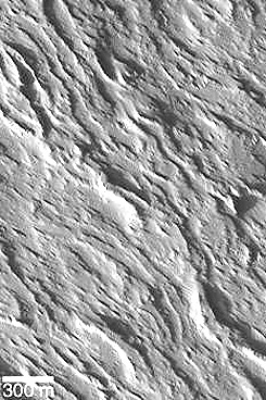
The martian surface is amazingly varied, with landforms of diverse genesis, some probably related to water action, as you have just seen, and others to tectonic forces, volcanism, and wind, being given descriptive names. Here are four examples:
The mishmash of intersecting linear features, called grooved terrain , in this case may be a complex surface of eroded ash deposits or possibly joint enlargement of a now buried remnant of a volcanic lava unit.

The next image portrays etched terrain which consists of shallow depressions likely developed by wind scouring and deflation of easily erodable unconsolidated surface materials.

Other landform types given distinctive names (see the map near the top of page 19-11) include: furrowed terrain, knobby terrain, channeled terrain, and layered terrain. Examples of several of these are shown elsewhere in the Mars subsection.
` <>`__19-44: From the above list, decide which name best fits the terrain shown in the image below; ignore the large craters. `ANSWER <Sect19_answers.html#19-44>`__
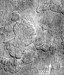
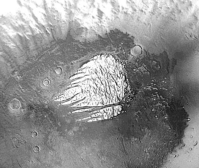
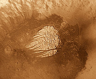
Some of these exotic terrains can also be calle enigmatic. Lets illustrate this claim by looking at a series of images that center on what was called “White Rock” after its discovery in Mariner 9 images. The feature is a light-toned landmass, strongly embayed, that rises above the floor of the crater named Pollack (seen here in a MGS MOC image) in the southern highlands at a low latitude:
In a Viking black and white image, this feature, which is approximate 12 x 12 km in dimension, indeed has a higher albedo than the crater floor (very dark) and thus stands out as an off-white feature. But comparing it to a Viking color image indicates 1) it has the same reddish surface coating that most of Mars has, and 2) it “whiteness” is largely due to contrast with the floor; its gray tone level is similar to surface materials beyond Pollack’s rim.
One of the early interpretations considered it to be ice preserved as a patch in the crater. One investigator proposed this feature to have been ice extruded from depth, much like salt forms in domes and may reach the surface. This was discounted by radiometric measurements that indicated too high a temperature and later measurements that ruled out H2O and CO2. Interest was renewed in White Rock from MOC images taken onboard the Mars Global Surveyor. Consider this next pair that zero in on the several prongs of the feature:
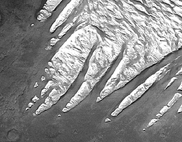
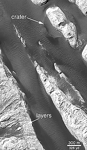
Mars scientists now interpret this feature to be dissected lake beds, if Pollack was once filled with water. Others propose volcanic ash deposits that collected inside the crater and are being systematically removed (by wind?); no nearby volcanic vent is evident that would account for this. Still other explanations have been proposed. No consensus explanation has been reached at this time. The evidence in the last image of layering is not convincing to this writer (NMS). Of interest are the series of thin, arcuate equi-spaced lines in the dark areas between the ridges. These seem to be controlled by the ridges. My interpretation is that they are regular dune-like markings that may result from martian winds that are directionally channeled by the ridges - but this is speculation.
There is still much to do to properly categorize and explain the surface features on Mars.
An excellent review article, “The Unearthly Landscapes of Mars” by Arden Albee, appearing in the June 2003 issue of Scientific American offers further insights into the surface features of the Red Planet.
Stratigraphic Units Maps of Mars
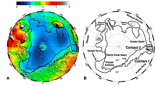
As on the Earth, layering - which gives rise to stratification - can be caused by several processes. On Mars, layering from dust deposits laid down in the present and by inference in the past and layering from impact ejecta (probably the dominant process) build-up are established mechanisms that account for perhaps the majority of stratified sequences. As we have seen several times on this page, there is now strong evidence for the action of water from streams and other outpouring mechanisms operating in the martian past. Some students of the martian surface argue that at one or more time(s) in the past, there were lakes and perhaps even oceans on Mars that existed when the martian climate was warmer than today - gone now because most of the water has either dispersed into outer space or become frozen in the upper reaches of deposits near the surface. James Head III and his colleagues at Brown University have interpreted evidence, including cliffs and terraces that may indicate shoreline erosion, of at least two stages of oceanic concentrations of water in the northern lowlands. Here is their map:
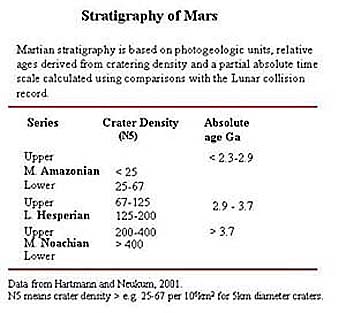
The occurrence of marine sedimentary layers on Mars is still much debated, with no direct proof. But, like the Earth and its Moon, layered materials found on the martian surface follow the Law of Superposition, which defines the relative ages of overlapping deposits. And, like the Moon and some other planetary bodies, the relative densities of craters have been counted over its surface, which has led to a broad stratigraphic division of the principal geologic units that are recognized on Mars:
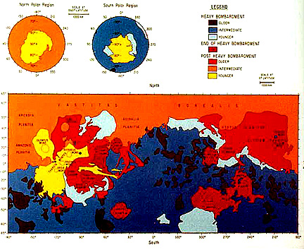
The global surface of Mars can be displayed in terms of these relative crater densities, as shown:
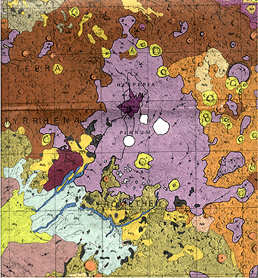
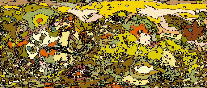
A general “stratigraphic units” map of Mars , produced by standard photogeologic methodology, is shown below with the key to these units beneath it:


The U.S. Geological Survey has produced quadrangle maps of most of Mars by now, as illustrated by this one which shows the Hesperia Planum and Tyrrhenia Terra regions of Mars.
The full global map of Mars at scales of 1:15000000 and 1:25000000 has been published by the USGS. It was not found by the writer after surfing the Net, perhaps because of its size (would be many megabytes if all the lettering must be legible). Here is a variant of most of that map, shown without a legend or annotation:
It should by now be evident that Mars has a diverse and intriging history, with a wide variety of surface features. But the story has gotten even more interesting since the
Primary Author: Nicholas M. Short, Sr. email: nmshort@nationi.net