Remote Sensing Tutorial Page 19-9
Contents
Magellan has confirmed that Venus, like the other planets that have not developed a surviving ocean nor have had crust destroyed by plate tectonics, is dominated by volcanism, has had some tectonic adjustments, and still has numerous large impacts suggesting limited modification of a possibly still original outer crust. This is well-documented by the variety of Magellan images shown on this page.
Magellan’s greatest revelations were a wide variety of volcanic features. It is not an exaggeration to refer to Venus as the “Volcanic Planet”. Most of the planetary surface has been judged by geoscientists to by less than a half billion years old. Some volcanism even appears to be recent and the possibility that there is even now some activity cannot be dismissed. Impact craters, while present, are uncommon, with perhaps 200 large enough to be resolved by Magellan’s radar; this is consistent with the presumption that the venusian surface is relatively youthful, as the crater flux by then would have greatly diminished.
The following sequence of Magellan images, each briefly described, is representative of surface classes and distinctive structural features that typify the venusian landscape.
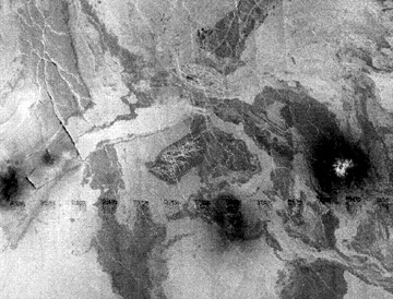
The first is characteristic of the plains regions. Here at Lakshmi Planum are several light and dark surfaces that are interpreted to be equivalent to the basalt flow types known as pahoehoe (smooth lavas; somewhat specular surfaces) and known as pahoehoe (smooth lavas; somewhat specular surfaces) and aa (chunky lavas, better backscatterers) - counterparts to common Hawaiian lavas.
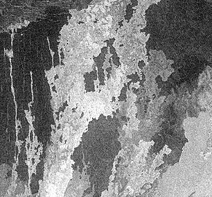
Lava flows emanate from the Sils Mons volcanic source.
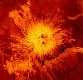
Flows can sometimes be traced to shield volcanoes (with central calderas), as in this colorized rendition of Sapus Mons (1.5 km high) in the Alta Regio region.
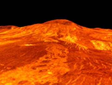
Perspective color views of this type of volcanic structure, made by applying altimetry data to the radar image, show it to be much like a shield volcano, with a broad base and often a central depression. This rendition of Sif Mons, about 2 km (1.2 miles) high and covering an area of nearly 300 km (200 miles) in diameter, illustrates this:
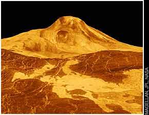
One of the highest mountains on Venus is Maats Mons which reaches to 8 km (5 miles) above the mean venusian elevation:
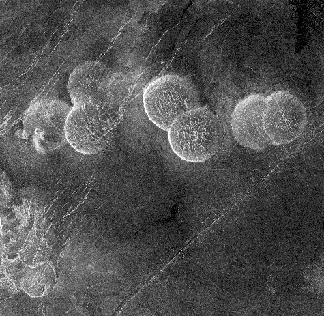
Cinder cones and stratocones (Vesuvius-like) are rare on Venus. Here is one example of a swarm of cones (each about 2 km wide) on the plains that are larger than cinder cones but not typical of stratocones.
` <>`__19-30: If large volcanic edifices like, say, Mount Rainier or Fujiyama were to occur on Venus, what would that imply? `ANSWER <Sect19_answers.html#19-30>`__
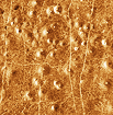
Domical hills, as much as 25 km (15.5 mi) wide and up to 750 m (2,460 ft) high, dot plains in the Alpha Regio. We believe these pancake-shaped features result from upwelling at tubular vents of lavas that spread uniformly in all directions.
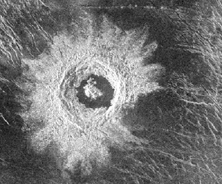
The next vertical view of the venusian surface exposes two unusual structures - given quaint names to set them apart - that seemingly develop from fracture patterns in the lava plains.
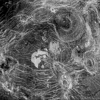
Russian scientists dubbed the broad web-like arrangement of linear features “Arachnoids,” because of its resemblance to a spider’s web. Smaller elliptical to circular structures, known as Corona(s) (or coronae, Latin for crown) may be similar to ring dikes known on Earth. Other coronas, like the one displayed next, may be collapsed domes.
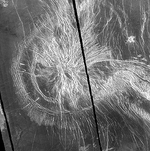
` <>`__19-31: Explain the fracture pattern in the above corona. `ANSWER <Sect19_answers.html#19-31>`__

Collapse calderas are also found on Venus. The one shown below, Sacajawea Pater, is elongate, has steep inner walls, but no notable ejecta-like deposits beyond its rim.
Peculiar terrain at Ovda Regio in the Aphrodite Terra is characteristic of long low mountain ridges, running NE-SW and spaced about 20 km (12 miles) apart; a dark band is a low valley.
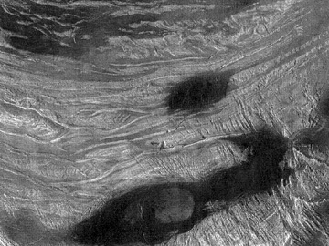
Other parallel ridges are closer-spaced and may be volcanic wrinkles or squeeze-ups through a series of fractures:
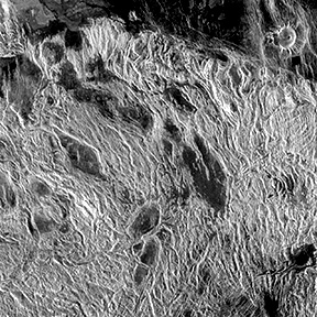
Prominent NW-SE bright surface features, possibly some kind of parallel fracturing, cut the ridges. A better look at systematic fractures in a plains surface appears below:

These NW-SE gashes are criss-crossed by numerous small ladder-rung like fractures, which may be analogs to regularly spaced megajoints found in certain terrestrial settings.
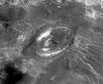
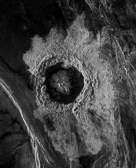
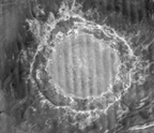
The next scene is Golubkna crater, 30 km (18.5 miles) wide, which is nearly identical to impact structures found on the Earth, Moon, Mercury and Mars. It is distinguishable from calderas by the prominent, strongly reflecting ejecta deposits running up to the rim.
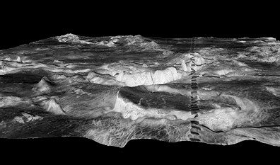
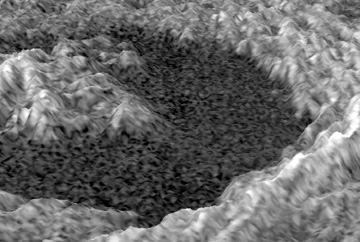
Visible in some impact craters are central peaks, a nest of terraces, and a wide apron of ejecta which stands out as bright because of the rough scattering surfaces. These are emphasized in this computer-generated perspective view of one venusian crater:
Crater Dickinson below, formed in a lava plains, is perhaps partially filled by lava (much like the Moon’s Tycho) although a partly exposed central peak was not submerged:
` <>`__19-32: Look at the image below which pictures the largest (280 km; 174 miles) crater, Mead, found on Venus. Would you identify it as volcanic or impact in origin, and give reasons why? `ANSWER <Sect19_answers.html#19-32>`__
Because of the great diversity of surface features revealed by Magellan, Venus will remain a high priority target for space exploration well into the 21st Century.