The Martian Atmosphere; Ice at the Poles
The general physiography (landform types) of Mars is examined. Some types do not have close counterparts on Earth. But, although the atmosphere of Mars is thin, high velocity winds stir up loose surficial materials producing dust storms and aeolian deposits such as dunes. The martian polar icecaps have both conventional and unusual features including layering and collapse structures.
The Martian Atmosphere; Ice at the Poles
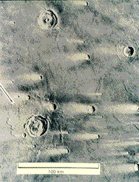
Before looking at some more representative images, we set up a geologic framework for Mars: the planet, fourth from the Sun, is a little more than half Earth’s diameter at 6,793 km (4,218 mi), about double that of the Moon, and has about 1/10th its mass. Mars’ lower density implies a small metallic core, now solid, as borne out by the lack of a distinct magnetic field. It rotates once every 24 hours and 37 minutes (Earth time). Its surface temperatures range from -140° to 20° C. From Earth-based telescopic observations, we suspected Mars had oxidized, iron-rich materials at its surface, was subject to dust storms, and had ice caps at both poles that alternately expanded and contracted over a martian year (687 Earth days). The storms implied at least a thin gaseous envelope (out to about 125 km). Spectroscopic measurements indicated CO2 and maybe nitrogen. The Mariner/Viking missions greatly modified our concepts of the martian landscapes. Consider the generalized landform maps of the two martian equatorial hemispheres, drawn on a Lambert equal-area projection from mission results, as shown here:
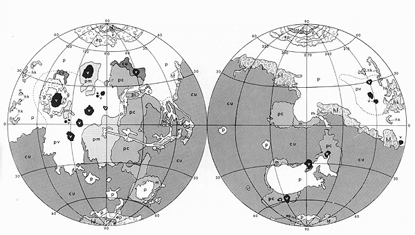
From T.A. Mutch et al., The Geology of Mars, © 1976. Reproduced by permission of the Princeton University Press, New Jersey.
The lower polar hemisphere contains cratered terrain (cu), considered to be billions of years old (and the likely source of the 3.5 b.y. old meteorite containing organics, found in Antarctica), where the bulk of the larger impact structures survive. Much of the upper hemisphere has plains units (p), many thought to be volcanic flows (pv) (mainly basalts?) and volcanic constructs (v) (such as shield volcanoes), some of whose ages could be less than one-half billion years. Other subdivisions include cratered plains (pc) and moderately cratered plains (pm). Unusual or specialized units consist of channel deposits (c), grooved terrain (g), knobby hummocky terrain (hk), fretted hummocky terrain (hf), chaotic hummocky terrain (hc), and mountainous terrain (m). Units confined to the polar regions are: permanent ice (pi), layered deposits (id) (thought to be layers of windblown dust interspersed with ice), and etched plains (ep). As with Venus, structural signs of plate tectonics are absent.
Many features in these categories are also landmarks and physiographic provinces. In the left hemisphere, the three volcanoes in a row (Ascraeus Mons [top], Pavonis Mons [center], and Arsia Mons [bottom]) are in the Tharsis Montes group and the two large ones above and to the left are Olympus Mons (largest volcano in the solar system) and Alba Patera (a caldera-capped volcano). The long, curvilinear feature (c) near the equator in the left hemisphere is the great Valles Marineris, many times longer and much deeper than the Grand Canyon, with associated chasmas or tributary canyons. In the right hemisphere, the large area (p) in the southern half is Hellas Planitia, site of the biggest impact basin on Mars, cut into ancient terrain and backfilled with lava.
19-36: The Tharsis region shield volcanoes are huge by Earth standards. What single volcanic structure on Earth comes closest to these in size and morphology? `ANSWER <Sect19_answers.html#19-36>`__
The missions confirmed the martian atmosphere consists of 95.3% CO2, with the remainder being mostly N2 (2.7%), argon (1.6%) and minor O2, CO, and enough water, if condensed, to fill an average swimming pool. Atmospheric pressure averages 7 millibars or about 0.7% of Earth’s, but windstorms within this thin envelope can reach speeds greater than 200 km/hr (124 mph). Clouds of water-ice are fairly common in season, especially near the poles. This Viking Orbiter image shows clouds above the martian limb and perhaps clouds over the land.
Orbiter image; also perhaps over the land.|
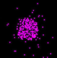
The presence of small amounts of oxygen has been confirmed by x-ray emissions monitored by the Chandra X-ray telescope. O2 is excited by x-rays accompanying the solar wind. The amounts seem to vary, as seen in this Chandra image:
Both Mariner 10 and the Viking Orbiters gathered many images showing various aspects of atmospheric circulation, such as this view of spiraling clouds above the martian North Polar region; note also the bright patches of ice.
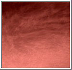
The martian atmosphere is generally hazy, resulting from suspended dust and possibly some water condensate. Instead of the blue sky of Earth, one peering up from the Mars surface would see its sky as grayish-yellow to reddish, depending on the time of the martian day. Although Viking Landers gave some indication of these colors, the next image, from Mars Pathfinder’s camera looking well up into the sky, is a good rendition of color near sunrise; the clouds are of the cirrus type as known on Earth.
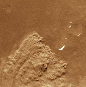
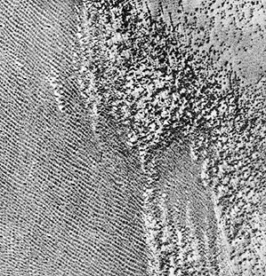
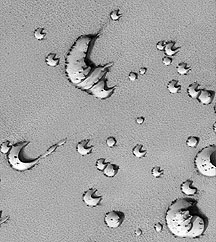
Mars is now known to not be DEAD as a planet. As we shall see, there may be active water transfer, buildup of ice caps, and possibly volcanic eruptions. Certainly, as evident from the previous imagery, its thin atmosphere is remarkably active, with fast-moving winds picking up and redepositing surficial particles in dunes and other aeolian features. Here is a “candid camera” image of what on Earth are called dust devils - tornado-like wind swirls that pick up surface fines to create a tubular or thin funnel-shaped cloud that sweeps across the surface. This Mars Orbiter Camera (MOC; see page 19-13) image shows a thin dark trace along a crater wall made when the dust-devil (actually moving; at the left end) removed material from the wall:
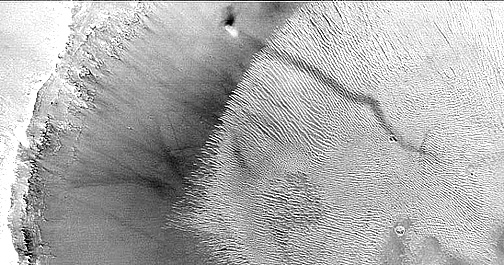
Thin dark markings, often found in swarms, on parts of the martian surface, have now been identified as trails caused by numerous dust devils scouring the loose surficial material. Here is a striking example:
As further proof that Mars is meteorologically active, a dust storm was caught in the act of happening:
When enough of these regional dust storms form, they coalesce and sometimes cover the entire planet for many (earth) months.
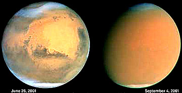
More than half the planet was engulfed in a widespread dust storm that began in July of 2001 and started to diminish in September. Compare these “before” and “after” Hubble images of minimal and maximal dust coverage; note how the surface features in the left image are masked by the pervasive, near global dispersal of dust into the atmosphere as seen in the right image.
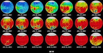
Using the Thermal Emission Spectrograph on Hubble, a sequence of images taken between June and August, 2001 shows the variations in density of dust in the martian atmosphere.
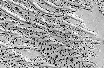
The martian dust and sand is frequently spread out as wind streaks.
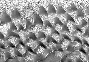
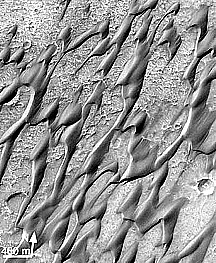
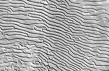
Despite the very low density of today’s martian atmosphere, its high speed winds can cause erosive sculpturing, and can deposit uplifted dust and sand into vast dune fields. The Viking Orbiter image below contains transverse (elongated, or parallel) and barchan (crescent) dunes laid down in a plains setting.
A second image shows parallel dunes on the left and barchan dunes on the right.
` <>`__19-37: Why is it rather surprising that dunes with types similar to those on Earth are so widespread on Mars (hint: consider the atmosphere)? `ANSWER <Sect19_answers.html#19-37>`__
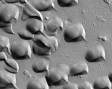
More striking close-up views of dunes have been imaged by the Mars Global Surveyor (MGS; MOC) (see page 19-13). Crescent dunes very similar to those found on Earth also develop on Mars, as seen in this MGS ) image:
A variant of this type leads to dunes that approach crude circles in shape.
A MOC close up view of barchan dunes appears next:
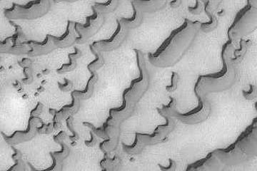
The martian dunes come in a wide variety of forms. This MOC image shows dunes with a broad, gentle slope and steep, ragged foreface:
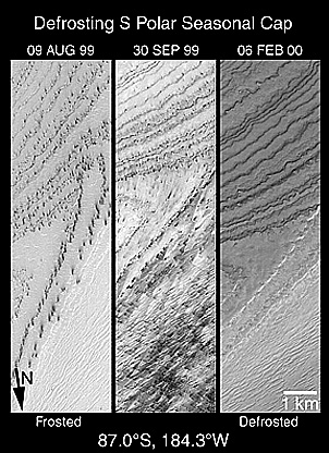
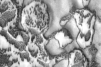
Similar dunes, with odd shapes, are evident in this next image in the north polar region. The dark dunes (which may have a high percentage of basalt-like dust and grains) are now exposed after seasonal frost has evaporated from them (in the martian summer there) but stand out because permafrost and/or ice is much lighter (more reflective).
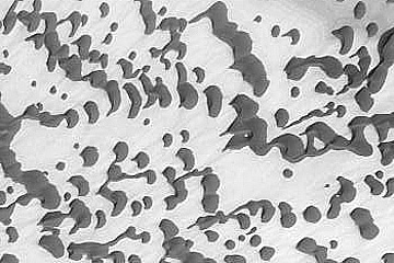
This image shows individual dunes so close-packed that there is no interdune space. Such a density is rare on Earth. The field has developed near the South Pole.
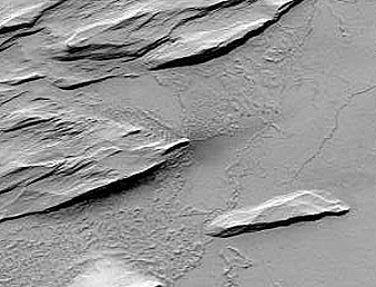
Another feature with a terrestrial counterpart is the yardang (see page 17-5), formed by wind scooping out soft materials and leaving ridges in between. Here is a martian version:
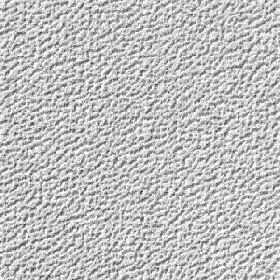
The bottom line: At present almost all of Mars is covered with a thin to thick set of dust layers. This often obscures smaller surface features. Here is a MOC view of a smooth dust cover draped over surfaces at Pavonis Mons.
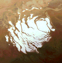
Turning now to the frozen materials that persist or build up/dissipate in the North and South pole regions. The dominant surface constituent of the polar caps is CO2, but major amounts of water seem to be locked within the caps themselves as subsurface concentrations (see page 19-13). The next views show the South Polar ice cap (top) and North Polar ice cap (bottom) (which may contain more water) near their maximum growth stage, during a martian winter. This winter recurs about every 685 Earth days at each pole. In about half that time the polar ice at one pole shrinks as summer warming evaporates the frozen gases, and possibly subliming water underneath and the opposing pole experiences ice condensation and growth:
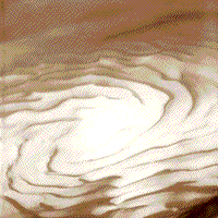
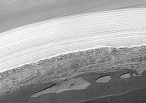
The layering associated with this icecap, probably representing seasonal deposits of dust (see below), is even more obvious in this regional oblique view of the top of the Northern Hemisphere:
|Layers in the Northern Hemisphere within the north polar icecap. |
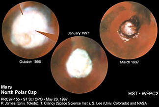
Considerable change in size of both ice caps occur over the Winter to Summer transition. This three-panel set of images made using the Hubble Space Telescope (HST) illustrates variation of areal coverage at the North Pole over a 6 earth month period from late 1996 through early 1997:
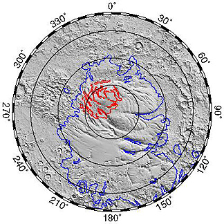
Observations now over several decades have strengthened the fact that the ice is more widespread in the northern polar region and tends to persist longer but shrinks more during the warming season. The higher elevations in the southern hemisphere may account for this difference, being cooler at those heights. Here is a map of the maximum and minimum extents of the north polar cap during the growth/shrinkage phases:
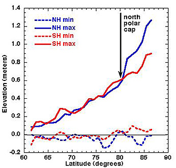
This change in polar cap thickness over time, determined by elevation differences in meters, has been measured at both pole regions by the laser altimeter (MOLA) on the MGS, with these results:
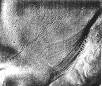
The surface of an ice cap shows distinctive changes during sublimation and shrinkage as shown in this MOC image of a part of the south polar ice:
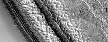
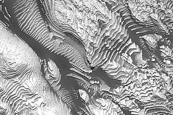
Dust layers in the polar caps have been spotted in pictures from earlier missions that imaged this region on Mars. Details (at 25 m resolution) have been acquired by the Mars Orbiter high resolution camera. Here are layers in the South Polar ice cap:
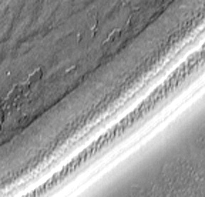
Closer looks at the sides of the polar caps revealed prominent alternating bands of light (the ice) and dark (the dust) materials, as seen here in these two views of the south polar cap:
And here is a view of banding in the ice at the martian North Pole:
This next image of banding may be illusory.
` <>`__19-38: Try to devise an explanation for these layers in this last image. `ANSWER <Sect19_answers.html#19-38>`__
The Mars Global Surveyor has been looking more closely at both poles. In the fringes around the polar ice caps, dark spots appear and disappear over the course of a martian year. In this image, these spots occur midst a dune field. It is not yet known whether, and how much, water ice and/or carbon dioxide frost coatings are involved in the on-going evaporation that produces the spotting, which may be dune material showing through.
This process of frost evaporation is more advanced in this next image, in which removal of the white coating is exposing dark dune sands beneath.
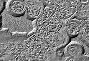
Interesting structures and patterns are developed on the CO2 ice. Quaint descriptive names are picked by the investigators to characterize surfaces. In the two images below, the top has reminded them of “swiss cheese” while the bottom looks like a “kitchen sponge.
Much of the ice at each pole may exist in the form of grains, much like sand. As the polar ice undergoes changes during the evaporation/deposition cycle that affects the poles, strong winds are capable of moving these grains into barchan-like dunes, as shown in this image of the surface of the North Pole Ice Cap:
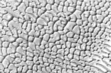
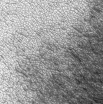
On Earth, one feature that abounds on ice sheets is sets of intersecting cracks that produce what is termed “polygonal” ice. This has been observed also on Mars in the polar regions where is is one type of patterned ground. It usually shows up after the warming of the polar region sublimates the coating of carbon ice. Here is an example from the South Polar ice cap.
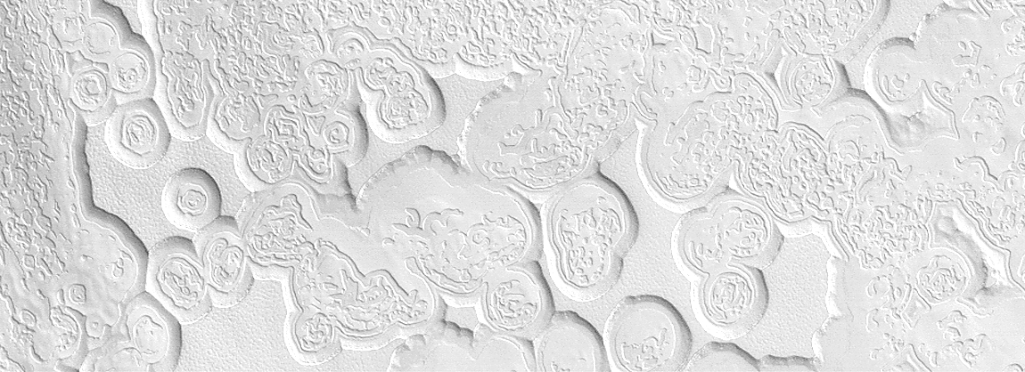
A curious feature seen by the Mars Global Surveyor near the South Pole is evident in this next image. Several domelike (nearly circular) structures occur midst what is similar to fretted terrain (exemplified on page 19-13). These domes have steep narrow outer slopes and a wide craterlike interior. Although suggestive of volcanic structures, their origin is unclear.
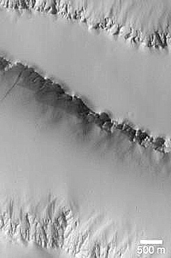
Finally, among other polar landform curiosities is this set of straight, equi-widthed troughs noted at in the North Polar cap:
Lest one builds an impression that ice is found only at high latitudes on Mars, let us state in closing this page (but treated in detail on page 19-13) that evidence is now strong that water ice is present beneath the martian surface (as permafrost analogous to that found in Alaska and Siberia) over much of the planet. But, being dust and rock fragment covered, it is not visible in images of those vast regions.
Primary Author: Nicholas M. Short, Sr. email: nmshort@nationi.net