Mars, The Red Planet
Contents
Next to Earth, no other planet has fascinated people as much as Mars, the Red Planet, one and a half times the distance from the Sun as we. Although little was actually known about Mars before the Space Age, the notion that astronomers such as Percival Lowell saw markings on Mars that reminded them of canals led to a ficticious hope that this meant (human) life may be present. Mars figured in several classic science fiction stories, such as H.G. Wells “War of the Worlds”. Then, in 1962 a space probe sent back the first pictures of the martian surface and the natural wonders of this planet soon outweighed those of imaginative writers. The next four pages will summarize what we are still learning. We start with several good images of the planet in different half sphere positions and then recount the major trips to Mars by various spacecraft.
Mars, The Red Planet
We switch now to the region beyond Earth, as we explore the Mysterious Planet Mars, recently upgraded in interest because of the discovery of possible evidence of single-celled, organic matter (life?) in a meteorite (found in the Antarctic), believed to have been ejected into deep space from an impact on ancient Martian crust. After the Earth and its Moon, Mars has become the most intensely studied solar system body because of its similarity to Earth itself (but as a planet that has lost most of its water) and therefore is a candidate for once or still active biological material. Spacecraft today are orbiting it, surface rovers are planned for it, and NASA - as well as the whole world community - is hoping for enough evidence of its special features to warrant a long-term program culminating in Man’s setting foot on its surface. Another reason for the attention given to Mars is that it has many features explainable by extrapolation of geologic studies of Earth (and some features without terrestrial counterparts – and these are easily “seeable” because of total absence of oceanic and vegetation cover.
Here are four Web sites to consult if you want a quick overview of Mars or images to download: (1), (2), (3), (4)
Mars’s mean diameter (6780 km [4875 miles]) is 0.53 that of Earth; its volume is about 1/8th that of Earth. A martian day is almost the same as a terrestrial day; Mars takes 1.86 Earth years (685 days) to complete its orbit around the Sun. Its orbit is distinctly elliptical (1.38 A.U. perihelion to 1.67 A.U. aphelion; average distance of 1.52 A.U.). Its rotational axis is tilted 25°, similar to Earth, which causes Mars to have summer and winter seasons. Mars has a mean density of 3.93 g/cm3 compared with Earth at 5.52 g/cm3; it likely has a much small inner core that may be iron-poor.
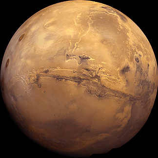
Look below at a beautiful, full-face image of a Martian hemisphere, which should make it obvious why Mars is also known as the Red Planet. This mosaic was constructed from reprocessed Viking images. Two conspicuous features, described later, are the huge gash across the face, known as Valles Marineris, and the three great volcanoes in the Tharsis group, on the left.
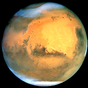
Compare this with a single (not mosaicked) image of a face of Mars, taken through the Hubble Space Telescope.
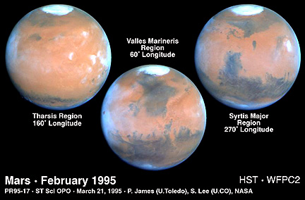
Then, look at these three hemispherical views of Mars taken by the electronic camera system on the Hubble Space Telescope (HST) through filters that allow close approximations to true color. The blues along the limbs are somewhat artificial.
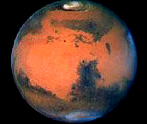
A more recent Hubble image has been processed to fully contrast the color differences; thus:
` <>`__19-33: From these four full face views, what would you deduce about martian rocks? `ANSWER <Sect19_answers.html#19-33>`__
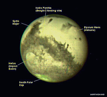
In late August of 2003, Mars became a “hot item” in TV and Newspaper accounts. Mars’ orbit is such that most of the time it lies beyond 160 million km (100 million miles) from Earth. But there are rare times when the two planets positions in their orbits place them much closer together. On August 27, 2003 Mars and Earth were at the closest distance (55,890,000 km or 34,500,000 miles) apart. This had not happened until about 60000 years ago but will happen in about 600 years into the third Millenium. Thousands of amateur telescopes, 100s of Observatory telescopes, and the Hubble Space Telescope all trained on the Red Planet (which was just less than Venus as the brightest object in the Sky) and many photographs were taken. The two below were made by the Hubble Space Telescope in orbit and the UKIRT (United Kingdom InfraRed Telescope. ground-based in Hawaii):
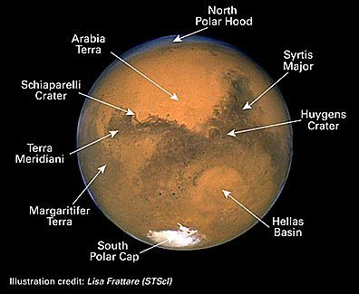
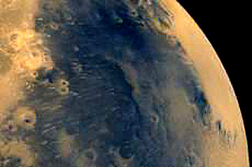
The overall surface state of Mars, judging from these full planet face views, is that it consists of three major color states: 1) the predominant reddish colored surface, which is now known to be regions in which the rocks, soils and dust are strongly oxidized into phases consisting of hematite, possibly maghemite (the γ polymorph of Fe2O3 and similar minerals [including the group of hydrated iron oxides going under the name of “limonite”, if water at and beneath the surface could “weather” the hematite]); 2) the dark bluish to blackish surface, presumably bedrock with less iron discoloration, and 3) the whitish areas around the poles, identified as a mix of water and carbon dioxide (the outer coating). The second color phase implies that the surface is bedrock with insufficient iron oxide dust cover to significantly alter the color depicted; this suggests much less onsite alteration of the basalt and the transient nature of dust cover as martian winds remove much of previously deposited red dust (but some may be cyclically deposited during strong dust storms [see next page]). An an example of the second color phase, look at the Syrtis Major physiographic region. It probably is volcanic crust, likely basalt. It size, however, varies from time to time because winds carry red dust back and forth over its boundaries.
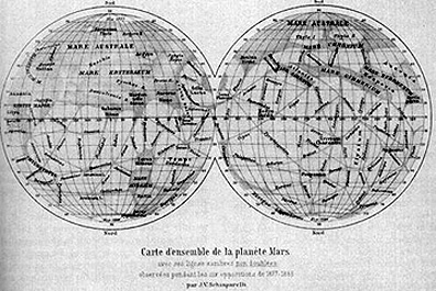
Mars was the first extraterrestrial planet mapped in some detail, solely from telescope observations. Thus, in 1881, Giovanni Schiaparelli published the map below, in which many of the features he named are still known as such in today’s nomenclature. Although these names are illegible in the figure below, we reproduce this map for its historical importance:
Sir Percival Lowell, using a telescope he built on a hill in Flagstaff, Arizona, extended this mapping. His 1909 map shows are large number of nearly straight lines, which Schiaparelli had called “canali”, that he “thought” he could see. This led to the widespread belief into the second half of the 20th Century that there might be canals on Mars used by its “inhabitants” to transport water. Thus was born the legend of Martians (e.g. H.G. Wells “War of the Worlds” brought these creatures by spaceship to Earth, only to succumb to the adverse biological conditions on our planet). These canals, of course, disappeared when the good views shown above were obtained.
It is difficult to reproduce on a Net site a modern map that shows all of Mars with its many features identified. We will try with this simplifiedversion:
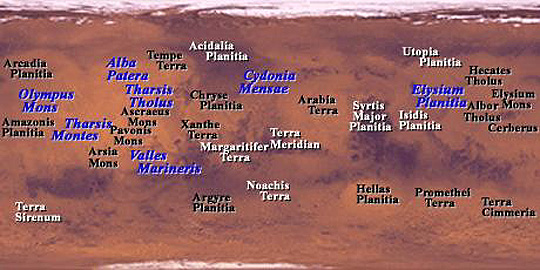
We recognize the difficulty of familiarizing yourself with so many feature names and their locations. However, from this list find the following: Olympus Mons; Arsial Mons; Pavonis Mons; Valles Marineris; Alba Terra; Arabia Terra; Noachis Terra; Argyre Planitia; Chryse Planitia; Hellas Planitia; Elysium Planitia; Terra Cimmeria.
The above map is hard to read. To assist you in finding some of the locations that will be called out in this subsection dealing with Mars, we have added a hidden page accessed by clicking on Here; this page contains three more maps enlarged enough to display readable names of major features.
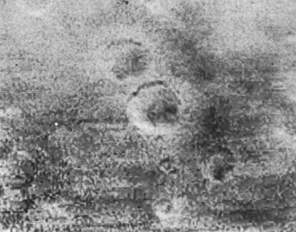
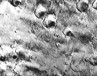
We now know a great deal about Mars from flybys, orbiting surveyors, and landings. The first flyby, by Mariner 4, on July 14, 1965, produced 22 images covering roughly 1% of the planet. Here is one of those TV views and below it is almost the same area covered by the TV aboard Mariner 9 (see below) six years later - a good measure of technological progress:
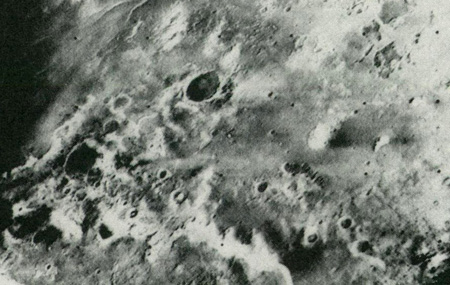
Mariners 6 and 7 passed Mars on July 31 and August 5, 1969, together obtaining 199 images that extended coverage to about 10% of the total surface. A typical Mariner 6 image shows frost-covered parts of the south polar region, with dark craters, furrows, and pits.
A quantum leap in coverage followed the first successful orbiting of another planet, when Mariner 9 arrived on November 13, 1971. Returning more than 7,300 panchromatic images, a wide-angle TV camera, capable of 1-3 km (0.6-1.9 mi) resolution, mapped almost the entire surface, while a narrow-angle TV camera imaged selected areas at 100 m (328 ft) resolution. Mariner 9 also carried an IR radiometer, an IR interferometer spectrometer, and a UV spectrometer. The imaged surface qualifies Mars as one of the most diverse and spectacular planetary bodies in the solar system. Lacking vegetation and water cover, the easily seen geologic features were often grandiose in scale and sometimes unique. As with most extraterrestrial objects, their interpretation by astrogeologists started by comparing or contrasting features with those known on Earth. Martian features often required innovative explanations.
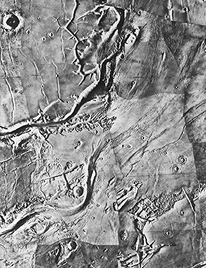
A typical Mariner 9 view, as a mosaic, shows fractures, erosion (stream?) channels, and craters.
The Russians launched Mars 2 and 3 probes to that planet in 1971, but acquired only limited data, mainly on the magnetic field. In 1973, the former Soviets sent three more spacecraft to the Red Planet. In March of 1974, Mars 4 failed to orbit the planet, but Mars 5 did, long enough to return data, including images during 10 of its 20 orbits. Mars 6 successfully descended through the thin Mrtian atmosphere but failed during the last second before touchdown.
The culmination of U.S. exploration to Mars began on August 20, 1975, and September 9, 1975, with the launches of Vikings 1 and 2 respectively. Their Orbiter components began orbiting the planet in late June and early August of 1976, coinciding roughly with America’s Bicentennial Celebration. Each carried two identical vidicon (TV) cameras, capable of color imaging (as composites of black and white images taken through color filters) and acquiring stereo scenes at 100 m (328 ft) resolution. They also bore a thermal-mapping, infrared spectrometer and a second IR spectrometer designed to detect atmospheric water.
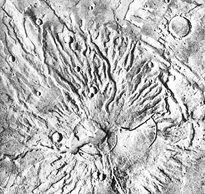
As an example of a Viking image, consider this Viking 1 view of Tyrrhena Patera, a volcano built up from both flows and abundant ash, located near the Hellas Basin in the southern hemisphere.
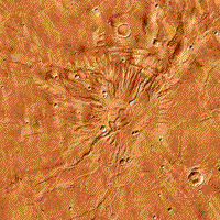
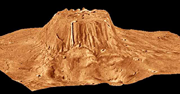
The two Viking images below show color versions of the Volcano Tyrrhena. The first image does not give a sense of relief but when we confound topographic information with this image, a perspective view, marked by strong vertical exaggeration, gives a sense of its height:
` <>`__19-34: Critique the above two views of Tyrrhena, specifically in regards to misconceptions they might give about martian topography. `ANSWER <Sect19_answers.html#19-34>`__
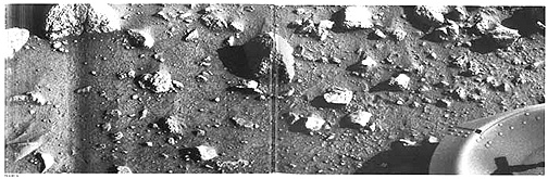
Both Vikings also transported separable landing vehicles that descended by parachute throughout the atmosphere. Viking 1 Lander touched down on July 20, 1976, and Viking 2 Lander on September 3. As with the Moon, a chief concern during the touchdowns was the nature of the surface which could be a depression (e.g., a crater wall) or covered by scattered boulders and other debris such as seen here:
So far, all landings have avoided these pitfalls. The first ever image (black and white) of the martian surface from the surface is this:
Both TVs also successfully transmitted surface views in color, of the immediate ground, up to the visible horizon.
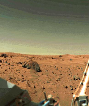
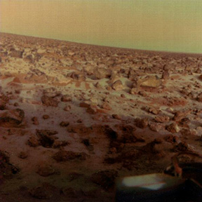
The two Viking Landers were exceptional ground-truth devices. These panoramas from them reveal a red iron-coated surface, consisting of rocks (the largest > 2 m [6.6 ft]) mixed with sand and dust, some piled into incipient dunes. In other views, some rocks look like vesicular basalt. Note the yellow-brown tones in the lower, dusty layers of the sky’s rarified gas envelope (mainly carbon dioxide). This stationary observatory was also equipped with magnets, a seismometer, an x-ray fluorescence spectrometer (that receives samples from a movable scoop), a miniature meteorological station, and three experiments seeking signs of metabolic action (mainly, as gases released or absorbed) by biogenic matter (none found).
` <>`__19-35: Using the left (or upper) of the Viking surface pictures, comment on the conditions above the martian surface. `ANSWER <Sect19_answers.html#19-35>`__
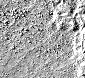
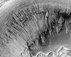
After the Vikings, the resumption of martian exploration was vested in th Mars Observer but this spacecraft failed enroute to Mars in 1993. The next visit was by the Mars Global Surveyor, launche in 1996, which orbits the planet taking pictures up to 3 meters in resolution.Three of its prime instruments are the MOC (Mars Orbiting Camera), the MOLA (Mars Orbiter Laser Altimeter), and TES (Thermal Emission Spectrometer). This spacecraft is described on page 19-13 but as a preview sample here is an image that shows at high resolution the interior wall of a small impact crater within the very large crater Newton; the series of channel strips running down the side has been interpreted as evidence for subsurface water emerging at some depth along the wall and eroding these rills (see page 19-13 for details).
The Pathfinder mission, run by JPL, landed a Rover on the surface in 1997 which conducted a series of physical and chemical experiments. Then, in October 2001, the Mars Odyssey mission reached the planet and is continuing to gather data with THEMIS, its thermal emission spectrometer, and GRS, a Gamma-Ray Spectrometer, and other instruments. In 2003, several more U.S. and International spacecraft are being sent to Mars. If successful, these will aslo be described on page 19-13.