Development trend
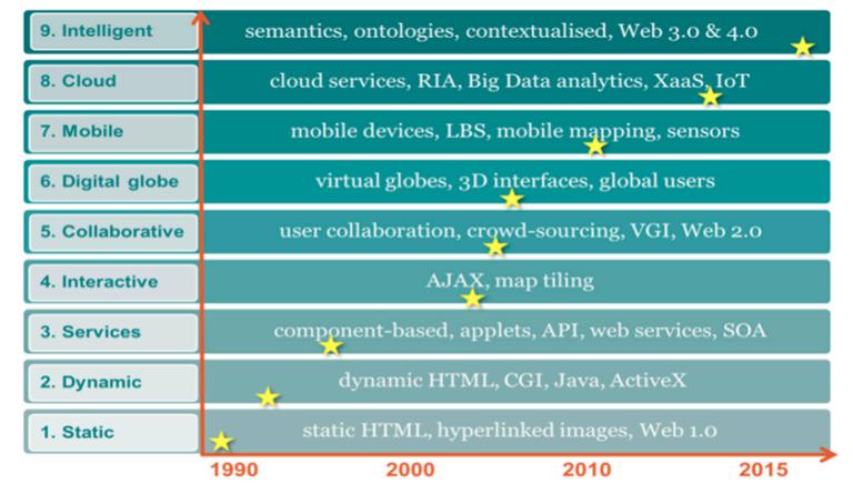
In the past few decades, the development of network map has experienced some important stages, and each stage has a significant impact on the use and further development of network map. These developments involve technology and users, and the technology under development provides a shared platform (static and cloud era); Improve response time to data requests (dynamic, service and interactive era); Provide richer interfaces for data access (to affect data accessibility); Based on earth, mobile, positioning and intelligence, support data, function and service generation (interactive, digital earth, LBS, intelligence). By analyzing the development and progress of each stage, we can collect some trends, generate potential directions, and determine the future of Web GIS.
Data is transferred from the desktop environment to the cloud. In the early days of network mapping, geospatial data and maps were generated by professionals (for example, geographic information system digitization, surveying, photogrammetry, and remote sensing), and the amount of captured data was relatively small, limited by low data, computer network bandwidth and infrastructure. In the era of cloud computing, more and more data is captured and stored somewhere in the cloud, and more and more devices online through the IoT begin to contribute more data to the network, including location-based data.The trend of data transfer from the desktop environment to the cloud, and the amount of data captured through mobile, sensor, and social media communication platforms continues to increase. In these data, a large part are geospatial images and features. In 2014, Google Maps had more than 1 billion users every month, accounting for 41% of global Internet users.
The breadth and complexity of network geospatial data functions have been extensively developed in the era of network mapping. Starting from a simple static map, as an online image, it has developed into a Web GIS system with all-round GIS functions. With the development of the interactive and collaborative web mapping era, users can not only retrieve, but also use asynchronous client/server technology to capture, edit, store, and analyze geospatial data.The era of network map services provides map servers with not only map image services, but also geospatial data and processing services. This makes GIS functions available online, as is the case with MapQuest.
The development of Digital Earth has introduced map tile technology to highly interactive 2D and 3D geographic browsers. The development of cloud-based technology has provided the infrastructure for online hosting of data and functions, and has brought about the rapid development of web mapping and Web GIS. By implementing the architecture of web database and geoprocessing services in the cloud, more GIS functions can be integrated into a real Web GIS online platform, making it easier for users around the world to access.
Emerging online maps and GIS environments are beginning to provide more support for increasing user sharing, collaboration, and team-based content provision, including real-time sharing environments that synchronize collaborators in different locations for simultaneous map sharing and geoprocessing.
More and more data, information and knowledge are captured and derived, which requires strengthening of management, functions, analysis and modeling. What does it mean for the direction and future of web maps and geospatial applications? The amount of data and information on the Internet continues to surge. Its sources include aerial and satellite imagery, crowdsourced data, online databases, sensors, and data sources from the Internet of Things. Data will be so important in the next few years that "organizations that use data unwisely will not survive." Web GIS will continue to be an important part of data science, because location (space/time) is the basic key to events, and visualization will remain one of the most powerful tools for interpreting and linking data, information, knowledge.
Comment list ( 0 )

