Remote sensing systems can struggle to spot high waters, especially in stormy weather or at night. Synthetic aperture radar offers a shot in the dark.
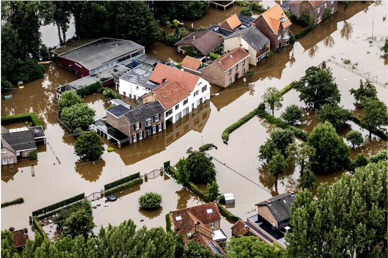
Flooding has long been the cause of human suffering—it destroys crops, livestock, infrastructure, and human lives. Climate change is increasing flooding risk, since extreme weather events and sea levels are on the rise. According to professional services firm Marsh McLennan, which specializes in risk assessment, since 1980 there have been around 4,600 floods worldwide, which together have cost more than $1 trillion in damages, or around 40 percent of the world’s total natural disaster losses. Severe floods are public health hazards, like 2020’s monsoon flooding in India, which killed 1,922 people—the year’s most fatal natural disaster, unless you count Covid. Worldwide, floods killed more than 6,000 people that year, according to the Global Natural Disaster Assessment Report.
Scientists, rescue agencies, governments, and insurance companies would all like to keep track of developing floods and predict the risk to a given area, to direct financial and physical assistance to the right places, to direct people to dry places, and to assess where building, planting, and living don’t make sense. Having reliable real-time data would be helpful, but traditional satellite pictures often fail, because clouds are, obviously, often present over the terrain during a flood. So, the images either aren’t possible—or are simply pictures of clouds.
SAR is the right sort of tool for tracking floods, says Umbra’s chief operating officer, Todd Master, not just because clouds and darkness have no bearing but because you also “get these very distinctive turns between water and not-water” and can calculate how high that water is above the ground compared where it was during the satellite’s previous passes. SAR’s returns can also tell the difference between freshwater, saltwater, and gray water. That’s useful when, say, you need to know whether seawater is intruding inland or whether an oil or sewage leak will be floating downstream.
For example, in 2017, intense floods inundated the town of Impfondo, in the Democratic Republic of the Congo, but its remoteness made sending aid and determining people’s needs difficult. Working with the Congolese government and humanitarian groups, Cloud to Street’s platform combined with SAR has since shortened flood detection times from weeks to days and provided information about where to safely relocate refugees.
Initially, Cloud to Street’s customers were governments, their disaster arms, and organizations like the World Bank, helping them figure out who needed to be relocated and where and giving them evidence they could use to lobby for additional relief funds. Today, Cloud to Street also works on more corporate pursuits, helping insurance companies tap out their risk and payout calculations.
Sources:
WIRED
https://www.wired.com/story/these-satellites-see-through-the-clouds-to-track-flooding/ .
Provided by the IKCEST Disaster Risk Reduction Knowledge Service System
Comment list ( 0 )

