University of Alaska Fairbanks researchers have devised a way to remotely detect large landslides within minutes of occurrence and to quickly determine whether they are close to open water and present a tsunami hazard. They write in a new paper that their method of determining a landslide’s location, volume and potential impact is rapid enough to support the National Oceanic and Atmospheric Administration’s goal of issuing a tsunami warning within 5 minutes of a landslide.
“The warming climate is causing glaciers to retreat, leaving behind valleys whose mountainsides and hillsides have lost their support,” said research seismologist Ezgi Karasözen of the UAF Geophysical Institute. “This is important, especially in regions like southern coastal Alaska, because huge masses of land can and do spill into water and cause tsunamis.”
Karasözen and Michael West, director of the Alaska Earthquake Center at the Geophysical Institute, detailed their method in a paper published Feb. 9 in the journal The Seismic Record. West also serves as Alaska state seismologist.
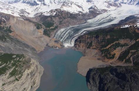
Their paper calls attention to the danger by pointing to a 2015 landslide that sent 100 million cubic yards of rock into Alaska’s Taan Fjord, located off Icy Bay, 65 miles northwest of Yakutat. The slide created a tsunami that stripped vegetation as high as 620 feet above waterline.
A landslide’s initial onset generally registers as short-period waves; it isn’t until the slide accelerates that the identifiable long-period waves materialize. Landslides produce disproportionately more long-period energy compared with other sources. Most earthquake ruptures last only seconds, while landslides routinely last a minute or more.
Coastal fjords present a significant challenge for landslide detection because glaciers can create hundreds of prominent seismic events daily, the researchers write.
Karasözen and West created an algorithm to continually scan seismic data from multiple seismic stations to look for a landslide wave signature. Finding a match, their system will estimate the slide’s location and volume. In areas with good seismic station coverage, location can be estimated to within a few miles.
The goal is to have the system alert tsunami and seismology agency personnel, but more work remains before that can occur. To create the algorithm, the two researchers analyzed data of the three recent Barry Glacier landslides and six additional landslides — five of them in Southeast Alaska and one on the west side of lower Cook Inlet, across from the Kenai Peninsula.
Other efforts have been tried over recent decades. Several researchers have shown that landslide seismograms can be used to estimate location and volume, but those efforts usually were unique to a region, required considerable fine-tuning and were not designed for real-time purposes.
Determining landslide location from distant seismic stations doesn’t allow for real-time assessment, due to the time it would take for the seismic waves to reach those stations.
West said the research augments ongoing monitoring and alert efforts. “The potential for real-time monitoring of large landslides is one important component of the interagency effort underway to address Alaska’s landslide challenge,” he said.
Source:
UNIVERSITY OF ALASKA FAIRBANKS
Provided by the IKCEST Disaster Risk Reduction Knowledge Service System
Comment list ( 0 )

