This study proposed a multi-class damage detection (MCDD) model based on a supervised machine learning classification approach to quantitatively assess the surface damage of the 2023 Turkey-Syria earthquake. The algorithm synergizes multiple satellite remote sensing data and products including Sentinel-1, ALOS-2 PALSAR-2, Sentinel-2 images to derive three critical indices, i.e., damage proxy (DP), amplitude dispersion index (ADI), and the differential normalized differential built-up index (NDBI) (post-seismic minus pre-seismic), together with peak ground acceleration (PGA). The MCDD model effectively sorts the different damage levels and is much more effective than approaches with one single individual index.
Turkey-Syria region lies on the junction of three tectonic plates – the African, Anatolian, and Arabian plates. Turkey-Syria area encompasses the Alpine-Himalayan seismic belt, which is one of the most tectonically active regions on our planet. The buried NE-SW-trending East Anatolian Fault (EAF) is characterized by a left-lateral strike-slip transform fault, which spreads over 580 km along the Arabian Plate moving northeastwards and the Anatolian Plate moving southwestwards. Geographically, Turkey is a critical transcontinental country at the boundary of Western Asia and Southeastern Europe, bordering the Black Sea to the north, Syria, and Iraq to the southeast, and the Mediterranean Sea to the southwest.
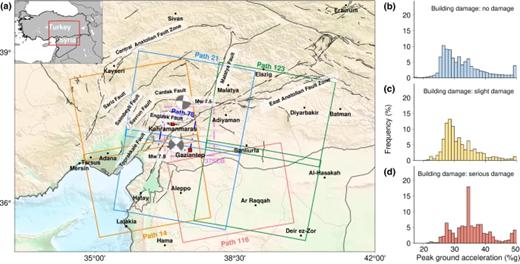
A catastrophic Mw7.8 earthquake hit southeast Turkey and northwest Syria on February 6th, 2023, leading to more than 44 k deaths and 160 k building collapses. The interpretation of earthquake-triggered building damage is usually subjective, labor intensive, and limited by accessibility to the sites and the availability of instant, high-resolution images. This study proposes a multi-class damage detection (MCDD) model enlightened by artificial intelligence to synergize four variables, i.e., amplitude dispersion index (ADI) and damage proxy (DP) map derived from Synthetic Aperture Radar (SAR) images, the change of the normalized difference built-up index (NDBI) derived from optical remote sensing images, as well as peak ground acceleration (PGA). This approach allows us to characterize damage on a large, tectonic scale and a small, individual-building scale. The integration of multiple variables in classifying damage levels into no damage, slight damage, and serious damage (including partial or complete collapses) excels the traditional practice of solely use of DP by 11.25% in performance. This approach can quantitatively and automatically sort out different building damage levels from publicly available satellite observations, which helps prioritize the rescue mission in response to emergent disasters.
Sources:
Natural hazards
https://www.nature.com/articles/s44304-024-00003-0#Sec8 .
Provided by the IKCEST Disaster Risk Reduction Knowledge Service System
Comment list ( 0 )

