Login   |      Register
English    中文


Bangladesh Dhaka flood risk assessment on 30 meters


Bangladesh Dhaka flood risk assessment on 30 meters

Label :

Date: 2023-11-28

View counts: 328

Browse document: Browse document

Download Dataset: Log in

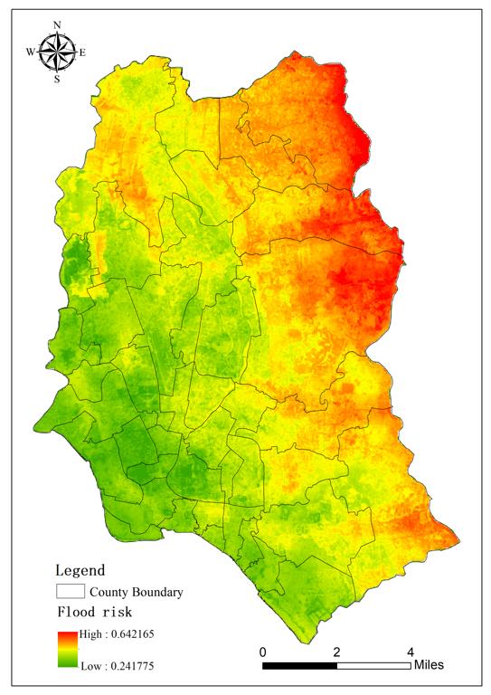
This 10-meter fine-scale flood hazard, sensitivity, vulnerability, and risk assessment dataset for Dhaka, Bangladesh, uses river network density, elevation, slope, and vegetation cover to assess the sensitivity of the environment that harbors the hazard; and mean annual rainfall, number of consecutive days of rainfall, and historical peak rainfall as indicators of hazard for assessing hazard-causing factors; The vulnerability of hazard-bearing agents is evaluated using data on population density, road network density, land use type, and lighting; a thorough risk assessment is conducted by combining hazard, sensitivity, and vulnerability and creating a dataset product of hazard, sensitivity, vulnerability, and risk. With a spatial resolution of 30 meters, the dataset's spatial area is the city of Dhaka, Bangladesh.

Title alternate
Bangladesh Dhaka flood risk assessment on 30 meters
Parent identifier
Basic Disaster information
Language
English
Type
raster
Creator
Yang Fei
Contributor
Data classification standard of Disaster Risk Reduction Knowledge Service
Date creation
2023.11.03
Contributor agency
Institute of Geographic Sciences and Natural Resources Research, Chinese Academy of Sciences
Contributor email
yangfei@lreis.ac.cn
Data citation
Bangladesh Dhaka flood risk assessment on 30 meters dataset. Disaster Risk Reduction Knowledge Service of International Knowledge Centre for Engineering Sciences and Technology (IKCEST) under the Auspices of UNESCO,2021.05.28. …………
Data record num
2.04 MB
Responsible address
A11 Datun Road, Chaoyang District, Beijing
Responsible email
ikcest-drr@lreis.ac.cn
Responsible postcode
100101
Responsible telephone
010-64889048-8006

    Sign in for comments!

Comment list ( 0 )