Remote Sensing Tutorial Foreword
Contents
DEDICATION
of the
REMOTE SENSING TUTORIAL
To The *Memory* of
SPACE SHUTTLE COLUMBIA (STS 107) ASTRONAUTS
WHO HAVE GIVEN THEIR LIVES TO UPHOLD A NASA TRADITION:
SPACE - FOR THE BENEFIT OF ALL MANKIND
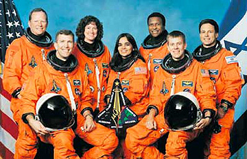
The Crew From Left to Right:
Seated: RICK HUSBAND, KALPURA CHAWLA, WILLIAM McCOOL
Standing: DAVID BROWN, LAUREL CLARK, MICHAEL ANDERSON, AND ILAN RAMON
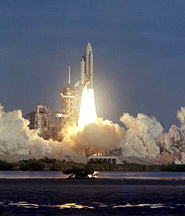
Columbia was the first ever Space Shuttle to go into space, on April 12, 1981, as seen in liftoff here:
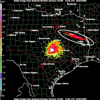
Columbia’s last moments in space were at 9:00 AM EST as it began to break up over central Texas:

Remote Sensing played a role in monitoring this tragic event. Below is a weather radar image of the stretched out debris and smoke from the exploded Shuttle Columbia extending from north-central Texas to western Louisiana. The strong signals from the Dallas-Fort Worth area are “ground clutter” caused by radar reflections from buildings.
One can surmise that this thought would be the Columbia crew’s earnest wish if they could communicate to us from the hereafter:
LIKE THE PHOENIX OF ANCIENT LORE, LET MANNED SPACEFLIGHT RISE AGAIN AND ASTRONAUTS CONTINUE TO EXPLORE THE SKIES OF EARTH AND THE PLANETS.
PLEASE PROCEED TO THE FOREWORD BELOW
FOREWORD
NASA’s Earth Sciences program is primarily focused on providing high quality data products to its science community. NASA also recognizes the need to increase its involvement with the general public, including areas of information and education. Many different Earth-sensing satellites, with diverse sensors mounted on sophisticated platforms, are in Earth orbit or soon to be launched. These sensors are designed to cover a wide range of the electromagnetic spectrum and are generating enormous amounts of data that must be processed, stored, and made available to the user community.
This rich source of unique, repetitive, global coverage produces valuable data and information for applications as diverse as forest fire monitoring and grassland inventory in Mongolia, early typhoon warning over the vast Pacific Ocean, flood assessment in coastal zones around the Bay of Bengal, and crop health and growth within the plains of the United States. Additionally, the commercial realm is also developing and launching various high resolution satellites and marketing these data worldwide.
The Applied Information Sciences Branch at NASA’s Goddard Space Flight Center is heavily involved in technology outreach and transfer. As part of this activity, we recognized the need for a highly intuitive, easily accessible remote sensing tutorial that hopefully will serve as a primer for the new user as well as a teaching tool for the educational community. We wanted this tutorial to provide a detailed understanding of the utility of the data in light of the fundamental principles of electromagnetic energy, especially as they relate to sensor design and function.
Enter Dr. Nicholas Short, a former NASA Goddard employee and author/editor of four NASA-sponsored books (Mission to Earth: Landsat Views the World; The Landsat Tutorial Workbook; The HCMM Anthology; and Geomorphology from Space) germane to the subject of remote sensing. We asked Nick if he would be willing to put his significant experience and talents to work to present an updated and expanded version of his past efforts. The result is this CD-ROM (also on the Internet) entitled “The Remote Sensing Tutorial”. As the CD/Net versions progressed, we were joined by the Air Force Academy as a co-sponsor in supporting the later phases of the project. We trust you will find it informative and useful, and when you are done, please pass it on to a colleague or friend. Remember, think globally and act locally.