The early Web GIS experienced the stages of static map publishing, static Web GIS and interactive Web GIS.In recent years, the following three factors have formed the basis of the early development of web GIS: First, under the promotion of the release of free satellite images and the occurrence of major disaster events, the use of surveying and mapping and geographic information system technology to manage and respond to such incidents has significantly improved the public's awareness of geographic information systems; The second is the emergence of new Internet technologies, namely AJAX and map tile technologies, both of which focus on reducing the response time of network maps. The third is location services based on wireless networks, enabling users to access geographic information systems and mapping technologies on the move.
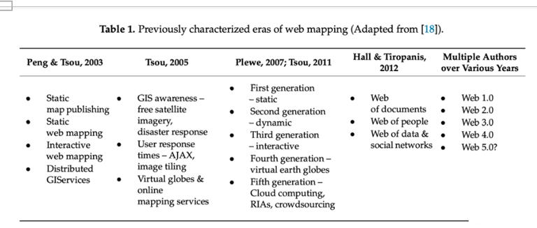
According to the type of technology supporting the map, the five-generation network map was determined. The first generation map is a static map, such as the map created by Xerox's parc map server. They are static maps embedded in HTML files, which can be accessed by simple clicks through hyperlinks.The hyperlink selects the map for the user to view. The next generation includes dynamic HTML maps created dynamically using Java and ActiveX. At that time, the map user interface began to appear similar to a GIS interface. However, the function is limited to map browsing and simple query. The third generation of web GIS is driven by the development of asynchronous JavaScript and XML (AJAX) technology, which shortens the response time and paves the way for direct interaction between users and the map. This provides a way to open service application programming interfaces (Api), which can be accessed and combined with user-contributed data during the generation of mashups.Finally, the fourth generation focuses on virtual earth spheres, such as NASA Worldwind, Google Earth and Microsoft Bing, which provide users with a more realistic and immersive three-dimensional earth experience. The emergence of these first public network services covering digital images around the world opened up the geospatial world drawn on the public map of the world via the Internet. Its ability to generate maps goes far beyond the scope of a small group of web developers and cartography experts.The fifth generation based on cloud computing, rich Internet applications (RIA) and crowdsourcing, users can access cloud computing resources and services instead of focusing on obtaining sufficient hardware resources and downloading desktop software, which now includes, for example , Amazon cloud storage and web services, Microsoft Azure cloud and ESRIArcGIS online.
The network first appeared as a file network, then transformed into a social network for people, and now it has developed into a network for data and social interaction. The latter transition of the network focuses on stronger connections involving people and data, that is, the interaction between people around information and knowledge, which includes collaborative mapping, location-based and mobile activities, dynamic processes, and geographic environments, interactions and so on.
With the continuous development of Web technology, including the development in the field of geospatial, people are still guessing what content may be included in future web development. People are paying more and more attention to human-computer interaction with automated and semi-automatic decision-making.
Comment list ( 0 )

