Detailed field surveys of 12 cities, towns and disaster areas (intensity Ⅷ and above), and the high-resolution remote sensing data of other 128 cities and towns (some cities as shown in Part Ⅳ)on spot perform have been made the image pre-processing and enhancement processing. Based on these,the artificial visual image interpretation is the main method, combined with seismic damage change detection method, automatic classification method,comprehensive analysis of multi-source remote sensing data. The earthquake-induced building damage is applied and extracted.
On the basis of scientific investigations and extractions of seismic damage on spot, seismic damage index statistics are adopted in the block as a statistical unit. In term of this,the field surveys identify the destruction of building as level 6. When implementing the formula(Fig.1)to calculate the seismic damage index, dij is assigned as: destroyed (collapsed) 1.0, destroyed(not collapsed)0.9, severely damaged 0.7, moderately damaged 0.4, slightly damaged 0.2, not damaged 0. Based on the average of seismic damage index, it was converted to equivalent seismic damage index of brick structure according to the prevailing types of building structure. And then synthetic seismic damage index of the block referring to the formula(Tab.1)is obtained.
| Seismic Intensity | Range of Seismic Damage Index | Average of Seismic Damage Index |
|---|---|---|
| Ⅵ | 0.0-0.1 | 0.05 |
| Ⅶ | 0.1-0.3 | 0.2 |
| Ⅷ | 0.3-0.5 | 0.4 |
| Ⅸ | 0.5-0.7 | 0.6 |
| Ⅹ | 0.7-0.9 | 0.8 |
| Ⅺ | 0.9-1.0 | 0.95 |
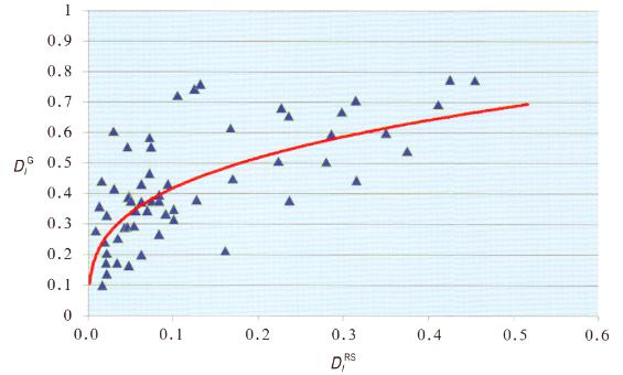
The seismic damage identified by remote sensing is classified into three levels, of which dij are assigned to collapsed 1.0, partly collapsed 0.5, not collapsed 0 respectively. With reference to the formula(Fig.1)and the formula(Tab.1), seismic damage index is computed to plot the diagram of detailed field surveys of 12 cities and towns in the block as a unit. The results indicate that remote sensing seismic damage index is less than ground synthetic seismic damage index. In this case,remote sensing reflects indirection and incompleteness of seismic damage.
The information is provided by Disaster Risk Reduction Knowledge Service
Comment list ( 0 )

