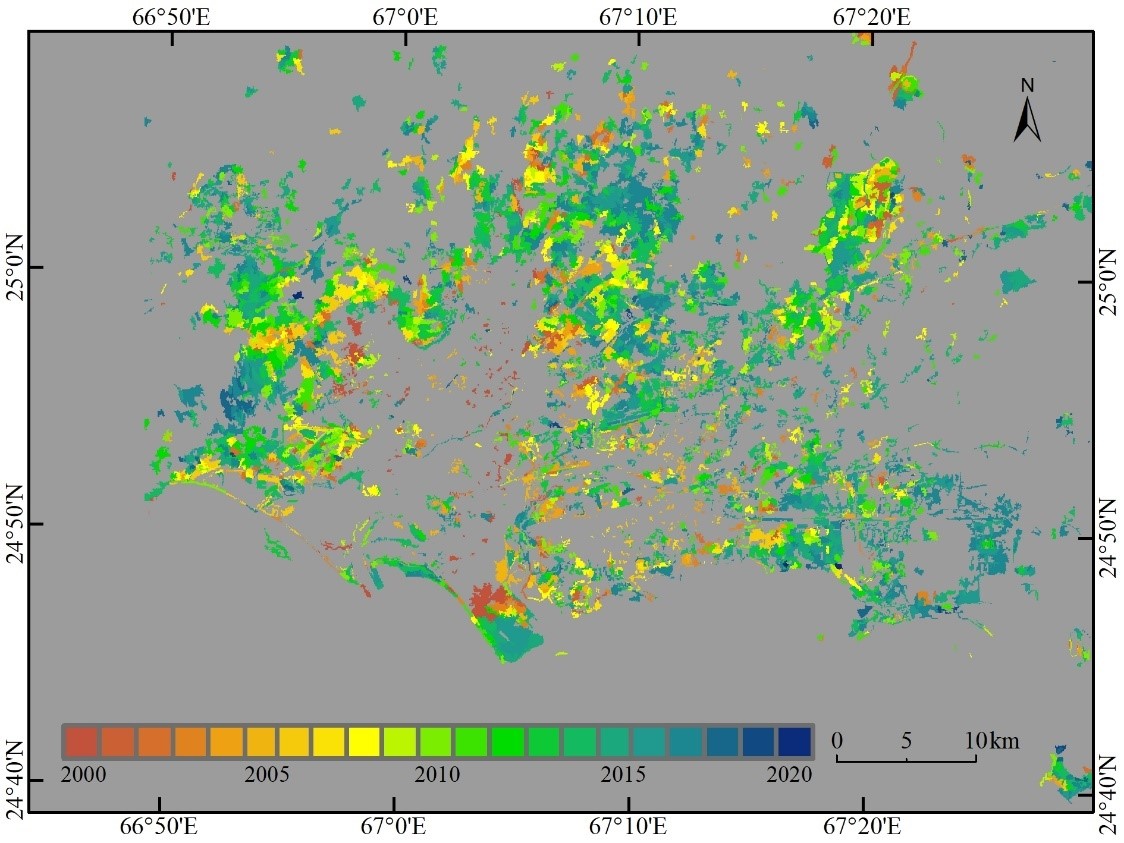
Login   |      Register
English    中文


Surface disturbance (trajectory of Karachi urban expansion) of China-Pakistan Economic Corridor (2000-2020)


Surface disturbance (trajectory of Karachi urban expansion) of China-Pakistan Economic Corridor (2000-2020)

Label :

Date: 2021-10-22

View counts: 2306

Browse document: Browse document

Download Dataset: Log in

This data set is the surface disturbance (trajectory of Karachi urban expansion) of the China-Pakistan Economic Corridor from 2000 to 2020. It mainly records the expansion time of the urban built-up area. There are 9883 records in 1 .shp file. They are produced by the Institute of Geographical Sciences and Natural Resources Research of the Chinese Academy of Sciences and can be used for urban expansion studies to provide a basis for the urbanization research of Karachi, Pakistan.

Topicategory
Earth science
Time begin
2000
Time end
2020
Organization
Institute of Geographic Sciences and Natural Resources Research, Chinese Academy of Sciences
Date creation
2021.09.25
Contributor agency
Institute of Geographic Sciences and Natural Resources Research, Chinese Academy of Sciences
Contributor email
ikcest-drr@lreis.ac.cn
Country id
PK
Data citation
Data set of surface disturbance (trajectory of Karachi urban expansion) of China-Pakistan Economic Corridor (2000-2020). Disaster Risk Reduction Knowledge Service of International Knowledge Centre for Engineering Sciences and Technology (IKCEST) under the Auspices of UNESCO, 2021. 09.25.
Data record num
5.17 MB
Resperson name
Service group of Disaster Risk Reduction Knowledge Service System of IKCEST
Responsible address
A11 Datun Road, Chaoyang District, Beijing
Responsible email
ikcest-drr@lreis.ac.cn
Responsible postcode
100101
Responsible telephone
010-64889048-8006

Data Visualization on Map

Central point longitude
67.072181
Central point latitude
24.932106
Max zoom level
9
Min zoom level
1
Current zoom level
7


    Sign in for comments!

Comment list ( 0 )