1. Opening—Talking about WebGIS
1.1. Preface
I believe that you are already very familiar with Baidu Maps, Google maps and other related applications., we can browse maps, locate our own locations, find the points of interest we want to know, search for traffic routes with these apps, and more. In fact, these functions are some of the most basic functions of WebGIS.
So what is WebGIS, so I would like to start by telling you what GIS is.
1.2. Introduction to GIS
1.2.1. Noun Interpretation of GIS
System, Chinese full name is Geographic Information System. It is a technical system for the collection, storage, management, operation, analysis, display and description of relevant geographical distribution data in the entire or part of the Earth’s surface (including the atmosphere) in space, supported by a computer hard and software system.
1.2.2. What is GIS discipline?
Putting aside these obscure words, I’m trying to introduce the GIS discipline to you in a more vivid way.
We human beings have been using sheepskin or paper maps for a long time, the main purpose is to guide people on marching, sailing, etc., which is also one of the most basic functions of GIS in modern GIS disciplines. By the 19th century, the discipline of modern GIS began to sprout slowly. Here is a very famous example. In 1854, a cholera outbreak in London killed 500 people in 10 days. Most residents suspect that the plague was caused by the underground tombs, which causing great social panic.Dr. Snow, a famous doctor at that time, did not believe this. In order to find out the true source of cholera, he first mapped London, then marked out the location of all the cholera patients. Then he found an interesting phenomenon, with the largest number of cholera patients near a drinking well in london, and the first cholera patients were also found there.Finally, Dr. Snow examined the well and identified the source of the cholera outbreak. From this example, we can see that the application of maps is no longer limited to navigation, but began to slowly take advantage of its unique time-space advantages to begin to combine with other disciplines.
In the 20th century, with the emergence of computers and the breakthroughs of satellite technology,the discipline of GIS began to mature and popularize accordingly.In the 1960s, Canadian scientists first proposed the GIS discipline. By the end of the 20th century, a large number of excellent GIS software had emerged, such as Esri’s ArcGIS series and MapInfo’s MapInfo.Domestic GIS started in the 1980s, but by the end of the last century, its own GIS company appeared, which is well-known as GeoStar, MapGIS and so on.
At this time, GIS is no longer limited maps on paper, which has become a new discipline in which computer technology and various disciplines intersect.It involves measurement—the collection of geographic information and the production of maps, computer science—the production and presentation of electronic maps, and the realization of various GIS functions, physics—the study of sensors and spectra and images. Meteorology - the impact of the atmosphere on satellite imagery, biology, medicine, criminology, etc. - Study the influence of time and space factors such as geography on these subjects.
What is GIS, the most easy to understand is that the surveying and mapping of GIS,generate paper maps or aerial photographs,and after satellite image generation,store these data in the computer,display them in the form of maps or pictures,then provide specific processed data according to the actual production and life and various needs in scientific research.
1.3. Introduction to WebGIS
1.3.1. What is WebGIS?
Since the 1980s, a large number of GIS software are basically C/S architecture, which means that professional GIS software needs to be installed on the machine first, and then users can use these GIS software according to their needs.Of course, this desktop-side GIS software has its natural advantages, such as relatively simple development, do not need Internet support, as well as can do more complex functions, response relatively quickly and so on.But at the same time, its shortcomings cannot be ignored. The first is that it is not easy to promote, and the reason for the inconvenience is that the C/S system has its own natural disadvantages: not easy to update, not easy to cross-platform, not easy for users to use without installing the specified client.
Since the beginning of this century, the Internet has entered an explosive growth stage, and the laying of the network and the increase of the network speed have increased substantially, which provides a solid environment for the development of WebGIS.As a result, more and more GIS systems based on B/S are beginning to provide services,and with the emergence and maturity of RIA (rich client) technology and AJAX (dynamic web page) technology, WebGIS can basically show the same effect and function as C/S. The great development of WebGIS is the demand of users,the large-scale expansion of service providers such as Google Maps and Baidu Maps is the best proof.
What is WebGIS, which shows the functions of GIS to users with B/S technology, so that users can use these GIS functions only on browsers.
1.3.2. Understanding of the domestic WebGIS industry
At present, companies using WebGIS technology can be roughly divided into two directions: one is the direction of the Internet, the other is the direction of industry applications.
The domestic Internet direction has been monopolized by Baidu map, Soso map, Gaode map basically.So for WebGIS developers who want to work in the Internet direction, there are not many large companies that can be chosen. However, if you are a WebGIS developer who is interested in large data and distributed systems, you are strongly advised to go to these Internet companies, where you can get access to the latest IT technologies and feel a strong brainstorming. That is to say, it is a good choice to go to Internet companies for new technologies and people who pursue more frontiers.
But we have to admit another reality. These Internet companies are basically concentrated in Beijing,Shanghai,Guangzhou,Shenzhen, and the technical needs of GIS researchers and developers are that the proportion of computer technology is far greater than the proportion of the theory of GIS discipline itself.Therefore,more people of GIS discipline background, the last choice is the industry application company. Is there no future for a company like this? The answer is No.
Esri, as the most successful GIS software company in the world, gives this answer very well. Esri’s AO library is now known as the world’s second largest library, except Microsoft’s Framework.It is also a company with an annual profit of $800 million. Esri’s cooperation with the governments of the United States and Canada can be regarded as a model of industry companies, which has contributed a lot to the construction of digital cities in these two countries and has produced many outstanding works. This example is just to show that the demand of our digital city is getting deeper and deeper, the needs of the government is becoming more and more practical, the market construction of the whole country is becoming more reasonable, fair and transparent, the application of WebGIS in the industry will be more and more extensive, and more and more able to serve governments, businesses and people,and better to make products of real value.Moreover, with the deepening understanding of the industry, R&D personnel engaged in industry applications may benefit much more in the future than the pure improvement of technology.You know, the project needs analysis depends on the basic industry understanding,of course,the understanding of technology also provides a guarantee for project feasibility analysis. The two complement each other.
Everyone pursues different, according to their own needs, according to their current situation, make choices, persevere, not to say whether the dream can be realized, at least you will not be a person who thinks that they should live so mediocre.
1.4. Framework of WebGIS
There are too many non-technical words mentioned before. Here we begin to talk about a technical topic - the framework of WebGIS. In fact, the Framework of WebGIS is not much different from that of other Web projects. Perhaps the only difference is that WebGIS needs to provide some mapping functional services. Here I will give the framework first, and I will outline the technology needed at each level.
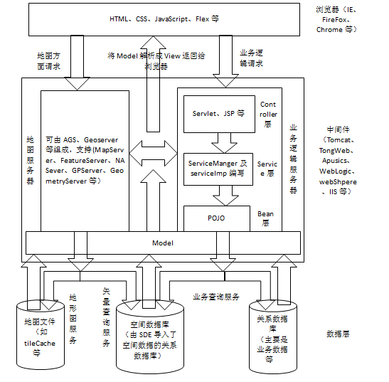
1.4.1. Front end
Like all Web projects, the front end consists of HTML, CSS, JS, Flex and other languages. According to the requirements and the characteristics of the language, it is very important to choose the appropriate language for development. There is no best language, only the most appropriate one.
1.4.2. Background program
1 Middleware
When developing, we should choose the middleware that suits us. Different middleware has its own characteristics.If it is a general project, Tomcat and other middleware are very suitable,it is easy to use, and relevant technical support and information are also very easy to find.But if it’s a large cluster project,Weblogic and WebShpere may be better choices, but the two middlewares are difficult to configure first,and different versions may have problems with the support of some jars.TongWeb and pusics are good choices if the project must use domestic middleware.
2 Map server
In WebGIS, the map server is reflected in the map server, which is distinctly different from other general Web engineering.General map servers are provided by existing software vendors,the more popular agS, Geoserver, MapServer, SuperServer and so on.We can achieve the release of maps and support for some spatial queries and space operations with these map servers.
3 Business Server
Business servers are an indispensable part of Web projects.Regardless of which existing frameworks are used,such as Spring, Struts, Hibernate, etc.,we generally divide the implementation of business servers into three levels,namely,the well-known MVC model.In different frameworks, the realization of these three levels is different.
1.4.3. Data
WebGIS data can be roughly divided into three types, one is map, image data, one is spatial attribute data, and the other is business data. Maps and image data are generally composed of some data in png or other formats.
An important concept in GIS is image pyramid. The main purpose of this concept is to speed up the display of maps at the front end. When we prepare map and image data, we usually cut these data first.
Spatial attribute data, which put the organized data into the library through some tools. For AGS, only the mxd that is connected to the inbound data can be published as a FeatureServer service for data editing. Of course, spatial data can also be used to support the use of business logic.
The third type of data, business logic data, which is required for each Web project.It collects and stores the data required by the business according to different business needs.
1.5. Talking about the principle of WebGIS
At present, many companies have provided their own secondary development kits,in the front-end are OpenLayers,AGS API for JS/Flex,etc.,in the background are geoTools,AO and so on.We can quickly realize the map and many GIS functions with these development kits,basically without writing too much coding.
However, due to the excellent encapsulation, many principles of WebGIS have been neglected and not understood.
Here,I hope to use my weak knowledge to discuss some common principles of WebGIS with you.I hope you will support me.
1.6. Impression
Because of my weak theoretical and technical foundation,I can not say that there is a great prediction for the future of WebGIS,I just hope that each of us will strive to be a perfectionist and a saintly person so as to fulfill our goals, make progress with you,keep my writing motivation and accumulate experience and knowledge.