The concept of gale
Gale means powerful wind. Meteorology now refers specifically to the category 8 wind. During the gale, the branches on the land break, and great resistance to walk in the wind; on the sea, the ships near the harbor need stay. Equivalent to wind speed 17.2 20.7m/s.
Emergency points
(1)In windy weather, when walking near the construction site, the construction site should be as far away as possible and pass quickly. Don't stop under tall buildings, billboards or trees.
(2) Timely reinforcement of windows, doors, enclosures, shelves and other buildings easily blown by the wind, and proper placement of outdoor articles vulnerable to wind damage.
(3) Drivers of motor and non-motor vehicles should slow down.
(4) Stop outdoor operations such as high altitude and water immediately; stop outdoor collective activities immediately and evacuate personnel.
(5) Do not park the vehicle under the tall buildings and trees, so as to avoid the damage of the car body caused by the blowing down glass and branches.
What are sandstorms?
Sandstorms are the general term of both sand storm and dust storm, which refers to the severe wind-sand weather phenomenon in which strong winds blow a large amount of dust material into the air, making the air especially turbid and the horizontal visibility less than 1 km.Among them, sand storm refers to the sand storm formed by strong wind blowing a large number of sand particles into the near stratum, while dust storm refers to the storm formed by strong wind sweeping a large number of dust and other fine-grained materials into the high altitude.
Types of sandstorm weather
Sand-dust weather can be divided into five categories: floating dust, blowing sand, sandstorms, strong sandstorms and extra strong sandstorms.
(1) Floating dust: Dust and fine sand float uniformly in the air, making the horizontal visibility less than 10 km.
(2)Blowing sand: The wind blows dust and sand on the ground, making the air quite turbid, and the horizontal visibility is less than 1 to 10 km.
(3) Sandstorms: Strong winds blow up a large amount of dust and sand on the ground, making the air very turbid and the horizontal visibility less than 1 km.
(4) Strong sandstorms: The strong wind blows up the dust and sand on the ground, making the air very turbid and the horizontal visibility less than 500 m.
(5)Extra strong sandstorms: The strong wind blows up a lot of dust and sand on the ground, making the air especially turbid and the horizontal visibility less than 50 m.
Formation conditions of sandstorms
(1) Sand and dust substances on the ground: This is the material basis for the formation of sand and dust storms.
(2) Gale: This is the dynamic basis for the formation of sand-dust storms and the power guarantee for the long-distance transportation of sand-dust storms.
(3)Unstable air condition: This is an important local thermal condition. Sandstorms often occur in the afternoon and evening, which illustrates the importance of local thermal conditions.
(4)Drought climate: Dust storms occur mostly in spring in the north, and there is good evidence that dust storms do not occur for a period of time after rainfall.
Source path of sandstorms
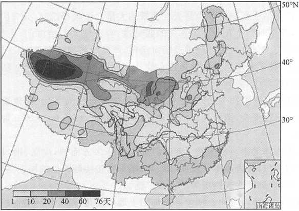
Due to its unique geographical environment, northwest China is also an area where sandstorms frequently occur, the main source areas are Gurbantungut Desert, Taklimakan Desert, Badain Jilin Desert, Tengger Desert, Ulanbuh Desert and Maowusu Sandy Land.
Due to its unique geographical environment, the northwest of China is also an area where sandstorms frequently occur, the main sources are Gutesha Bay, Taklimakan Sand Bay, Badain Jilin Sand Bay, East Gresha Bay, Granb and Shawan and Ganquan Sand Bar.The sand-dust weather paths in China can be divided into northwest, west and north paths.The northwest route 1, dust weather generally originated in the central and Western MongolianPlateau or the Alxa Plateau in Western Inner Mongolia, mainly affecting northwest and Northern China. The sandstorm weather originated in the south of Mongolia or the middle and west of Inner Mongolia, mainly affecting the eastern part of Northwest China, the northern part of North China and most of Northeast China.
On the West track, the dust weather originated in the Gobi area in southwestern or southern Mongolia and the desert area in Western Inner Mongolia, mainly affecting northwest and North China.Along the northward route, the dust weather generally originated in a vast area south of Ulan Bator, Mongolia, and mainly affected the eastern part of Northwest China, most of North China and the southeastern part of Northeast China.There are four high incidence areas of dust storms in the world: Central Asia, North America, Central Africa and Australia. Northwest China is a part of the high incidence area of sandstorms in Central Asia.The total area of desert, Gobi and desertified land in China is 1.689 million km2, accounting for 17.6% of the total land area, mainly distributed in Xinjiang, Gansu, Qinghai, Ningxia and Inner Mongolia (Fig. 6-6).
Comment list ( 0 )

