
Overview of 3S Integration
3S technology provides a new generation of observation means, descriptive language and thinking tools for scientific research, government management and social production. The combination and application of 3S is a natural development trend. The interaction among the three forms a framework of “one brain and two eyes”. That is, RS and GPS provide or update regional information and spatial positioning to GIS, and GIS carries out corresponding spatial analysis (Figure 12-9), in order to extract useful information from the vast data provided by RS and GPS, and integrate them comprehensively. Make it a scientific basis for decision-making.
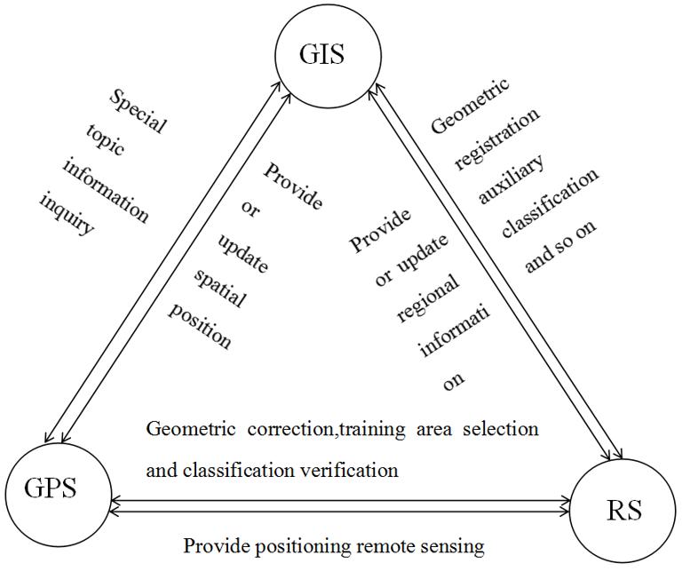
Figure 12-9:3S Interaction and Integration
The integrated utilization of GIS, RS and GPS forms an integrated, real-time and dynamic operation system for earth observation, analysis and application, which improves the application efficiency of GIS. In practical applications, it is common to integrate 3S between two systems, such as GIS/RS integration, GIS/GPS integration or RS/GPS integration, but there are few examples of integrating and using 3S technology at the same time. The surveying and mapping vehicle developed by Ohio University and highway management department is a typical 3S integrated application. It combines GPS receivers with a stereo vision system on the vehicle, travels on the highway to obtain the environmental data of the highway and its sides, and stores them in the GIS database immediately and automatically. The stereo vision system installed on the surveying and mapping vehicle consists of two CCD cameras, which are exposed once a second during the course of moving, and a pair of images are acquired and stored, and processed automatically in real time.
The integration of RS, GIS and GPS can be realized at different technical levels. The simplest way is to use the three systems separately and synthetically by users. Furthermore, the three systems have a common interface to achieve seamless integration on the surface, while data transmission is integrated by signature in the interior. The best way is to integrate as a whole and become a unified system.
From the point of view of software implementation alone, there is not much technical obstacle in developing 3S integrated system. At present, the technical scheme of general tool software is to integrate with remote sensing by supporting raster data types and related processing and analysis operations, and to integrate with GPS by adding a dynamic vector layer. For 3S integration technology, the most important thing is to use remote sensing and global positioning system synthetically in the application, make use of their real-time and accurate data acquisition ability, reduce application costs or achieve some new applications.
With the development of 3S integrated technology, a comprehensive and complete earth observation system has been formed, which improves human’s ability to understand the earth. Accordingly, it expands the research field of traditional surveying and mapping science.At the same time, it also promotes the development of other related disciplines, such as Geo-information Science and geo-information science, which become the theoretical basis of the concept of “digital earth”.
- 1
* IKONOS satellite was successfully launched in 1999. The high resolution remote sensing data provided by IKONOS satellite has good application prospects.
- 2
* In May 2000, the U.S. cancelled the SA policy, so that the single point positioning accuracy can reach 20-30 meters.
- 3
* Geomatics and other disciplines are introduced in the chapter “Geo-Information Science and Digital Earth”.
