Commercialization of Space Remote Sensing
Contents
This second page, prepared by the writer (NMS), expands upon Bill Stoney�s presentation by looking at other aspects of remote sensing as these now have given rise to significant privatization or commercialization of the field as it continues to grow through both aerial and space observing systems. The germane point: remote sensing has become a business, not just an endeavor by governments to demonstrate the value of going into space to learn about the Earth.
Commercialization of Space Remote Sensing
The shift from government programs for space platforms mounting remote sensors to programs devised and funded by private industry has been slow and only now, after 25 years since Landsat 1, has commercialization begun to take off. This contrasts with one of the first space programs developed by NASA aided by other federal agencies: namely, communications satellites, which with the incorporation of Comsat began in just a few years to assume a lead role in which development and funding from industry became the mainstay. Launch vehicles (i.e., rockets) also were built by commercial firms to put private satellites into space. For much of this period, earth resources satellites as well as most meteorological satellites remained the province of governmental sponsorship and control.
The success of the Landsats prompted other governments across the world to underwrite ventures into satellite remote sensing. Some of these branched into the private sector in time. The SPOT program developed by the French, with first launch in 1986, soon thereafter became the pervue of a commercial corporation. The Indian government began its IRS program in 1988. The European Space Agency (ESA) actuated its ERS-1 and -2 operational satellites beginning in 1990 as did the Japanese Space Agency (NASDA), with JERS-1 the same year. The Canadians entered the picture with their Radarsat in 1991. In all of these the governments developed and launched the satellites but either created or arranged with private corporations for the operation of the data gathering and distribution system. Perusal of some of the tables presented in this section indicates that governments are still key players in recent and impending launches of an ever-increasing variety of space platforms and sensor systems. But these tables also point to the expanding role of industry, as indicated by the planned launches of 4 or 5 privately funded satellites by the end of 1998. These satellites will provide for the first time the high resolution imagery which the industry believes is the key for economically successful earth sensing satellite ventures.
In the early days, the principal users of civilian remote sensing data (aside from the military who have always been involved in surveillance systems) in the U.S. were government agencies, state agencies, and academia. Gradually, industry came to recognize the basic value of the synoptic coverage afforded by space systems and started to purchase data in abundance.
To handle dissemination to all kinds of users, the Dept. of the Interior through its U.S. Geological Survey established the EROS Data Center in Sioux Falls, S.D. Its primary sales were a mix of Landsat data and aerial photography. NOAA continued to supply meteorological remote sensing output that rapidly began to effect forecasting and presentation of weather changes appearing in newspapers and on radio and TV.
A number of companies offering value-added services, mainly to industry, emerged starting in the 1970s. One familiar to this writer is the Earthsat Corporation in Rockville, MD, which could provide a wide range of capabilities including a full analysis of a given application problem. Others concentrated on providing software for image processing and analysis to be performed at the customer’s facility. ERDAS in Atlanta, GA. was one of the first in this field. Many other software programs have been developed since the 1970s, some by commercial firms and others by universities (e.g., IDRISI, used in this Tutorial; developed in the Geography Department at Clark University). As GIS grew into a major means of handling geospatial data and solving problems related to siting, land use, environmental monitoring, etc. a few companies, such as ESRI (Environmental Systems Research Institute) and Arc/Info sprang up to offer services and since then many more have joined in providing powerful programs that convolve GIS operations with image processing tools.
Some indication of the breadth of services now available from commercial organizations can be garnered from at the lists and ads in the Green Book: Who’s Who in the GeoTechnologies, published each year by EOM, Aurora, CO (http://www.eomonline.com).
The first push to privatize remote sensing is traceable to some key historical dates in the Landsat program. (This is treated in some detail in the Landsat Chronology put together by Ed Sheffner at the Ames Research Center [NASA], at: http://geo.arc.nasa.gov/sge/landsat/lpchron.html.) In 1979, NASA relinquished operation of its Landsats (Landsat-3 had been launched by then) to NOAA. At the start of the Reagan administration, the drive for commercialization was accelerated. During 1984, the Dept. of Commerce set into motion procedures for privatizing remote sensing in those areas under conditions that did not conflict with military interests. Out of this, an agreement was reached in 1985 for the newly incorporated Eosat in Landover, MD, formed by Hughes and RCA, to operate the Landsat program for 10 years while EROS continued in its role as the National Archive for all land images. However, in 1992 a government decision was made to return the development and launching of Landsat-7 to the Dept. of Defense in cooperation with NASA; DoD opted out of the program by 1996 and Landsat-7 was dovetailed into the EOS/MPTE program. By 1996, however, Landsat-7 had reverted to NASA to operate, with its data to be distributed by an EOSDIS facility built at the EROS Data Center to handle the distribution of the multi-terrabytes of data that will ensue from the MPTE program. It is noteworthy that Landsat-7 will be the first satellite ever to be programmed to gather and archive complete global land scene sets several times a year. The commercial entities’ policies are generally to acquire only scenes ordered by customers.
To assure that commercialization will continue on a parallel course with this and other government programs, an important workshop entitled The New Millenium Program was held at JPL in 1996 to foster coordination of government and private industry in those aspects of remote sensing that rely on expensive spacecraft to gather data.
The maturation of commercial remote sensing probably began with the Eosat (now SpaceImaging) Corp.’s inception as a business enterprise. Another early player in providing satellite remote sensing services was Earthsat, for years in Bethesda and now in Rockville, MD.
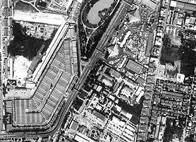
The big breakthrough in making remote sensing products both high desirable and readily available for general and commercial use was the result of the Russian program in the late 1990’s to sell high resolution data on the open market. Prior to that, military restrictions had placed a lower limit on allowable resolution so as to maintain the class of remote sensors that were known as “spy satellites”. The Russians, in need of foreign capital, released many of the photographs taken from space at resolutions of a few meters. In 1998, the Russian space program began to digitize their KR-1000 camera images, then placed these for sale to the entire world. This became known as the SPIN-2 program. Here is an example of a 2-meter image of central Bangkok, in Thailand:
Canada, the Europeans, the Russians, the Indians, and the Japanese all have active remote sensing programs based on satellite observations; their products are available to anyone on a commercial basis. In the U.S., three companies are now (or will soon be) launching their own satellites, usually on commercial rockets: Space Imaging, Inc, Orbital Imaging Corp., and EarthWatch, Inc.. All will produce high resolution, multispectral products, as well as images taken with wide-angle viewing instruments that provide broad area coverage. We have seen several examples of these images in Sections of this Tutorial. As a reminder, here is a SpaceImaging high resolution scene that shows the pyramids outside of Cairo, Egypt.

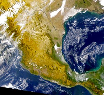
At the other extreme, in which large tracts of land or sea, at subcontinental scales, are depicted in this recent OrbView-2 image that includes most of Mexico:
Still another sign: attendance at any of the rather large number of annual meetings and conferences dealing with both research and applications in all aspects of remote sensing (two of the best known are the ERIM [Environmental Research Institute of Michigan] Conference and the 1-2 meetings sponsored each year by the ASPRS [American Society of Photogrammetry and Remote Sensing) will reveal the growth of commercial remote sensing simply by touring the Exhibit Hall at each meeting. This is prima facie evidence that remote sensing is now recognized as a major venture capital investment whose potential for billions of dollars (worldwide) in business is now being realized. The entry of other nations as providers of remote sensing data shows that the marketplace is truly global. After all, everyone has a vested interest in monitoring the environment, searching for resources, assessing agricultural production, controlling the oceans’ productivity, being constantly alert for dangerous weather conditions and climatic fluctuations, and generally knowing how the land and the seas are being used for (what’s where).
BIG TIME REMOTE SENSING HAS ARRIVED!
BUT WAIT:
You may not be quite validated as a full-fledged remote sensing expert. To reach this exalted status, you need to take a final Exam - a follow up to the one you took at the end of Section 1. This challenging test awaits you on the next page. However, be advised: there are many images, so that those who access this via the Internet, rather than from the CD-ROM, should expect download times of 10 minutes or more unless on a broadband hook-up.
Additional Contact: William E. Stoney (wstoney@mitretek.org)