Remote Sensing of Craters
` <>`__
Prior to satellites with high resolution, much of the searching for impact craters in more desolate parts of the world used aerial photography, if it existed. The Canadian group at the Dominion Observatory found a number of craters that way. With Landsat, SPOT and now much higher resolution IKONOS and other systems, and worldwide coverage, the possibilities for finding new craters have notably improved. To date, at least 10 more have been found with the aid of space imagery. And, special processing such as the enhancements described in Section 1 can bring out new information about a crater imaged by a digital system. This and the last page in this Section contain examples of impact craters as recorded in both aerial and space imagery.
Remote Sensing of Craters
How has remote sensing played a role in the search for or verification of a supposed impact crater? In two ways: 1) recognizing morphological features that are compatible with an impact origin (but this does not rule out certain volcanic craters) and 2) detecting shock-induced changes as spectral changes. The strategy is one of simply using remote sensing to identify landform anomalies consistent with an impact origin and then confirming them by on-site inspection and examination of rocks for shock metamorphic effects. The absence of shock effects leads to ambiguities, making volcanic craters an alternative hypothesis. We have discovered at least four new impact structures through remote sensing.
We can gain a feel for what to look for, and the variations in morphologic expression due to differences in erosional state, at a crater site, by switching again to the Geological Survey of Canada’s Web Page on Impact Cratering). Go to the list of individual craters and check these especially interesting sites: North America: Brent/Clearwater East and West/ Deep Bay/ New Quebec; South America: Araguainha; Africa: Aorounga/ Bosumtwi/Rotor Kamm/Vredefort; Europe: Ries; Asia: Bigach/Popigai; and Australia: Henbury/Wolfe Creek. Another collection of air and space imagery has been compiled by Koeberl and Sharpton as Slide sets.
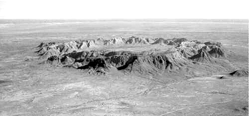
Erosion nearly obliterated the outer sections of the crater, but they are faintly expressed as a dark band in the photo. Field studies show the approximate diameter of the full crater is 22 km (14 mi).
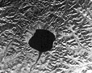
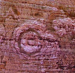
` <>`__18-13: The Elgygytgyn Crater interior, defined by the lake, seems almost squarish rather than round. Speculate on the cause of this departure from the normal inner shape of impact craters. `ANSWER <Sect18_answers.html#18-13>`__

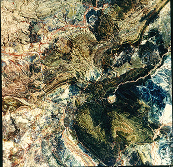
of deformation by Grenville thrusting) and the nearby Wanapitei crater (lake-filled) formed much later.|
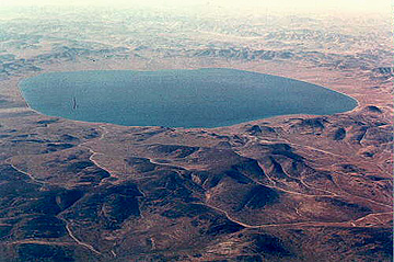
The partially circular lake-filled structure on the right (east) is the 8 km (5 mi) wide Wanapitei crater, estimated to have formed 34 million years (m.y.) ago. The far larger Sudbury structure appears as a pronounced elliptical pattern, more strongly expressed by the low hills to the north. This huge impact crater, with its distinctive outline, was created about 1800 m.y. ago. Some scientists argue that it was at least 245 km (152 mi) across when it was circular. The strong northwestward thrusting of the Grenville Province terrane against the Superior Province (containing Sudbury) subsequently deformed it, more than 900 m.y. later, into its present elliptical shape (geologists will recognize this as a prime example of the “strain ellipsoid) model. After Sudbury was initially excavated, magmas from deep in the crust invaded the breccia filling, to emplace against its walls. Some investigators think that the resulting norite rocks are actually melted target rocks. This igneous rock is host to vast deposits of nickel and copper, making this impact structure a multi-billion dollar source of ore minerals.
` <>`__14: Which part of the elliptical rim of Sudbury seems to have better topographic expression? `ANSWER <Sect18_answers.html#18-14>`__

` <>`__18-15: Where does the crater rim of Haughton appear to be? `ANSWER <Sect18_answers.html#18-15>`__
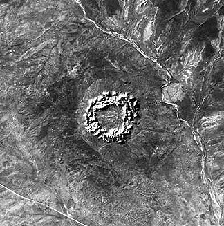
A Radarsat image provides a color view of the newly-discovered Aorounga crater (about 17 km [10.5 miles] in rim diameter found in inclined sandstone units and desert sand in the Sahara Desert of northern Chad.