BASIC SCIENCE STUDIES II: IMPACT CRATERING
Contents
For 10 years, the writer�s (NMS) principal scientific occupation was the study of nuclear explosion craters and their natural counterparts, meteorite (asteroid) impact craters. From the status 50 years ago of “minor curiosity”, impact cratering has now been elevated to be one of the three most important geologic processes. About 150 craters are known on Earth (compared with millions on the Moon that survive because tectonic and fluvial erosion processes have not destroyed them). This second section on scientific uses of remote sensing will delve into three topics: 1) what happens to make a crater; 2) how are impact craters found and recognized, and 3) can remote sensing help to find more? During his remote sensing years, the writer has searched for new ones but has come up empty. However, others have found a few previously unknown craters intially on space imagery. Special processing of images also can reveal subtle details about known craters that add to our knowledge of their size and deformation characteristics.
BASIC SCIENCE STUDIES II: IMPACT CRATERING
Many organizations perform scientific studies using remote sensing that embrace most of the disciplines already considered in this Tutorial. Section 14 on Meteorology is a cogent illustration of a field within the Earth sciences that has a strong scientific-research bent and a broad set of applications. Some applications are direct spin-offs from satellite programs that were initially proof-of-concept efforts. If more in-depth case studies focused on botanical, land use, hydrology, archaeology, etc. were on the Internet (with proper illustrations), then certainly more examples would have appeared earlier in the Tutorial. Unfortunately, there still is a dearth of satisfactory studies on the Net, and calls for contributions through personal contact have met with nil success. So, because of the professional geological background of the writer (NMS), there seems an overabundance of examples of geologic features in this Tutorial, but this results in part from the reality that geologic phenomena are often so dominant in a remotely-sensed scene .
In keeping with that experience, Basic Science II presents another geological subject that also was once my principal specialty - impact cratering. For years, impact cratering was esoteric. Now, impacts are hot topics, especially since they have been identified as the likely immediate cause of dinosaur extinction. More to the point, scientists and the general public now realize that impacts are genuine dangers to mankind, capable of causing catastrophes greater than any other natural process known to affect the Earth’s surface. Plus, they are almost certainly to occur (as they already have) as huge events sometime in the future of civilization. This subject of impacts is pertinent and interesting, and impact craters are often detectable by remote sensing.
` <>`__(An exceptional summary of impact cratering, and especially the record of these events imposed on the target rocks, is a 120 page treatise written by a colleague, Dr. Bevan M. French, and entitled Traces of Catastrophe: A Handbook of Shock-Metamorphic Effects in Terrestrial Meteorite Impact Structures, published by the Lunar and Planetary Institute [Houston, TX]; LPI Contribution No. 954, 1998.)
The Nature of Craters
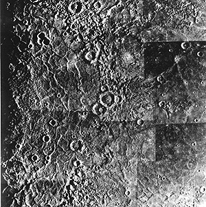
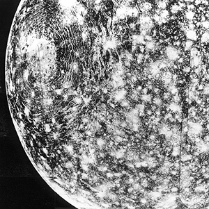
One of the payoffs of the space program is that many people realize that fast-moving asteroids, comets, and large meteorites collide with growing or stable planets during their formative period. Moreover, impacts persist in modifying such bodies throughout their history. The surfaces of some terrestrial-type planets and many of their satellites display craters that totally pockmark their surfaces: Mercury (top) and Callisto (fourth satellite out from Jupiter) are prime examples.
Earth’s Moon has conspicuous craters with generally circular depressions, ranging in size from less than an inch to more than 1,200 km (746 mi) in diameter. Many of the larger ones are visible at full Moon through a pair of binoculars. The most conspicuous lunar impact structure is Tycho (below, on the left) located on the Moon’s southern hemisphere. We can readily see that it is the source of great streaks (rays) almost visible to the naked eye that result from deposits of ejecta hurled across the Moon.
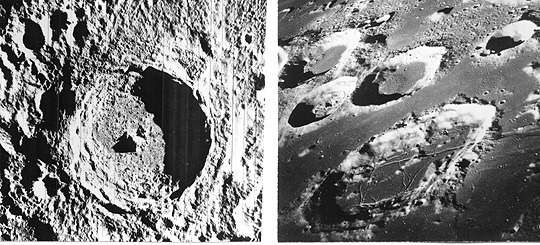
The Tycho crater is the classic exemplar of a large impact structure, with these hallmarks: circular raised rim; concentric nest of slumped walls inside this rim; central (uplift) peak; rough, irregular crater floor (here a mix of fragmental ejecta and lava extrusion); and exterior ejecta in hummocky deposits. Typical of farside craters is Goclenius (55 km, 34 mi wide) and several smaller ones (right) as they appeared to Apollo 8 astronauts circling our lunar neighbor. Note their flat interiors filled with mare lavas.
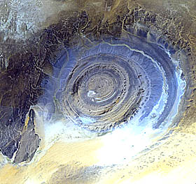
On Earth, circular structures are rare but, as mapping parts of the continents since the early 19th Century led to discoveries of such features, a number had been identified by the middle of the 20th Century. One of particular note is the series of concentric ridges in Mauritania (West Africa) known as the Richat structure (about 40 km outer diameter). The structure was first discovered from space by Gemini 4 astronauts McDivitt and White. This structure results from doming of sedimentary rocks by an igneous intrusion; erosion has left the quartzite ridges as hogbacks (inclined strata that are raised relative to softer rocks between circles) that outline the “bulls-eye” appearance of the structure. Here is a view taken by the ASTER sensor of the Richat structure (which briefly was thought to be of impact origin until a visit by R.S. Dietz found field evidence that precluded that possibility and confirmed a purely internal origin:
Less than 100 years ago, scientists considered the concept of craters (especially those that remain circular) forming by impacts from meteorites and other extraterrestrial bodies (“bolides”), such as comets, unrealistic and highly improbable. Several scientists had, by then, suggested that such craters covered the Moon, but the bulk opinion attributed these to volcanic processes. And, indeed, there were depressions in terrestrial volcanic fields that bore sometimes strong resemblance to lunar craters.
One volcanic type that leads to near circularity of some of the resulting craters is the maar crater exemplified below by the Crater Elegante (1.5 km [0.9 mile] diameter) in the Pinacate basaltic field in northwest Mexico (below the Arizona border). This kind of volcanic crater often has a subdued rim. It is formed when lava encounters near surface water which flashes into steam causing rock overhead to be pushed out explosively leaving a depression that is somewhat backfilled by volcanic fragments (and later debris washed in). The gashlike depressions outside the rim are caused by water erosion.

Another example, shown next, is the elongate caldera on the summit of the raised shieldlike basaltic volcano on Isle Fernandina in the Galapagos Islands. Note the irregularities in its shape and the numerous lava flows emanating from the side of the volcano’s slopes.

` <>`__18-1: Until the space program in the 1960s, debate over the nature of lunar craters raged as a controversy for more than a century. But with close exploration of the Moon and then planets like Mercury and satellites like Callisto disclosed that most planetary surfaces were heavily cratered. The weight of opinion shifted drastically in favor of impact as the dominant process creating the myriads of circular depressions spread widely over these surfaces. Can you develop (deduce) some arguments that support this impact hypothesis? `ANSWER <Sect18_answers.html#18-1>`__
Impact as a lunar and terrestrial process was first suggested by European geoscientists in the early 1800s. The proposal that Meteor Crater in Arizona had an impact origin, opened the possibility of impact as the cause of other, similar, circular features. G.K. Gilbert conceived the idea and then supported it by finding iron meteorites around the crater. Work by R. Baldwin and others kept the impact process alive as an alternative but the vast majority of astronomers and geologists were highly skeptical. All this changed in 1960 with the classic study of cratering mechanics at Meteor Crater and several nuclear explosion craters by Eugene M. Shoemaker, which opened up the possibility of impact as the cause of similar circular features, of which more than 50 were then known on Earth.
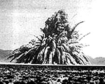
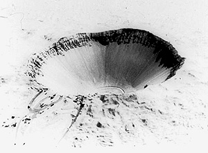
The critical proof emerged in the 1960s from the study of the effects of the intense pressure (shock) waves generated during impact on the target rocks at terrestrial craters, with key studies by E. Chao, W. von Engelhardt, B.M. French and others. In 1960, the writer (NMS), began my studies of nuclear and chemical explosion craters as part of my job in the Plowshare program (engineering uses of nuclear explosions) at the Lawrence Livermore Laboratory (see page 18-4 for further details). I was responsible for determining the changes induced in rocks at the Rainier, Hardhat, Danny Boy, and Sedan nuclear explosion sites. Sedan, in particular, yield quite interesting results because this cratering event was conducted in alluvium that contained granite, sandstone, and limestone “float” (blocks of rock a few inches to a foot in size, carried in by streams), all of which were subjected to strong shock pressures during the explosion. Sedan at that time was the largest cratering experiment yet carried. A 100 kiloton nuclear device produced this 372 m (1230 ft) in diameter crater. Shown below are first the ejecta being tossed out of the developing crater at about 10 seconds after the detonation (I was located about 4 miles east of ground zero, on top of Rainier Mesa [the closest approach of anyone that day], busily snapping color photos that were later helpful in determining the downwind debris history). Below it is the crater itself about a week after the event, when I was allowed to move up to the rim to collect samples:
These underground nuclear explosions generate peak shock pressures of the same magnitudes as are developed during impacts. One would therefore expect to find shock effects in the rocks involved that were similar to those noted at impact sites. And indeed I found that shock metamorphic features in these rocks were identical to corresponding features in impactites (rocks from natural craters). This tie-in led to the argument that only impacts could cause high pressures on the order of those in underground nuclear explosions, as the features produced are never found in rocks associated with volcanism, even the types called “explosive”.
Gradually, the idea that impact is one of the fundamental formative processes acting on planets won broad acceptance. In fact, scientists have now proven that planets grow by accretion of infalling materials, with the craters representing the last stages of buildup, as the planets reach their full sizes. The nature of impact cratering is important, yet introductory geology textbooks still treat the subject poorly. So, this summary comes from the author’s experience in the field.
Heavily cratered planetary bodies, such as the above, share the impact markings that appear on their ancient surfaces but have not been fully demolished or masked by erosion, lava outflow, deposition, or obliterating mountain activity. Cratering on their surfaces was most intense from the last stages of planetary growth, very early in solar system time (beginning about 4.6 billion years ago), through a later period of about one billion years, after which, the flux of objects striking those surfaces dropped off notably. Earth, Venus, and parts of Mars, also profusely cratered at the outset, by contrast now show far fewer craters because of the subsequent destructive processes that erased or covered most of the impact evidence left on the primitive surfaces.
With the return of the first lunar samples from Apollo 11, shock effects in moon rocks were observed, supporting the conclusion that the bulk of lunar craters are the result of impact.
Distribution of Craters on Earth
Earth today, despite its many recyclings of continental and oceanic crust, retains signs of huge impacts imposed in the last two billion years, as well as smaller ones that took place in historic times. Scientists have found about 160 surviving craters of definite or probable impact origin. This is well below the estimates of tens of thousands that we would expect, if Earth’s surface and crust had not experienced such dynamic ruin from plate tectonic action and atmospheric-driven erosion. Also, protection by deep oceanic waters (more than 70% of the planet’s surface) and burial by sediments further account for this deficiency in anticipated numbers. Nevertheless, more craters remain to be discovered, and satellite imagery should be an effective means for conducting a systematic search, as we shall see near the end of this survey.
There are many informative Web Sites on impact cratering. Start with (Terrestrial Impact Cratering), put together by the Lunar and Planetary Laboratory of the University of Arizona. That site has a world map of craters and a good review of the processes involved in impact cratering. Calvin Hamilton prepared a similar treatment, supported by selected images of terrestrial and planetary craters, at (Solar System Cratering). Still another explanatory site is this review of impact cratering by Koberl and Sharpe; this article contains a nearly up-to-date geographic distribution map of known craters, plotted by size groups, which is reproduced below. A simple listing of craters, with location, size, and age, can be brought up from the Internet simply by pressing any of these three sites (active as of August 2002): (1); (2); and (3).

We can also display the map by individual continent, after accessing this site. For each continent, the craters have names and you can click on these for a description and, often, an aerial view, along with their precise geographic coordinates, size, and estimated time of formation.
` <>`__18-2: Inspection of the above distribution map shows large areas on Earth in which confirmed impact craters are absent or sparse. Offer several explanations for this scarcity. `ANSWER <Sect18_answers.html#18-2>`__
For anyone seeking a comprehensive and technical treatment of crater mechanics, we recommend the book “Impact Cratering: A Geologic Process,” by H.J. Melosh, 1989, Oxford Monographs on Geology and Geophysics No. 11, Oxford University Press.