Atmospheric Sounders
Contents
This page is divided into two main topics. The first half deals with specialized instruments onboard some metsats that are capable of taking readings or “soundings” through the atmosphere at various depths to produce profiles of such variables as temperature, water content, CO2, etc. From these maps of atmospheric properties at various elevations can be constructed. The second part considers the two main categories of meteorological satellites: those that follow near-polar orbits and image strips along their pathways and those placed at about 37000 km (22000 miles) in geostationary orbits (at the equator, the satellite moves at same velocity as the Earth�s surface beneath it). By placing a small number of geostationary satellites at different points above the globe, the whole Earth can be monitored simultaneously in real time for its moving weather patterns. A generalized system of groups of orbiting satellites is described.
Atmospheric Sounders

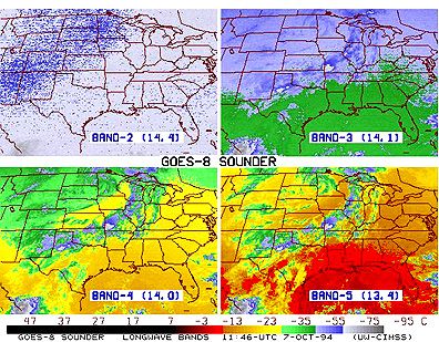
One way in which a sounder can sense levels in the atmosphere is illustrated in the diagram below. Each temperature map was made at a specific wavelength that is capable of measuring the radiant temperature in the atmosphere at some particular altitude (or depth within the air column, which can also be expressed in terms of atmospheric pressures in millibars). The map progression from upper left to lower right follows a trend of decreasing height above the surface. Note especially in the lower pair that the lateral temperature variation is from cooler in the northwest to warmest in the southeast.
Soundings can also be made in the microwave region. At different frequencies (or wavelengths, especially in the millimeter range), the return signals give blackbody-equivalent temperatures at different depths.
However, because satellites sweep over much of the Earth, particularly those in near-polar orbits (see below), and thus, take data readings continuously as they orbit, we can present the sounding data as global maps. As an example, consider these maps of global temperatures at four different altitudes (specified as pressures in millibars), as obtained by the TIROS Operational Vertical Sounder (TOVS) on Nimbus 12 on April 15, 1997 (115 mbars is approximately at 15 km and 950 mbars is near the surface):
|
|
|
|


We display a number of similar maps made from atmospheric sounder instruments on metsats elsewhere in this section.
` <>`__14-6: For a location on the equator, from the above 4 image panels, estimate the temperature profile on this infamous date (April 15, 1997, when much additional heat was probably added to the atmosphere from irate taxpayers). **ANSWER**
We can only scratch the surface (really, the atmosphere) on this subject of metsat instrumentation. For example, the Nimbus series actually supported 24 different experimental systems, involving a variety of sensors. The interested user should consult Kidder and Vonder Haar.
Classes of Metsats
From this method, we can make a daily mosaic from the swaths, which is a good general summary of global weather patterns for that period. This same orbital configuration applies to Landsat, SPOT, and some of the other land observers. Other POES members have inclinations or other orbital constraints, such that they cross equivalent latitudes at different times of day, allowing observations over various times in the diurnal cycle. Most POES orbits are circular to slightly elliptical at distances ranging from 700 to 1700 km (435 - 1056 mi) from the geoid. At different altitudes they travel at different speeds.
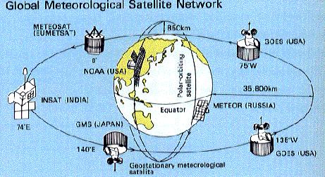
The second type of metsat is in the Geostationary Operational Environmental Satellite (GOES) class. These satellites are geosynchronous, meaning their orbits keep them synchronized with Earth’s rotation, i.e., they take 24 hours to complete one orbit. To have a 24 hour orbital period, they must keep an orbital altitude of 35,780 km (22,234 mi, or about 5.61 Earth radii), which sets their speed at 3.07 km/s (6,868 mph).An equatorial point travels underneath at a speed of about 0.465 km/s (1,040 mph).
When these satellites orbit above the equator, with zero inclination, they are also geostationary (fixed) relative to a point on the equator, so that they observe the Earth without any significant relative motion. At this distance, and with a wide FOV, they see the Earth as a full disk, but the area covered is less than a hemisphere, being about 1/4th of the planetary surface.
The Earth and satellite, synchronized, rotate relative to the Sun, so that part of each day, the satellite’s sensors face the night side. But, because of this night effect, to view the Earth in daylight continuously requires at least three (preferably four) geostationary satellites located equidistantly around the globe above the equator. Under these orbital conditions, the sensors can look at the disk at any moment, gaining a synoptic image, in which it views all meteorological elements in real time. We acquire visible images typically 30 minutes apart and infrared images less often. GOES platforms usually operate in pairs, spacing about 75° apart. We refer to current GOES units above the western hemisphere as GOES-East and GOES-West.
` <>`__14-7: Which type of satellite most likely gives you the cloud movement panorama you see in the nightly TV news? **ANSWER** ****