A Gallery of Photos from Space
Contents
More examples of Shuttle imagery are displayed on this page, along with one picture taken by the MIR station cosmonauts using the KVR-1000 camera capable of 2 meter resolution and a pair of pictures from MIR taken by an American astronaut.
A Gallery of Photos from Space
We now present a gallery of exemplar photos, taken from representative Shuttle and other space missions. Some computer screens pair these images side-by-side but, small screens may display one above the other. Each one has a brief description.
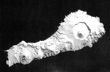
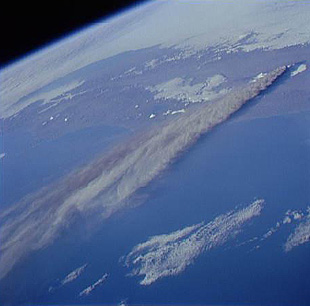
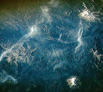
Let’s start with a sequence showing active and recent volcanoes on three continents. In the first pair, on the top is a vertical photo taken during STS-59 that shows a snow-covered island in Russia’s Kamchatka Peninsula (far east Siberia) that has a volcanic caldera at each end, both with a central stratocone. Below it is an oblique scene that traces a long plume emanating from the Kliuchevskoi volcano in that peninsula during an active eruption.
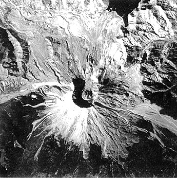
Mount Saint Helens, in southern Washington State, erupted catastrophically in 1980. Astronauts photographed it in 1994, with a Nikon 300 mm lens, during the STS-64 mission, clearly showing the persistent aprons of ash deposits, despite considerable reforestation, lobes of lahars (ash-mud flows), and the great gap where part of the mountain was blown away.
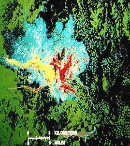
(As an adjunct to this example of space photography that captures so clearly the deposits around Mt. St. Helens, we show here a simple classification of three types of spectrally distinguishable deposits developed from the eruption. Just a few days after the May 18, 1980 eruption, a cloud-free Landsat-3 image was obtained that showed the depositional pattern. As soon as a computer-compatible tape (CCT) was made available to the writer, he and a colleague (Charles Bohn) worked well into the night on the IDIMS image processor at Goddard to obtain this next classification map. The exercise shows that with computerized data of this nature, one can produce meaningful interpretations in a very short time.)
It is interesting to place Mt. St. Helens in context with two other great stratovolcanoes in the Cascade Mountains of the western U.S. These two Shuttle views, one an oblique, false-color IR picture (looking northwest) and the second, a near vertical, natural-color shot, show Mount Saint Helens (MSH) to the west and Mounts Rainier and Adams to the east, all snow-capped. Indeed, MSH is the only volcano that is significantly offset from the main line of the Cascadian volcanic activity. Note the clear-cutting patterns in the forested countryside.
` <>`__12-9: Both of the above photos have rather odd orientations. But the presence of the three great peaks allows one to tie the photos to a map atlas by the classic technique of triangulation. Try to do this. You will know you have succeeded when you find the name of the distinct large lake near Mt. St. Helens (volcano in the center in the top photo).`ANSWER <Sect12_answers.html#12-9>`__
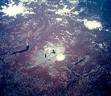
A recent volcano, known as the Pic Tousside, in the Tibesti Mountains in the Sahara of Chad (Africa), is noteworthy because of the insect-like shape created by several basalt flows:

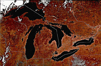
Astronaut photography and geostationary satellites have depicted large areas of the global surface. Observe, on the top, a southwest-looking STS photo of the Great Lakes in the northern U.S. and adjacent Canada. Compare this with a scene extracted from a Nimbus AVHRR false-color image that covers all of these lakes (state and province boundaries are superimposed). Test yourself in identifying each of the Great Lakes.

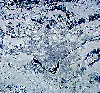
We view cities in context with their surroundings in STS pictures. Below, the top view is Tokyo Bay in Japan (STS-56). Tokyo is in the upper left, and Yokohama is in the lower left. On the right (east) side of the bay are built-up areas that include large landfills bounded by retainer walls, which hold ship docks. Compare Tokyo’s visibility with the winter scene (STS-60) of Montreal in Quebec, Canada (bottom), in which cleared streets stand out against the snowscape, similar to a dusted fingerprint.

In the late 1990s, a new variant of Shuttle Photography was introduced: the EarthKam program. Here the astronauts took photos of targets that were preselected by America’s K-12 grade students. The scene below is an example. It shows the Cape of Good Hope at the southern tip of Africa (south is to the right). The Hottentot Holland Mountains lie above the town of Strand. Note the column of smoke from a possible forest fire.

Astronauts have taken some remarkable pictures from space in the dead of night. In one example, from the Shuttle, the collective lights of cities and towns around San Francisco Bay outline it in orange.

` <>`__12-10: Where is San Francisco itself in this striking Shuttle night view? `ANSWER <Sect12_answers.html#12-10>`__
Although the next image is not a photograph, it ties in with the above San Francisco at night photo, but on a grandiose scale. The Defense Mapping Satellite Program (DMSP) is operated by the U.S. Air Force. One of its sun-synchronous, near-polar satellites took (from an 625 km [516 mile] altitude) nighttime images of the U.S. using a channel operating between 0.4 and 1.1 µm. Under cloudfree conditions in December 1986, the scene mosaic shows only those areas large enough to produce a concentration of light from street lamps, etc. See if you can locate the region in which you live, using the pattern of lights from metropolitan areas near you, Can you tell what accounts for the numerous linear patterns developed over most of the U.S.? How many areas of concentrated light can you identify as urban centers?
U.S.|
` <>`__12-11: If you live in a small to large city, see if you can locate it in the DMSP image. If you live in a more rural setting, try to find the nearest city(ies) to your residence. Many of the larger towns seem linked as beads in a rosary. Why? `ANSWER <Sect12_answers.html#12-11>`__
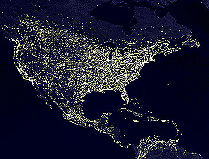
It is instructive to compare the above DMSP image taken in 1986 with another, covering the U.S, southern Canada, the Caribbean, and Central America, and the northern part of South America, taken by a later DMSP in the year 2000. The increase in urban and town development in the western U.S. is especially noteworthy.
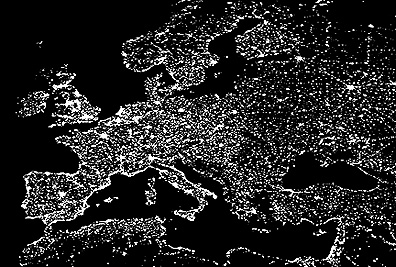
The European continent, and the Mediterranean lands especially, is heavily populated. One would expect many urban and regional centers to be notably “lit up” and thus easily recognized in night imagery. Examine this DMSP image of this part of the world and see how many specific cities you can place and identify.
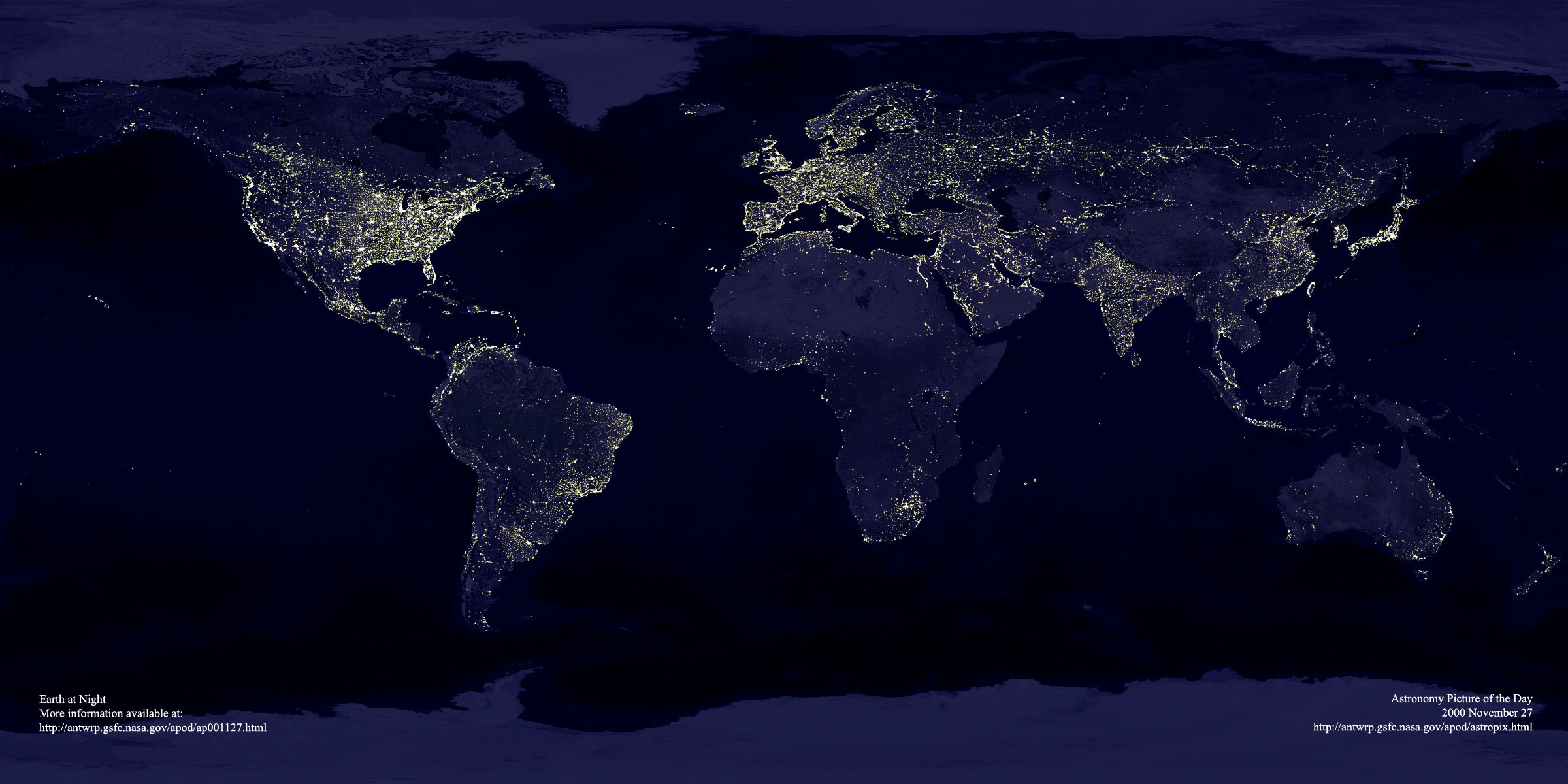
On a truly grand scale, the DMSP has covered the Earth under cloudfree conditions enough times now to allow production of a relative night light brightness map for all the continents of the World. It amounts to a map that also indicates the distribution of population densities. .
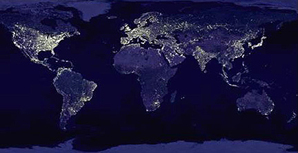
There is a very large version of this global night view of the Earth’s lands and seas that can be accessed on the Internet by clicking here. This is a recent DSMP image. It is big enough for you to see details not evident or hard to discern in the above image. If you decide to download and inspect the scene, we suggest that you do three specific things: 1) try to identify from the light pattern some of the major cities in the world; 2) look about and ask yourself what regions are still either with low population and/or do not have a developed modern infrastructure that includes extensive electrification
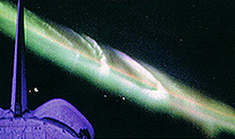
The Shuttle crews always look for terrestrial phenomena around, rather than on, the Earth. Here are a view, from STS-45, of the aurora borealis (also known as the Northern Lights) appearing as spectacular light bands, caused when electrons and other particles from the solar wind strike atoms in the outer atmosphere (see page Intro-1).
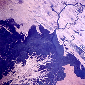
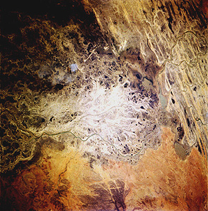
Astronaut Shannon Lucid, participating with the Russians on MIR for an extended mission, took a large number of photographs of preselected targets of special interest. Two that are especially informative are scenes of the inland delta of Niger, in Africa. Almost every year there is enough rain to temporarily fill a basin along the Niger River as shown in the top photo. But, the arid, hot summer climate quickly dries this oasis of water leaving the rather desolate scene shown in the bottom photo. Note the sand dunes.
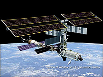
In one sense, the astronauts/cosmonauts are the “ultimate tourists” who take special pleasure and meaning from their phhotography activities while in space. Many of their targets are pre-selected but some are genuine targets of opportunity. Now, with the realization of the International Space Station (ISS) as a functioning platform, many new opportunities will be presented. The ISS has a Science Laboratory Module that includes a dedicated window, with special optical quality glass, through which photographs are being obtained. Here is a view of the ISS with its photo-window, taken soon after the module was attached in mid-February 2001.
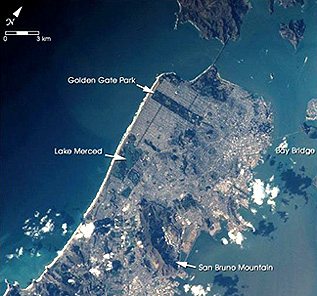
And here is a photo taken in February, 2001 through this window. The scene is the ever-popular target - San Francisco - as it appears from 166 miles away.
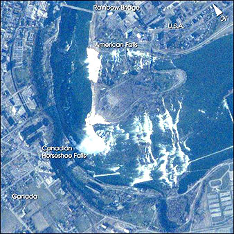
Even more impressive is this ISS photo of Niagara Falls, near Buffalo.
The topics summarized in this Section should, first, point to the unique role of trained humans in space and, second, underscore the value of hand-held photography. A third advantage of pictures from manned missions is their low cost and ready availability compared to those from automated observation satellites like Landsat, SPOT, and similar space imagery, that generate expensive and proprietary products. Fourth, their natural color and their obliquity make many hand-held pictures generally well-suited to educational use, providing easily understood views of the Earth from orbital altitudes. Finally, the photography stands as a record of long-term changes (going back to the 1960s) of the Earth’s surface, whose appearance, as well as its physical structure are continuously changing, sometimes from minute-to-minute.
Nicholas M. Short, Sr. email: nmshort@nationi.net Dr. Paul D. Lowman Jr. (lowman@denali.gsfc.nasa.gov)