ELEMENTS OF AERIAL PHOTOGRAPHY
Contents
The “ancestor” or progenitor of space images like those made by Landsat, SPOT, IKONOS, et al. is the aerial photograph, in common use now for almost a century. And, even today with products from the space systems competively priced, aerial photography remains a powerful and sometimes optimum tool to use for both routine and specialized applications. Two variants of aerial photos, each obtainable in black and white or color, are the vertical (sees Earth straight downward) and the oblique (sees at various angles, usually less than 45�). Photography commonly takes place in the visible but film sensitive to the very near infrared or ultraviolet allows image-taking in those spectral regions. The two main advantages of aerial photography over space imagery are 1) the mission can be flown at any time, weather permitting, and 2) resolution is usually higher (although recent Russian and American commercial products from space are narrowing that gap). Examples of aerial photos of different scales and types are shown.
ELEMENTS OF AERIAL PHOTOGRAPHY
In previous sections, we have used aerial photography to look closer at areas of which we had satellite based images (such as Morro Bay in Section 1). In fact, satellite surveillance is in essence an extension of the concepts underlying aerial photography, taken to higher altitudes that allow coverage of larger pieces of real estate. Space remote sending uses devices that, while much more costly to build and operate, rely on the same physical principles.
Most textbooks on remote sensing are outgrowths of earlier texts that once dwelt dominantly on acquiring and interpreting of aerial photos. New books still include one to several chapters on this basic, convenient approach to Earth monitoring. We shall allot only limited space to explore some essentials of this expansive topic in the present section and the next. In the next section, we consider photogrammetry as the tool for quantifying topographic mapping and other types of mensuration. For anyone with deeper interests, we recommend consulting the reading list in the Overview, and/or going to Volume 1 of the Remote Sensing Core Curriculum website.
Aerial Photos of New Zealand and Harrisburg, PA

` <>`__
` <>`__10-1: For the moment we shall define resolution in a photograph as the size of the smallest object whose tonal appearance is notably different from its surroundings or background; technically there is a more precise definition, given in terms as the minimum spacing between two dark lines embedded in a light background that can be visually separated. How does spatial resolution vary in this oblique photo. `ANSWER <Sect10_answers.html#10-1>`__
The second type of aerial photos is oriented vertically, that is, it results from pointing the camera straight down (to the nadir, at the photo center point) to show the surface directly from above. The size of the photo and the sizes of the features represented within the photos can vary depending on the following: the camera’s optical parameters, the surface area of the exposed film (frame size), the subsequent printing sizes (e.g., enlargement), and the altitude of the camera platform.
Image Scale
The ratio of the size of any object, feature, or area within the photo to its actual size in the picture is called the scale (defined and discussed on the third page of this Section).
We now present a series of aerial photos, acquired at different times and scales, most covering areas that lie within this June, 1977, Landsat image (scale = 1:1,000,000) of south-central Pennsylvania, a scene we have looked at in earlier sections, and especially during the Exam at the end of Section 1.
Harrisburg, originally printed at a 1:1,000,000 scale.|
This scene contains heavily forested fold ridges. Some of the bluish-black areas are defoliation patches caused by the Gypsy Moth. Others areas near top center are surfaces covered with black dust from the Anthracite coal strip mining in fold valleys. Bluish areas in the wide valleys are fields still bare or with early stage growth. The Susquehanna River which empties into the top of Chesapeake Bay bisects the image. Near the left center, a blue pattern with spokes is Harrisburg, the state capital, with York below it and Lancaster to the right. Next, we show a standard medium-scale ( moderate area of coverage but with considerable detail [individual buildings still visible]), black and white aerial photo of part of Harrisburg. The scale value given is that of the original photo before it was reduced to your screen size; quoting this value helps to appreciate what can be seen (resolved) at that scale, no matter what the eventual picture size becomes through enlargement or reduction.
city of Harrisburg (right) and towns across the Susquehanna River to its west.|
Harrisburg (Scale = 1:100,000)
The number in the upper left corner of this black and white photo of Harrisburg is the date; on the right is the Mission number; and in center is a number denoting the flight line and particular photo within that line. Individual fields, smaller rivers, bridges, and roads are easily picked out.
` <>`__10-2: One meaning of scale is this: 1 inch on the photo equals X inches on the ground. For the 1:100,000 photo above, determine how many feet are represented by an inch (on the photo, or in this case, the image on your screen) and likewise how many mile(s) extend across that inch. `ANSWER <Sect10_answers.html#10-2>`__
The next photo is large scale (small coverage area and high resolution for identifying features smaller than buildings, e.g., cars) and covers an area within Harrisburg, just east of the previous photo, bisected by Interstate 83. Note particularly the lake-filled quarry (left center).
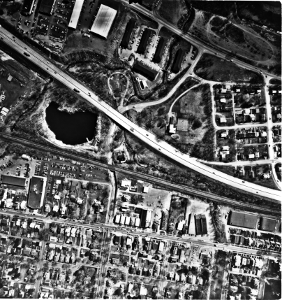
Urban Harrisburg (1:4,000)
` <>`__10-3 In which other photo on this page can you find the quarry lake? For the above photo, what is/are the number of miles represented by an inch on the screen? Make an educated guess as to the effective resolution of this 1:4000 photo; how did you do it? `ANSWER <Sect10_answers.html#10-3>`__
In the lower right corner of the Landsat image is an agricultural area along the Chesapeake and Delaware Canal. Its expression in a moderately large-scale, natural-color photo is shown here:

Natural Color Photo (1:24,000)
At a still smaller scale, we next show a false-color, IR image of the Susquehanna Water Gap passing through Blue Mountain just north of Highway 81 (bottom of the picture) that, to the east, runs along the north side of Harrisburg.
Color IR Photo (1:8,000)
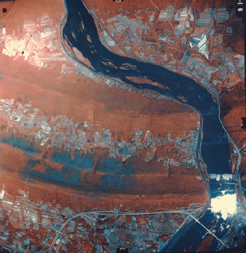
Much the same area is part of a small scale (large area coverage with reduced detail) aerial photo obtained from an RB-57, NASA aircraft, flown at an altitude near 15,200 m (about 50,000 ft) on February 5, 1974. On this date, the color-IR photo shows limited red tones from fields in which winter wheat is growing. The image is 25.2 km (15.7 mi) on a side (635 square km; 246 square mi).

High Altitude Aerial Photo (1:141000)
` <>`__10-4: There is an easy way to determine whether a scale is large, medium, or small, by looking at its stated value, e.g., 1: 30,000. Propose a simple rule for this. `ANSWER <Sect10_answers.html#10-4>`__
Two internal characteristics establish the pictorial content of an aerial photo (as well as space images): tones and tonal variations (as grays or colors) and patterns made by these. These, in turn, depend on the physical nature and distribution of the elements that make up a picture. We need, at this juncture, some basic insight into how a photo is made.
Primary Author: Nicholas M. Short, Sr. email: nmshort@nationi.net | Collaborators: Code 935 NASA GSFC,