The First ERTS Image: Dallas-Fort Worth; Archaeologic Wonders
Contents
This section ends with two “miscellaneous” historical curiosities: The crude image of the Dallas-Forth Worth area that was the first to be produced at the Landsat Image Processing facility at Goddard Space Flight Center, and so new to the 100+ technical people gathered to witness this that it took more than an hour to locate where the scene was from; and then a strange color composite (one of the first made) that was incorrectly oriented (slanted) owing to inexperience in proper processing. The page ends with two archaeological surprises: a view of an ancient city’s inner walls - a true throwback to the early saga of the Greeks, and a discovery using radar of road patterns that led to the finding of an ancient trading city in the mid-East that was since buried under sand.
The First ERTS Image: Dallas-Fort Worth; Archaeologic Wonders
We close this Section on an historical note. The first scene processed by Landsat-1 (ERTS-1) was presented to an expectant and excited group of scientists, engineers, and technicians at the Operations Center of Goddard Space Flight Center, two days after its July 23, 1973 launch. The first product was an RBV image made as a low resolution Polaroid of a subscene along an orbital path crossing through Kansas, Oklahoma, and Texas. Only several levels of gray tones were recorded since the image had not been adequately “stretched” to its maximum levels and hence details were lacking. As everyone tried to identify this puzzling area, not one of the experts present could locate this subscene based on its pattern. (Regrettably, this historical product was not saved by anyone in the room.) When the corresponding MSS was fully processed a day later, it looked like this.
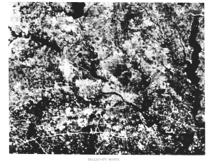
This is Dallas, Texas, near the center and a bit of Fort Worth along the left edge. The Trinity River runs through downtown Dallas towards the lower right. Interstate 20 passes E-W near the bottom of the scene and Interstate 30 follows parallel to it in the left center. I-635 is joined by I-20 on the east but in this scene, it is apparent that the former is not yet complete. Also, the white area in left center is the partially completed Dallas-Forth Worth International Airport.
The prime problem in identifying the location was that the atlas was about 5 years out-of-date. Several reservoirs and lakes clustered around Dallas -Fort Worth, which were built since its publication, were not depicted in the atlas, although several appear in this subscene (elongated black patterns). Thus, no one initially could match the broader Polaroid pattern to this incomplete map pattern with satisfactory certainty. Eventually, some “wise men” deduced that this was the cause of the misfit, and Dallas-Forth Worth officially was recognized as the inaugural ERTS scene. However, in fact, the first full black and white scene that they viewed later that day was a stunning cloudfree image of the Ouachita Mountains in eastern Oklahoma (bottom of page 6-3 and the first color composite covered the Monterey Bay to San Joaquin Valley section of California, shown in the middle of page 2-8.

Before reading on, study this image to see the obvious anomaly. You may want to look again at the full scene images of New York City to refresh your awareness of image shape.
Remember that this shape (New York City image) is a rhombus with the upper part tilted to the right. This is the consequence of the Earth turning (counter-clockwise or W to E) under the spacecraft as it passes from north to south. Each successive scan sequence shifts slightly to the west. When processed, the image must express this by its vertical boundaries being moved progressively to the left. Somehow, this was not done correctly as the technicians rushed to get the first color composite to the waiting ERTS specialists, so that the upper part is tilted left instead of the usual right.
Throughout this Section we have taken looks from space and the ground at modern cities, although some have old roots. As a finale, let’s look at two striking examples of how remote sensing participates in archaeology. This next scene is historical in a different sense. It was taken by the IKONOS sensor that has already been introduced to you. The resolution here is 4 meters. Before reading the next paragraph, take a wild guess as to its identity (clue: it is in modern Turkey not too far from Istanbul).

Next to Pompei, near Naples, this is probably the most famous rediscovery and excavation in modern times. The city is the fabled Troy written about by Homer. It was settled by the Aecheans of early Greek history and was laid siege around 1200 BCE by the Greeks; it is where Hector defeated Achilles and where the myth(?) of the Trojan Horse led to the downfall of King Priam. Ultimately, it was rebuilt and buried several times so that its very existence was questioned. But, the German archaeologist Heinrich Schliemann firmly believed it was real and out there somewhere. Beginning his digging in 1870, he eventually proved to the world that this lost city was an historical fact.
Remote sensing has had several notable successes in finding evidence of buried cities. One is the lost “Arabian Nights” city of Ubar, which was an important trading center in the eastern Arabian Peninsula (in today’s Oman) for several thousand years until it disappeared perhaps around 300 AD. Using remote sensing, Dr. R. Blom and others found evidence in this Landsat image of ancient trails that led to a spot on the side of a mountain.
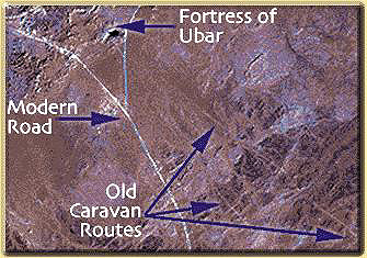
SIR-C radar (see`page 8-7 <../chapter08/Sect8_7.html>`__), operated from the Space Shuttle, also could pick out these caravan roads (in pinkish-red) that seemed to converge near a dry stream or wadi.
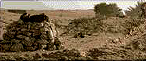
When these archaeologists visited the site area singled out in the imagery, and carried out a “dig”, they found evidence (including remnants of walls at the surface) of a large fortress that guarded this city, which apparently was destroyed by invaders after capture.
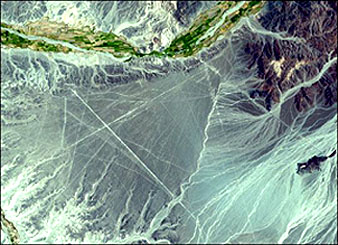
One of the most famous - and mysterious - sites of some, still not adequately explained, ancient activity is the Nasca lines in the dry hills and plains in Peru. This Terra ASTER image shows these features: remarkably straight lines as much as 10 km long, some of which cross. Imaginative interpreters postulate these to be landing strips for extraterrestrial vehicles (space ships). Other views ascribe them to some project conducted by pre-Columbian South American natives.
Remote sensing has had a number of other successes in helping archaeologists to search for new ancient sites or extend their knowledge of ones being worked on. On page 15-10 this subject is reviewed in depth, using an example of Celtic-Roman-Medieval ruins in Burgundy, France, analyzed both by SPOT and radar and by the GIS methodology.
Now, let’s leave “town” to journey again into the vast countryside, this time by considering in Section 5 views of southwest Utah and the Plains of Oklahoma, as examples of how remote sensing contributes to mineral and oil/gas exploration.
Primary Author: Nicholas M. Short, Sr. email: nmshort@nationi.net