Using Landsat for Geological Studies
The making of a geologic map with the aid of remote sensing imagery is illustrated for an area in Utah known as the Waterpocket Fold (a monocline as defined on this page). Its location with the Colorado Plateau is specified and that major geomorphic/structural unit is described and illustrated. A Landsat TM 1 image of the Fold area is introduced and several aerial oblique photos and ground shots help one to visualize the geologic units and terrain found there.
Using Landsat for Geological Studies
With these provisos in mind, we view the first scene to be analyzed. It’s a demonstration of the mapping capabilities of a subset from a Landsat TM image dominated by the Waterpocket Fold that lies within the Capitol Reef National Park in south-central Utah about 35 miles south of Caineville on Highway 24.
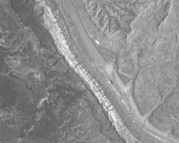
` <>`__2-3: The Waterpocket Fold is shown in this image just above. Examine the Landsat TM Band 2 scene closely. How many distinct and different units do you think you can distinguish in this band, based solely on gray level variations? `ANSWER <Sect2_answers.html#2-3>`__
The Capitol Reef Park is well within the Colorado Plateau, a major physiographic province that extends across parts of Colorado, New Mexico, Arizona, and Utah. The Plateau’s best known natural feature, of course, is the Grand Canyon. There, the Colorado River has cut nearly a mile deep into horizontal rock strata of Paleozoic age. These horizontally layered sedimentary rocks are the hallmark of the Plateau. Over most of the U.S., great forces from lateral interactions between the North American and Pacific tectonic plates and other plates have caused strata in the upper continental crust to be folded, faulted, and crushed into numerous mountain belts, of which the Rocky Mountains, the Wasatch, the Pacific Coast Ranges and many others are prime examples This is one of the central ideas in the great paradigm known as Plate Tectonics (plates are subcontinental scale blocks or segments of the Earth’s lithosphere; the term “tectonics” refers to the large-scale deformation and movements of/in the Earth’s crust, leading to such structural features as folds, faults, thrust blocks, and fractures). However, in one region in the West - the Colorado Plateau - the crust responded differently by being lifted vertically while maintaining the initial horizontal orientation of the cover strata, rather than being compressed laterally into deformed units.
In the Plateau, there is one structural exception to this. In places, the rocks are gently folded in broad warps called anticlines and synclines, in which rock layers become inclined (we say they dip) in opposing directions. Even more common are a type of folds called monoclines.
The scene below is a beautiful Landsat MSS full scene taken on June 13, 1977. That shows the northwestern section of the Colorado Plateau, including parts of the so-called Canyonlands. The subscene you will study is near its upper left corner; the black line marks the flight line of a NASA aircraft overflight during which a multispectral scanner acquired data (see next page).
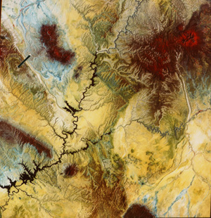
Most of the upper scene lies in Utah but the lowermost areas fall within northern Arizona. Passing through the scene is the Colorado River that, backed up from the Glen Canyon Dam (lower left) near the town of Page, Utah fills the steep-walled canyons to form Lake Powell. The San Juan River joins the Colorado from the east. The prevalent yellow color in this image (printed on Cibachrome, which improves both color quality and definition of features) corresponds mainly to sandstones and some shales that are reds and oranges in nature. The brown tones associate with rocks that are dark reds and browns in the field. Some fields are tinged with reds in the image because vegetation in this IR version. Blues associate with shales that in the field are often grayish. Areas with strong red (IR) tones include the Abajo Peaks (upper right), the Henry Mountains (upper left), and the smaller, isolated Navajo Mountain east of Lake Powell. The northernmost end of the forested Black Mesa appears along bottom center. The cluster of isolated mountains to its north are the collection of mesas and buttes, known as the Hopi Buttes district. Instead of being made from sedimentary rocks, as occurs in Monument Valley to the north, these are actually eroded volcanic necks and diatreme fills. From the ground they look like this:
Along the right side of the Landsat image is a long band of folded rocks that comprise Comb Ridge. In the upper left is the monoclinal fold (crossed by a black line) known as the Waterpocket Fold, which is the topic of the next few pages of Section 2.
In a monocline, forces cause rocks to change their inclination in only one direction and then resume the initial direction, as depicted in this sketch which presents a side view (as though it was along a vertical
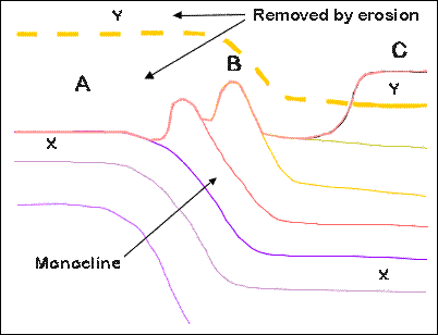
cut into the Earth’s surface layers) of a monocline. At the top is a line which represents a profile of the ground surface. At B, above the inclined layers, rocks that are more resistant to erosion are shown as ridges (often called “hogbacks” or “flatirons”). At A, a rock unit labeled X lies just beneath the surface, but at B it has dipped downward such that it is now well below the ground. A unit labeled Y at C is well on top of X. These rock units and the rocks in between follow the stratigraphic Law of Superposition, which states the obvious: younger rocks are deposited on, and thus rest above, older rocks. If we follow Y to the left along a dashed line, it bends upward at B and also lies above the ground at A. In other words, it was once there but has been removed by erosion.
` <>`__2-4: The two most common types of folds are called anticlines and synclines. Do you know what these structural terms mean? If not, check the answer. `ANSWER <Sect2_answers.html#2-4>`__
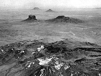
This is the situation at the Waterpocket Fold, a monocline which runs across this subscene. A black & white view followed by a color view, both taken looking to the northwest from low-flying airplanes, show a

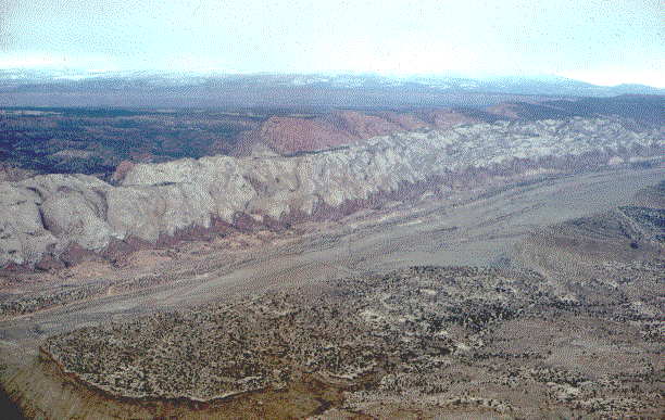
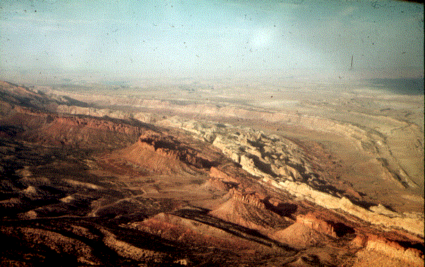
hogback ridge dominated by a whitish unit, the famed Navajo Sandstone (the principal rock formation at Zion National Park) and several other (reddish) units near its base. The thick red unit beyond (west) the Navajo Sandstone is the Wingate Formation. These several units dip at angles as steep as 45 degrees. Younger gently dipping rocks in the foreground (bottom of photo) are part of the lower bench of the Tarantula Mesa whose top (east of the photo; equivalent to C in the above diagram) is actually higher in elevation than the fold. We can barely see older rocks (equivalent to A) below the distant western horizon. These make up the Circle Cliffs. A third aerial view taken from the west side of the fold looking to the northeast, presents these older rocks to the left and younger rocks in the distance, with the Fold highlighted by the Navajo Sandstone and standing out as a narrow band of outcrops along the structurally-controlled topographic ridge.
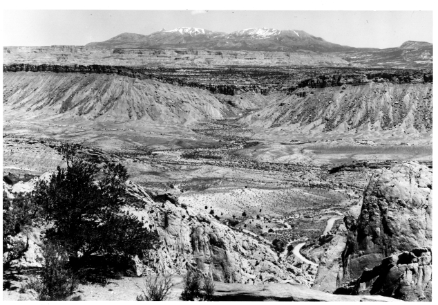
Now, we take two close-up looks from the ground, one looking up against the Fold with the Navajo Sandstone near the top and the Entrada Sandstone (reddish) below it but stratigraphically young.
Entrada Fm (reddish) and the Navajo Fm (white).|
` <>`__2-5: In the first aerial oblique color photo (which the writer made literally hanging out the window of a light aircraft), how many rock units within the steeply inclined limb of the monocline can you separate visually. In the black and white aerial oblique photo, the slightly inclined rock units along the right side margin seem blackish; why? **ANSWER**