Probabilistic Neural Network Classifier
Staff of the original sponsor of this Tutorial, Code 935 at Goddard Space Flight Center, have developed an image processing program called PIT, which is attached to the Tutorial in Appendix C. It includes a Maximum Likelihood classifier. Another classifier devised at 935 uses neural network theory to produce a Probablistic Neural Network (PNN) means of classification. An example is shown which is apparently less accurate than those used on the preceding two pages; however, the number of classes was limited to 10 so their geographic distribution would diverge from those other classifiers using more classes. Section 1 closes with a challenge to the individual(s) working through this Tutorial: to take an “Exam” that tests your mastery of some of the concepts developed in the Introduction and this section.
Probabilistic Neural Network Classifier
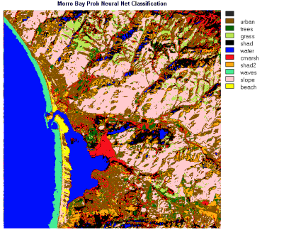
In this version, only 10 classes were established (the upper limit at the time). The resulting product shows similarities to the IDRISI Minimum Distance version (in which, there are 13 classes) but it is a simplification of the latter that fosters easier interpretation. However, several classes show notable misclassifications: areas of blue assigned to Water are found scattered inland (these are probably associated with shadows which have similar, low DN values); the reds related to Marsh (which should be confined to the river delta) also appear in widespread places, including the higher mountains; and the red-brown color given to Urban is in too many places that are certainly not urban. The orange, identified as Shad2, is definitely not shadows, but corresponds to areas in the scene that have bright tones in the color composite images. This was a bad choice of a class.
In Appendix B, the PIT image processing program is fully described. It is now accessible to you for interactive use by downloading either from the Internet or from the CD-ROM; instructions on how to do this are given in that appendix. Among the several data sets included is this Morro Bay subscene, of which you are now quite familiar. If you feel adventuresome after this exposure to image processing, you may want to try your hand at carrying out your own processing on the Morro Bay subscene, using the PIT processor, after teaching its procedures to yourself using the “cookbook” in Appendix B. There are also several other data sets from different Landsat or SPOT scenes which can be downloaded as well; some guidance as to what you can do specifically with them is offered at the end of the appendix.
PIT is in the public domain and thus available for you to use as a training aid. A considerable number of image processing systems and programs are now on the market, i.e., are commercial products. Perhaps the most widely used software packages are supplied by ERDAS, Inc. of Atlanta, GA. A visit to the ERDAS Web Site (ERDAS is now part of Leica Geosystems) can help you to appreciate these sophisticated systems. At that site, there are online Tutorials on Remote Sensing, and on their MapComposer and IMAGINE processing software which are very much worth time to work through. You will need to register and get a password, and indicate whether you would like to be placed on their mailing list. To help you envision what the systems look like on a computer screen, we have reproduced three examples below (check the captions for details).
Enough! If you have reached this point by working through this entire Section and reasoned along with us in examining and analyzing the various Morro Bay images, you have become well-schooled in the basics of image interpretation. You are ready, as curiosity prompts you, to examine the processed images in the next Section - which starts with a geological study of a prominent fold structure in Utah - as well as many of the images in other Sections that have been processed to show outputs similar to those with which we have just become familiar. In most such cases, the interpretation has been done for you (as placed in the text) but the knowledge gained from Section 1 will aid you in better appreciating the information content in such images - perhaps to the extent that you can extract more from them than is stated in the text.
At this stage you have two options. You can choose to continue reading sequentially through this Tutorial, starting with what is offered in the next paragraph, or you can choose to pursue this image processing theme and develop your own skills right away by interactively working on the Morro Bay image set and/or three other image sets using the PIT processing program described and accessed through Appendix B.
WAIT! If you are actually (or pretend to be) in a classroom as you access this Tutorial on the Net or on the CD-ROM, you know the “curse” to expect after completing the first major block of information. An Exam!. We have devised a rather comprehensive set of questions based on image interpretations that we now invite (urge) you to undertake, in order to prove to yourself that you have evolved into a full-fledged expert in analyzing remote sensing data. We have reproduced a goodly number of scenes and computer maps that cover a single full Landsat MSS scene, with in south-central Pennsylvania centered on the state capital, Harrisburg. (These have been taken from the Landsat Tutorial Workbook.) All the relevant questions and illustrations have been put on the special add-on page, which you can reach by clicking here. These have their own answer sheet, accessed in the usual way. This, and a final Exam at the end of Section 21, will be the ultimate Q & A challenge we toss at you in this Tutorial. Rise to it. Press “here” - we dare you!!
For further background, information, and reading underlying Principles of Computer Processing, with emphasis on Remote Sensing, consult:
Avery, T.E and G.L. Berlin, Fundamentals of Remote Sensing and Airphoto Interpretation, Ch. 15, Digital Image Processing, 1992, Macmillan Publ. Co.
Condit, C.D. and P.S. Chavez, Jr., Basic Concepts of Computerized Digital Image Processing for Geologists, 1979, U.S. Geol. Surv. Bull. 1462, Wash. D.C.
Jensen, J.R., Introductory Digital Image Processing, 2nd Ed., 1996, Prentice-Hall, Inc.
Xiuping Jia, Remote Sensing Digital Image Analysis, 1999, Springer-Verlag
Lillesand, T.M. and R.W. Kiefer, Remote Sensing and Image Interpretation, Ch. 7, Digital Image Processing, 2000, J. Wiley and Sons, Inc.
Moik, J.G., Digital Processing of Remotely Sensed Images, 1980, NASA Special Paper 432, U.S. Govt. Printing Office.
Russ, J.C., The Image Processing Handbook, 1995, CRC Press.
Sabins, F.F., Remote Sensing: Principles and Interpretation, Ch. 7, Digital Image Processing, 1997, W.H. Freeman & Co.
Special Issue on Image Processing, 1990, Photogrammetric Engineering and Remote Sensing, v. 56, no. 1.
Swain, P.H. and S.M. Davis, Remote Sensing - The Quantitative Approach, 1978. McGraw-Hill Book Co.