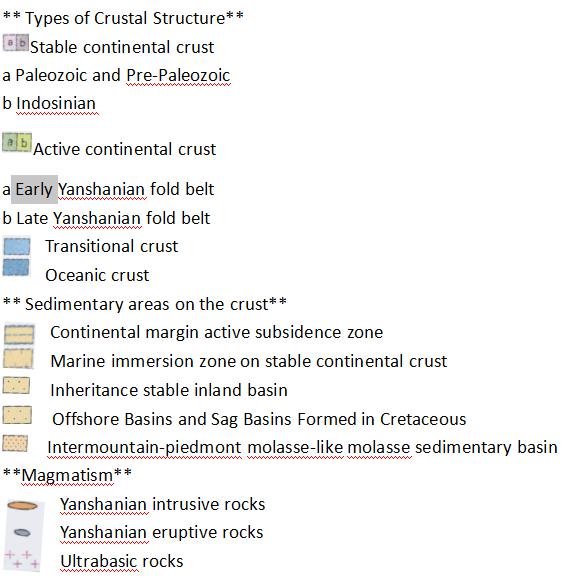
Paleostructures of the Yanshanian Stage in China
The Yanshan Movement, a general term for the crustal movement of Jurassic and Cretaceous in China, was about 6.6 million years ago. It is named after the Yanshan Mountains in northern Hebei Province, China.The fold belt formed by Yanshan movement is called Yanshan fold belt. The Yanshanian movement uplifted the continents of the world as a whole and further eroded their landforms.In Eastern China, the provinces of Sichuan, Yunnan and Guizhou in southeastern and southwestern China, as well as in the eastern part of the South-Central Peninsula in southeastern Asia, the Russian Far East, the Rocky Mountains in Western North America and the Mexican Plateau, all have wide influence,which are the general name of the most common crustal movement in China, about 6.6 million years ago.It is named after the Yanshan Mountains in northern Hebei Province, China. The fold belt formed by Yanshan movement is called Yanshan fold belt.The Yanshanian movement uplifted the continents of the world as a whole and further eroded their landforms. Sichuan, Yunnan and Guizhou provinces in eastern, southeastern and southwestern China, as well as the eastern part of the South-Central Peninsula in southeastern Asia, the Far East of Russia, the Rocky Mountains in Western North America and the Mexican Plateau, all have wide influence,which are the most common crustal movement in China.It has created important geological structures in too many areas of China and laid the basic outline of China's topography. Because the landform has been eroded by one step. Some new small Intermontane basins have been formed. The original basins were eroded by rivers, merged with each other or extended along faults.With the Yanshanian movement, a large number of granite formation and volcanic eruption resulted in the formation of copper, iron, rare metals, rare earth elements and other rich mineral resources. In addition, coal, oil, natural gas, oil shale, gypsum, limestone, building stone, sodium salt, potassium salt and so on are also rich.
Comment list ( 0 )

