Sui and Tang Dynasties, the Five Dynasties period (AD 581 - 960), a total of 379 years. During this period, socio-economic activities were still concentrated in the Yellow River Basin to the Yangtze River Basin and parts of southern China. Therefore, the natural disasters recorded in the literature are mainly distributed in these areas.
Floods, droughts and freezing disasters, hail is the main natural disasters during this period.
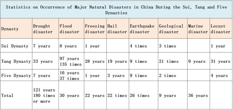
Floods, droughts, freezing, hail disasters. Sui Tang 37 years, 8 years of floods, 7 years of drought, 1 year of frozen disasters. The year of heavy floods was 611 years and 617 years, and the areas of Shandong and Henan were flooded. The drought years were 584 years, 594 years and 611-612 years. The disaster areas were the worst in Henan, Anhui, Jiangsu, Hubei and Sichuan.
In the 289 years of the Tang Dynasty, there were 135 floods in 1997, 33 years of drought, 28 years of freezing disasters, 19 years of hailstorms and 9 years of marine disasters. Of which more than one thousand deaths of water more than 30 times, such as 654 years, 726 years, 727 years, dozens of states affected. The main floods come from the Yellow River, followed by the lower reaches of the Yangtze River. Drought-prone period is 680-688 years, 714-719 years, 798-804 years, 861-869 years.
During the 53 years of the Five Dynasties, there were 37 floods in 16 years, 7 years of drought, 1 year of freezing disasters and 3 years of hailstorm. Severe years of flooding were 946 years and 952 years.
Earthquake disaster - frequent activities, recorded more than 6 destructive earthquakes 22 times. Such as 649 years Linfen earthquake, more than 5,000 people died.
Marine disasters - mainly typhoons and storm surges, a total of 9 years, mainly in Shandong, Jiangsu, Shanghai, Zhejiang, Fujian coastal areas. Among them, 669 years, occurred in Zhejiang state (now Lishui) typhoon, storm, storm surge submerged Yongjia, Angu, drowning 9070 people, destroy field 4510 ares.
Locust disaster - a total of 159 years of locusts, of which the largest locusts in 36 years to the Yellow River Basin in Shandong, Henan, the most serious, Shaanxi, Hebei and Zhejiang, Jiangxi, followed by some areas.
Geological disasters - collapse, landslides, debris flow, mainly in Shaanxi, Gansu, Sichuan, Qinghai, Hubei, some areas.
The map comes from "China's major natural disasters and social Atlas"
Comment list ( 1 )

it is very good resource.

