
Spatial decision support model
Regional planning, land use planning, facility location selection and environmental management are all decision-making problems related to spatial behavior. The solutions to these problems are obtained by decision makers or experts inspired by professional knowledge and experience, based on the analysis of a large number of spatial and non-spatial information. The problem of spatial decision-making greatly exceeds the requirement of the usual spatial analysis function of GIS.
Complexity of spatial decision-making process
Decision-making is a complex process in which a decision maker chooses a certain target or target set and chooses among multiple candidate options according to certain constraints. When express generalized decision problems with mathematical expressions, the following components are included:
1) Scenario Collection: The decision set of the decision problem refers to the set of action plans that can be selected, denoted as A.
2) State collection: Any decision problem faces a certain external environment, called state, the various possible states of the system, called the state collection, are denoted as Q.
3) Profit and Loss Function: This is an important concept in decision analysis, in the decision-making problem, if the strategy is adopted, it is assumed that the system status appears and the system benefits. Therefore, a profit and loss function that maps to a decision problem is defined, in the case where A and Q are countable, the income statement can be obtained as shown below (Table 10-2).
Table 10-2: Decision profit and loss statement
Q:sub:`1` |
Q:sub:`2` |
… |
Q:sub:`n` |
|
|---|---|---|---|---|
A:sub:`1` |
W11 |
W12 |
… |
W1n |
… |
… |
… |
… |
… |
A:sub:`m` |
Wm1 |
Wm2 |
… |
Wmn |
4) Objective function (decision criteria): is denoted as F. The profit and loss function only gives the actual income of the system, but does not give the evaluation criteria of the income, that is, the optimization criterion when “choice”. Decision criteria are different for different decision makers, problems, and methods, and ultimately determine the formation of the program.
In summary, a decision-making problem can be described as:
Among them, F is the objective function or decision criterion, A is the candidate scheme set, Q is the state set, W is the profit and loss function.
Conventional methods of decision-making are used to solve ordinary decision-making problems, which satisfy the following conditions:
There are clear goals that policymakers want to achieve.
There are alternatives that can be chosen by decision makers and whose components can be identified.
There exists a system state which is not controlled by the decision maker, and the system state set and candidate scheme set are independent of each other.
The profit and loss value can be accurately quantified, A and Q are countable sets.
When the number of states in the system state set Q is n=1, it is a deterministic decision-making problem; when n>1, and the probability of each state of the system is unknown, it is an uncertain decision-making problem; when n>1, and the probability of each state of the system obeys a known probability distribution, it is a risk decision-making problem.
Spatial decision making has the same deterministic decision, uncertainty decision and risk decision as general decision problem. Deterministic decision-making is actually an optimization problem, multi-criteria decision-making and linear programming like land suitability evaluation are such decision-making problems, and they can be fully integrated with the spatial analysis function of GIS. A large number of spatial decision-making problems often involve different forms of knowledge such as structural, unstructured knowledge, human evaluation and judgment, and the uncertainty of decision-making and risk components are large. taking facility configuration as an example, domain experts already have a set of discriminative rules on location suitability, these rules are knowledge expressed in descriptive ways, the choice of facility location is based on the analysis of factors related to socio-economic, geological conditions, environmental quality and other factors, the reasoning process inspired by the discriminative rules; in addition, domain experts also have evaluation models for socio-economic, geological conditions and environmental quality, these knowledge are all programmatic knowledge, the choice of facility location is based on the estimation process based on the quantitative model calculation analysis.
With the rapid development of information technology, more and more spatial and non-spatial information is provided to decision makers, including maps, aerial photos, tables, remote sensing and digital measurement signals. Decision makers need to effectively process and understand these vast amounts of information through knowledge and experience. Human knowledge can be divided into two types: structured and unstructured. Structured knowledge has highly structured forms and structured solvers, including mathematical models, statistical methods, and computer algorithms, these types of knowledge follow a fixed framework for performance and analysis, in most cases, only Can be understood by experts, also known as Procedural Knowledge.However, a large amount of knowledge is unstructured, like human experience, intuition, values, and expert experience, which is qualitative in nature and cannot be expressed by a fixed program, also known as Declarative Knowledge.
Decision makers use information and knowledge to solve structured, unstructured and semi-structured problems with varying degrees of complexity. Taking facility allocation as an example, it is a structured problem to allocate the minimum number of facilities under certain constraints, which can be solved by optimization method; finding all possible locations of optimal facility allocation is a semi-structured problem, involving multiple criteria evaluation and value evaluation; and determining overall objectives and general policies for facility allocation is a non-structured problem. Questions, involving flexible qualitative problems, can not be solved with fixed formula knowledge.
In short, spatial decision-making is a complex process involving multi-objective and multi-constraints, which can not be solved simply by descriptive knowledge or programmatic knowledge. It often requires comprehensive use of information, domain expert knowledge and effective means of communication, information and knowledge often interact in spatial decision-making, as shown in Figure 10-5.
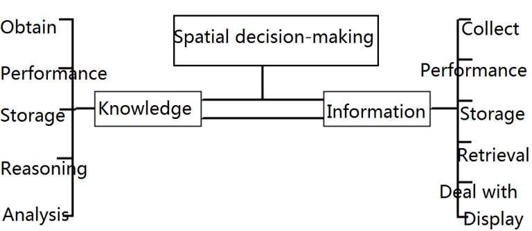
Figure 10-5: Spatial decision-making process
One side of the information processes the collection, presentation, storage, retrieval, processing, and display of data for computation and measurement, as well as knowledge reasoning and updating. The side of knowledge deals with the acquisition, presentation, storage, and reasoning and analysis of knowledge for processing facts, organizing information, and principles. The interaction of knowledge and information in decision-making is an extension of traditional information technology, without knowledge reasoning, it is impossible to make intelligent decision-making.
GIS provides powerful data input, storage, retrieval, and display tools for decision support, but its functions in analysis, simulation, and reasoning are weak, it is essentially a data-rich but theoretically poor system that solves complex spaces, there is a lack of intelligent reasoning on decision making issues. Therefore, in order to solve complex spatial decision problems, it is necessary to develop an intelligent decision support system based on geographic information system for data acquisition, input, storage, analysis and output. Used for knowledge representation and reasoning; for automatic learning, system integration, human-computer interaction. The new technologies used include artificial intelligence technology, knowledge acquisition techniques such as knowledge acquisition, performance, and reasoning, as well as software engineering techniques that integrate databases, models, unstructured knowledge, and intelligent user interfaces.
Theory and method of spatial decision analysis
Utility theory
Utility theory is the basis of decision analysis. The uncertainty of things can be seen as a composite of many simple random events. Each simple random event consists of two mutually exclusive events Z:sub:`1` and Z:sub:`2`. The event Z:sub:`1`has a probability of P, and the event Z:sub:`2`has a probability of 1—P, then random The event is recorded as L(Z:sub:`1`, P,Z:sub:`2`). Introduce the concept of “priority” or “preference” in a simple random event and establish an axiom system based on a set of random events, assuming that the following conditions exist in the random event set:
Relative preference order;
Preference relationship is transitive;
Comparability between simple random events;
Preference relationship can be quantified.
Uncertainty can be quantified.
Equivalent random events can be substituted for each other.
Under such conditions, a numerical value can be used to describe the expected benefit of a simple random event, called utility. The utility of a general random event can be determined by the utility of a simple random event. In quantifying event uncertainty judgments, it is necessary to use various knowledge, such as the characteristics of the system itself, some necessary statistical knowledge, and subjective estimation of event uncertainty by decision makers based on experience.
Decision tree
One of the most commonly used methods in decision analysis is the decision tree approach, and Figure 10-6 shows a typical decision tree. The small rectangular box in the figure represents the decision point selected by the person. Draw the problem process that needs to be made into a schematic diagram, starting from the leftmost side of the diagram and experimenting before making a decision. For example, there are Rtrials L:sub:`r`, the fee is C:sub:`r`, and the test results are O:sub:`1` *,…,*O:sub:`t`,…,O:sub:`T`and so on. The probability of occurrence of O:sub:`t` under the test L:sub:`r`condition is recorded as P:sub:`rt`(O: Sub:`t`). Let there be d:sub:`1`,…d:sub:`i`,…,d:sub:`I`etc. I *Alternative decision making options. If you choose the decision *di, then S:sub:`1`,…,S:sub:`j`,…,S:sub may appear. :`J`Total JStatus. When the result O:sub:`i`appears in the test L:sub:`r`, the decision diis selected, the state S:sub:` The probability of occurrence of j`is recorded as P:sub:`rti`(S:sub:`j`). There may be L consequences at this time*x1`*,…,*x:sub:`l`*;,…,*x:sub:`L`*, and *P:sub:`rti(S:sub:j)*means that the result in the experiment L:sub:`r`is O:sub: When `t`, select decision d:sub:`i`and the status S:sub:`i`appears, S:sub:`j` *The probability of a consequence *x:sub:`l`whose utility is recorded as U(x:sub:`l`). The decision tree method is to analyze along the branches of the tree, calculate the probability of various possible situations, and finally calculate the effect of the final consequences under these conditions, compare the various effects, and select the best utility, corresponding trials and decisions are taken as decisions to be taken.
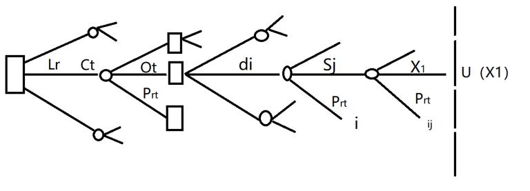
Figure 10-6: An example of a decision tree
Bayesian decision making
Because decision-making is always made before an event occurs, and whether an event occurs is uncertain, Bayesian formula in statistics is often used to estimate the probability of an event, which is called Bayesian method.
Because the occurrence of events is uncertain, it makes the decision-making with a certain degree of experience. People have different attitudes towards style and different estimates of utility. Those who hold a conservative view on the development of events and are reluctant to venture tend to underestimate their utility, while those who tend to venture tend to overestimate their utility. Others take a moderate attitude and estimate the utility between the two.
Spatial decision support system
Decision Support System (DSS) is a computer application system that assists decision makers to make semi-structured or unstructured decisions through human-computer interaction through data, models and knowledge. It is developed on the basis of Management Information System (MIS), on the basis of MIS, it adds unstructured problem processing, model calculation and various methods. it provides a broader method for solving structured, unstructured and semi-structured problems. which provides decision makers with an environment for analyzing problems, establishing models, simulating decision-making processes and schemes, and calling various information resources and analysis tools to help them improve their decision-making level and quality. Decision Support System (DSS) is a computer application system that assists managers to make decisions on semi-structured problems, supports rather than replaces managers’judgments, and improves decision-making effectiveness rather than efficiency. The basic structure of DSS is mainly composed of four parts: data part, model part, inference engine part and human-computer interaction part, as shown in Figure 10-7.
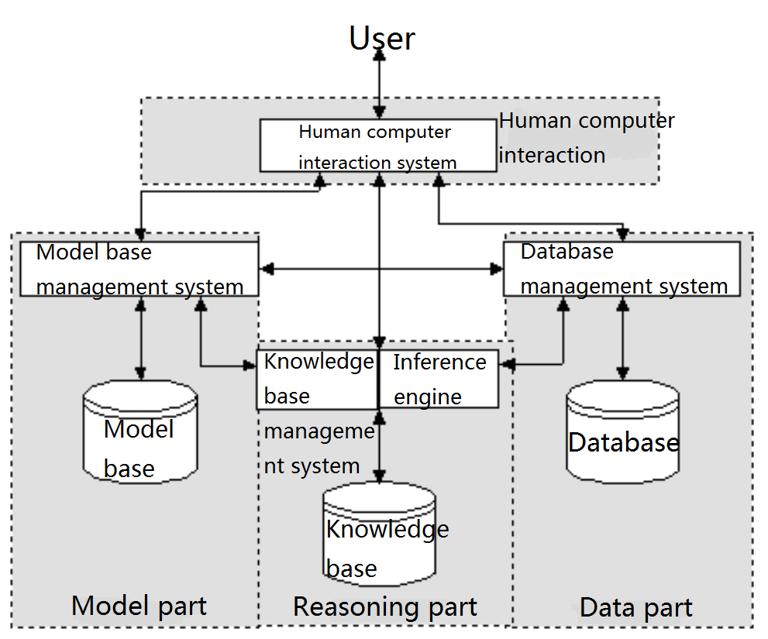
Figure 10-7: Components of DSS
Corresponding to MIS, GIS can be regarded as a spatial information system for spatial decision making. The difference between GIS and MIS lies in the complexity of its data model and data structure. At present, the analysis function of GIS is still weak and inflexible, and its logical structure and intelligent level cannot meet the needs of solving complex spatial decision problems, especially those unstructured. In order to better assist spatial decision-making, GIS needs to increase the processing function of descriptive knowledge and programmatic knowledge. At present, GIS is not suitable for the processing of various knowledge forms, and cannot be used as the nerve center of spatial decision support system (SDSS), but as an integral part of it, GIS can be embedded in an SDSS for spatial information processing.
The spatial decision support system has the same nature as the general decision support system, but only pays more attention to the acquisition and resolution of spatial data and spatial problems. Usually the spatial decision support system includes the following features:
The acquisition, input and storage of spatial and non-spatial data from different data sources;
Complex spatial data structure and spatial relation representation method are suitable for data query, retrieval, analysis and display.
Flexible integration of programmatic spatial knowledge (mathematical model, spatial statistics) and data processing functions;
Flexible function modification and expansion mechanism;
Friendly human-computer interaction interface;
Provide multiple outputs for decision-making;
Provide a formal expression method of unstructured spatial knowledge.
Provide reasoning mechanism based on domain expert knowledge;
Provide automatic knowledge acquisition or self-learning function;
It provides an intelligent control mechanism based on spatial information, descriptive knowledge and programmatic knowledge.
These functions are beyond the scope of current GIS, and need to integrate the latest technologies in the fields of artificial intelligence, knowledge engineering, software engineering, spatial information processing and spatial decision theory.
General intelligent spatial decision support system architecture
The establishment of a spatial decision support system can solve decision-making problems in specific areas. But its establishment process is a long-term project, and it can only be used in special fields, so the most economical and flexible way to establish a spatial decision support system is to use software engineering and knowledge engineering methods to develop spatial decision support, the system development environment (shell or generator) allows domain experts to quickly and efficiently build multi-domain spatial decision support systems. In other words, to develop a common development tool, decision makers can be used to customize, modify, adjust, and extend the spatial decision support system to solve specific spatial decision problems. Figure 10-8 is a structural diagram of a general space decision support system.

Figure 10-8: Architecture diagram of a general space decision support system
The core of the system is an expert system shell (Shell), which can be used as an expert system development tool, directly controls the control flow and information flow of SDSS, provides knowledge of unstructured domain of expression and storage, and also includes inference control and system, meta-knowledge with user interface and external communication, and inference engine for unstructured spatial knowledge. It is the brain of SDSS. To use both spatial and non-spatial data, the expert system shell has an interface to an external database, including GIS, relational databases, and remote sensing information systems. The model management system manages and processes programmatic knowledge including algorithms, statistical programs, and mathematical models. It also has an interface to the expert system shell that can be called through the meta-knowledge of the expert system shell. In addition to the interface with the database management system and model management system, the friendly user interface and knowledge acquisition module are also the basic components of the expert system shell.
This section focuses on the model management system of the spatial decision support system, the database management system has been introduced in the previous chapters. The knowledge base and knowledge processing will be discussed in the expert system in the next section.
Model management system for spatial decision support system
In order to solve various complex spatial problems that occur in the natural and human processes, scholars have proposed a large number of structured models, including statistical methods, mathematical models, heuristic programs, algorithms, etc., which are different from descriptive knowledge with a highly structured format and a fixed executive. These models are useful for solving structured decision problems, but unfortunately their formal logic and solutions are often difficult or time-consuming for decision makers to understand, especially those that are not technical. Decision makers are more likely to confuse or improperly use them effectively, thus limiting the effective use of this type of knowledge. In addition, these structured models are used in the GIS environment, and there is a problem with the compatibility of the GIS data model. The interaction between the model and the GIS database is a basic requirement, therefore, the spatial decision support system needs to properly select and organize related models, corresponding to the database management system that manages space and non-spatial data, there must be a model management system. The model management system should have the following features:
Help users select models related to analysis;
Classification and maintenance of various types of models to support decision-making processes at various levels;
Combine complex models with model sub-modules.
Provide appropriate data structure to satisfy query, analysis and display; satisfy embedding or data exchange with database; satisfy the exchange of model and descriptive knowledge;
A friendly interface for user consultation and result interpretation is provided.
The efficient classification and organization of the model by the spatial decision support system is the core function of the decision support system. Classifying models and organizing them at different levels of depth can effectively manage and use the model. For example, the first-level classification can be performed according to the decision problem, and then the second-level classification can be performed according to the evaluation condition and state, and the deeper classification can be continued. An example of a classification is given below:
1) Classification of decision making problems
Level I classification:
Environmental problems
Land use planning problem
Resource allocation
Facilities allocation
Network problems
Hydrological problems
Geological problems
Coastline issues
Assuming that we are concerned with network problems, various models of network problems are organized into a second-level classification, as follows:
Shortest path
Spanning tree problem
The salesman is responsible for the problem
Multicast communication
Transportation problem
Commodity flow problem
For each selected question, you can continue to subdivide into more specialized types, such as commodity flow issues, which can continue to be divided into single-item and multi-commodity flow issues. To select a specific model, the user goes through a series of “yes or no” question guides until they find the model they need to solve the problem.
2) Classified by technical conditions
Table 10-3: Classification examples of decision-making problems
Deterministic model Uncertainty model Stochastic model Imprecise model |
Discrete model Continuous model |
Static model Dynamic model |
Discrete model Continuous model |
Linear model Non-linear model |
Single objective model Multi-objective model |
Real type Integer |
According to the above classification, a decision tree can be constructed, and the model classification knowledge is expressed by a knowledge expression manner, for example, this example can be represented by a production rule, and each path corresponds to one rule. In this example, there are 2:sup:6rules for deterministic classification, one of which is described as follows:
Table 10-4: Decision rules
IF situition uncertain AND
cause random AND
space discrete AND
process dynamic AND
time discrete AND
system linear AND
objectives single AND
*variables real *
*THEN select multiple-stage, single-objective, discrete-space, *
*discrete-time linear stochastic programming model *
———————————————————————
Spatial decision support system in addition to the problem of model selection, the interaction between model and database is also an important issue. Different models have different data structures and different ways in which models interact with databases. The model needs to run in a GIS environment, and there is a compatibility issue with the GIS data structure.
There are different levels of interaction between model and GIS. The lowest level of interaction is to use GIS as a database management system to interact in the form of files, if the model and GIS are compatible with file types, interaction is only a simple problem of file selection; if the files are incompatible, it will involve the problem of file conversion. The higher level of interaction is to use GIS as a graphical display tool for displaying and analyzing model results. The highest level of interaction is the integration of the two in a complete system, the looser way is to re-implement the model with the operation commands of GIS (such as macro language); the closer integration is that the two have the data structure supporting query, analysis and display. Because of the diversity of models and the diversity of data structures, it is difficult to make the data structure of GIS compatible with the structure of all models. So the interaction between model and GIS allows for many ways in spatial decision support system.
