
Re classification
It is one of the important functions of Geographic Information System (GIS) to find hidden information by classification. Compared with the traditional map, the data on the map has been specially classified and processed, while the data stored in GIS has the nature of original data, so the data can be classified and extracted according to different needs. Because this classification is the reorganization of the original data, it is called Reclassification.
Geographic Information System (GIS) differs from other information systems in its processing function of spatial information, and also provides the processing function of non-spatial attributes. Although it is relatively simple, it plays an important role in practical application. According to the non-spatial attributes of geographic information, such as material, value, nature of use and so on, the classification based on non-spatial attributes is the same as other information systems in classifying simple structured data. Classical mathematical statistics methods can be used, such as principal component analysis, hierarchical analysis, clustering analysis, discriminant analysis and so on. This kind of classification belongs to the common classification, it does not change the existing attribute values of the objects, but only divides them into the corresponding categories according to the attributes of the objects. This chapter mainly discusses the re-classification of new features generated by classification organization through the attribute information of ground objects in GIS.
The reclassification of points and linear features can be realized by simply modifying the values in the attribute table for the vector data structure. For the raster data structure, the new points and line features can also be obtained by modifying the attribute values, the reclassification of the planar features, for the raster data structure, is the same as the point and line classification, simply changing the attribute values and changing the legend performance. For example, there is a raster map with attribute values from 1 to 15 representing a crop, if 1 to 5 and 13 are food crops, others represent cash crops, 1 to 5 and 13 can be reassigned 1 and the other numbers are assigned 2, a raster map of only two types of food crops and cash crops can be obtained, and the legend is changed to reflect this change. For the reclassification of planar features of vector data structures, it is necessary to change the geometry and properties of the entities at the same time. The first task is to remove the line between the polygons to be merged and then change the attribute values of the two polygons to the same attribute. As shown in Figure 8-4:
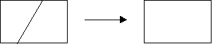
Figure 8-4: Merging Polygons
Because the new layer obtained by reclassifying the surface features has fewer categories than the original layer, called Group, it is the most common and simple reclassification. If you want to further decompose the planar features into different categories of features, you can’t use this method. Because you can’t know the position of the boundary, you can use another layer to achieve [1]_ by the polygon overlay method.
The above-mentioned re-classification methods are based on the attributes of the surface objects themselves, and achieve the purpose of classification by re-changing the attribute values. Of course, they can also be re-classified by combining the attribute values of the neighborhood range. For example, slope calculation and buffer calculation. Reclassification can also synthesize attribute information of multiple layers, as shown in Figure 8-5.
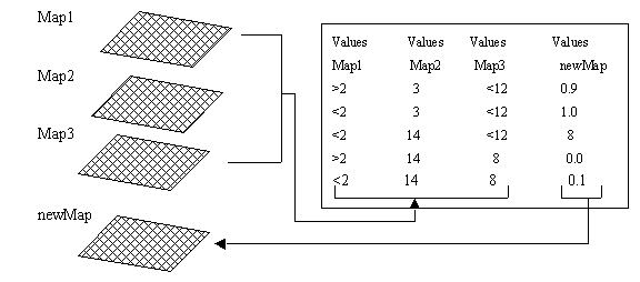
Figure 8-5: Reclassification of multiple attributes
