
Spatial-temporal model
Overview of Spatiotemporal Data Model
Research overview
Traditional GIS applications only involve two aspects of geographic information: spatial dimension and attribute dimension, so they are also called SGIS (Static GIS), while the GIS that can simultaneously handle time dimension is called TGIS (Temporal GIS).
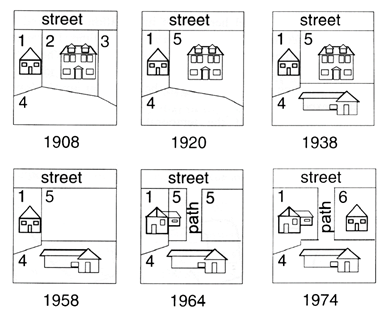
In GIS, data with time dimension can be divided into two categories: one is structured data, such as the accumulation of historical data of a station, which can be managed by simply adding a time stamp to the record of attribute data table. The other is unstructured, and the most typical example is the change of land use (Figure 3-17). This kind of data is the key problem to be solved in the TGIS data model.
TGIS data model is characterized by richer semantics and more accurate description of the real world. The biggest difficulty in its physical realization lies in the organization and access of massive data. The essential characteristic of TGIS technology is “space-time efficiency”. At present, the main TGIS models include: Space-time Cube model, Sequent Snapshots model, Base State with Amendments model, Space-time Composite model. Sequential snapshot model, like Analog GIS in GIS classification, is only a conceptual model and has no practical development value, while other models have their own characteristics and application scope, such as the base map correction model, which is more suitable for the development of TGIS in raster model.
Research Ideas of TGIS
The processing of massive data in TGIS will inevitably lead to fundamental changes in mathematical models. The final solution to the problem of TGIS lies in the emergence of a completely new mathematical idea which can be analogous to the theory of topology. At present, the technology of TGIS can be studied in order to realize the function of TGIS in the framework of SGIS. The research of TGIS model can be carried out in two ways: comprehensive model and decomposition model. Firstly, the decomposition model is used to study the typical application fields (such as land use dynamic monitoring) comprehensively. At the same time, the comprehensive model is constantly enriched and enriched. Finally, a relatively perfect comprehensive model is obtained.
Basic Ideas of Spatiotemporal Data Model Design
In the application fields of cadastral change, coastline change, land urbanization, road change and environmental change, it is necessary to preserve and effectively manage the historical change data so as to reconstruct the historical state, track changes and predict the future. This requires an efficient spatiotemporal data model to organize, manage and manipulate spatiotemporal data. Spatio-temporal data model is a kind of geographic data model which organizes and manages temporal geographic data effectively and has more complete semantics of attributes, space and time.
A reasonable spatiotemporal data model must consider the following factors: saving storage space, speeding up access speed, and expressing spatiotemporal semantics. Spatiotemporal semantics includes spatial structure, effective temporal structure, spatial relationship, temporal relationship, geographic events and spatial-temporal relationship of geographical entities. The basic guiding principles of spatiotemporal data model design are as follows:
According to the characteristics of the application field (such as macro-change observation and micro-change observation) and the objective reality change law (synchronous and asynchronous change, frequent change and slow change), the intensity of spatial/attribute cohesion and temporal cohesion of spatio-temporal data is compromised, and the object of time label is selected. For attributes, there are attribute data item time markers, entity time markers, database time markers. For space, there are coordinate point time markers, arc time markers, entity time markers, database time markers.
Provide static (inactive change) and dynamic (active change) data modeling tools (static and dynamic data types and operations). Current, historical and other data with different frequencies are organized and stored separately for easy access. Generally, the current data is stored on the local computer disk, while the historical data is stored on the large capacity CD-ROM of the remote server.
Two kinds of geographic events are explicitly expressed in data structure: evolution events of geographic entities and survival events of geographic entities. Geographical events are expressed in the relevant source state and termination state of events. The source state of the events constituting the existence or death of geographical entities is represented by the set of entity identifiers participating in the events. The essence of time is the sequence of events, and the sequence of geographical events directly indicates the semantics of geographical time. The common state change query is geographic event query.
Spatio-temporal topological relations generally refer to the temporal relations among the topological events of the spatial topological relations of geographical entities. Spatio-temporal topological relationships reveal the temporal and spatial correlation of geographical entities. In order to effectively express spatial-temporal topological relations, it is necessary to store time-varying sequences of spatial topological relations.
